
Greenock West railway station
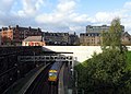
 View west from under Inverkip Street to footbridge, aqueduct and Newton Street tunnel | |
| General information | |
| Location | Greenock, Inverclyde Scotland |
| Coordinates | 55°56′50″N 4°46′04″W / 55.9473°N 4.7679°W |
| Grid reference | NS272761 |
| Managed by | ScotRail |
| Platforms | 2 |
| Other information | |
| Station code | GKW |
| Key dates | |
| 1 June 1889 | Opened |
| Passengers | |
| 2018/19 | |
| 2019/20 | |
| 2020/21 | |
| 2021/22 | |
| 2022/23 | |
| Notes | |
Passenger statistics from the Office of Rail and Road | |
Greenock West railway station is a station in Greenock, Scotland, located on the Inverclyde Line which runs from Gourock to Glasgow Central. The route is currently operated by ScotRail under the auspices of Strathclyde Partnership for Transport. Each service to and from Glasgow on the Inverclyde Line stops at this station.
History[edit]
Starting with PS Comet in 1812, Glasgow soon had Clyde steamer services on the River and Firth of Clyde. From 1841 the Caledonian Railway's Glasgow, Paisley and Greenock line offered quicker travel to its Greenock Cathcart Street terminus, about 5 minutes walk from Steamboat Quay (Custom House Quay) by a narrow squalid lane.[2][3] The 1865 branch line to Wemyss Bay had mixed fortunes, from then the Glasgow and South Western Railway (G&SWR) competed with the Caledonian for parliamentary approvals. In 1869 G&SWR services began to Albert Harbour railway station (at Princes Pier), taking away steamer trade.[4] Rival proposals were made for a line to Gourock, in June 1869 the Caledonian bought the existing Gourock harbour.[4] It later realigned its route to run beside the cemetery to the south of Greenock Royal Infirmary, to a station at the junction between Inverkip Street and Newton Street.[5]
Station design[edit]

The Caledonian Railway was granted permission in September 1882 to build the station, featuring "a very neat and substantial stone building in Renaissance style" at street level, with two "large and handsome" doorways from the booking hall onto Inverkip Street. The building also provided a stationmaster's room, a general waiting room and two first class waiting rooms; one for ladies and one for gentlemen.[6][7]
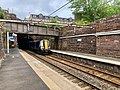
The line and platforms are about 26 feet (7.9 m) below street level,[8] in a cutting with red sandstone masonry retaining walls. The station building has a staircase down to Platform 2 (westbound), an enclosed footbridge leads across to the stair to Platform 1 (eastbound). The building is on the corner of Newton Street, which at the point it goes across the railway cutting changes direction to align with the grid plan of the west end of Greenock. From this point, the Newton Street tunnel runs directly under the street. About 920 feet (280 m) from the West Station, the tunnel goes under the older G&SWR tunnel taking that railway line down to Princes Pier. Beneath the upper end of Newton Street, where it merges into Lyle Road, the tunnel curves round towards Fort Matilda railway station.[9]
Line construction[edit]
In December 1883 both the G&SWR and the Caledonian Railway promoted competing bills to Parliament for extending their respective railways to Gourock,[10] the Caledonian's proposals were approved on 28 July 1884.[11][12]
Construction work by the contractor, Hugh Kennedy & Son, Partick, began in 1885. Buildings next to the Cathcart Street station were demolished in 1886. Work began on 11 March 1888 on the 1.2 miles (1.9 km) long tunnel under Newton Street,[13][14] connecting Greenock West to Drums near Fort Matilda, which employed thirty to forty men on each face, working day and night.[15][9] The eastern section of the line was reported completed on 3 May 1889, and on 4 May a special train took Caledonian directors over the whole route to show them the progress of the work.[16] The extension officially opened on 1 June 1889,[17][18] with the first train departing Gourock at 05:25 taking workmen to Greenock and Port Glasgow, driven by the engineer Dugald Drummond who had designed and got built the Caledonian Railway 80 Class "Coast Bogies" for the route. The first arrival at Gourock with passengers from Glasgow at 07:20 met a "warm reception".[19]
West Burn aqueduct, sugar refinery siding[edit]

The West Burn flows down adjacent to Inverkip Road, and originally powered water mills downstream from the station site,[20] where a sugar refinery originated in 1826, and was expanded by John Walker and Co from 1848.[21][22] The river was culverted under the G&SWR railway and Inverkip Street, then taken above the West Station platforms and railway line in an open metal trough forming an aqueduct leading to a reservoir or mill pond just to the north of the station.[8]
The railway cutting includes an area to the northeast of the station. A branch line diverged from the westbound track after the Duncan Street bridge and, passing to the north of columns supporting the Bruce Street bridge, curved round into a goods yard with sidings extending to West Shaw Street. A track continued into Walker's refinery.[20][21]
1912 flooding[edit]

Stormy weather followed by torrential rain on 5 August 1912 caused flooding in Greenock. From hills to its south, burns in spate contributed to a torrent down the West Burn and water running down the adjacent Inverkip Road towards Inverkip Street.[23] At Lady Alice Park on the approach to the town, the burgh corporation had put the burn in a culvert for about 400 yards (370 m), with a children's pond at its inlet, and had filled its valley to form a level playing area (bowling greens) higher than the road. Water which would have gone safely down the valley now ran down the road, increasing when the culvert inlet became blocked by debris and the pond overflowed.[24][25]
Floods built up at the West Station. Water pressure shifted the retaining wall at Platform 2 just east of the Inverkip Street bridge, damaging the westbound line and causing collapse of the gable of an adjacent bookshop with flats on upper floors. Near the foot of Inverkip Road, floodwater found an outlet into the G&SWR tunnel, and rushed down to their sidings above Brougham Street, damaging houses near Princes Pier.[23]
Both railways sued the Corporation of Greenock, in cases which set precedent for law on culverts, and on appeal the House of Lords decided the cases in favour of the railways.[24]
Developments[edit]

Walker's sugar refinery closed in 1979.[21] The Inverkip Street bridge was of steel girder construction, as the Bruce Street bridge still is, and in a similar way was extended with cast iron column supports to go over the railway sidings. It needed renewal, and in a major project after 2000 it was replaced by a modern concrete bridge and retaining wall which blocks off access to the goods yard area. The site was redeveloped as a Homebase retail outlet and car park. After this business closed, it was replaced in 2020 by The Range retailer, incorporating an Iceland food department.[26]
The mill pond was still intact in the late 1980s, but it became overgrown and its weir has been breached, letting the river flow through. The adjacent church was demolished in 2021.[27][28]
Services[edit]
It is a staffed station with two platforms; the eastbound platform to Glasgow is reached via a footbridge over the tracks. The tracks are located below street level, with a tunnel to the west leading to Fort Matilda, and to the east a cutting then a tunnel takes the line to Greenock Central. The main A78 road bridge which takes Inverkip Street over the station platforms had to be rebuilt and was closed to traffic for several years with a diversion in operation.
A busy commuter station, services at Greenock West run from around 6 am until approximately 11:30 pm; a more reduced, limited service operates on Sundays, with only one train per hour. It is near to the main Finnart Campus of the James Watt College stands nearby to the west of the station, so a large number of students use Greenock West.
| Preceding station | Following station | |||
|---|---|---|---|---|
| Fort Matilda | ScotRail Inverclyde Line |
Greenock Central | ||
| Historical railways | ||||
| Fort Matilda | Caledonian Railway Glasgow, Paisley and Greenock Railway |
Greenock Central | ||
Gallery[edit]
-
 View looking west, to station building to the left of the new road bridge and a train at the eastbound platform. The James Watt College Finnart Campus stands behind houses to the right.
 -
 The station building seen from the new road bridge, the original arched doorways converted into windows and new narrow doors formed from central window openings
 -
 View down from the new road bridge showing the footbridge, with an eastbound train
 -
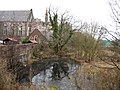 Mill pond adjacent to station
 -
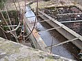 West Burn flowing in aqueduct
 -
 Train from Gourock via tunnel, arriving under aqueduct


Notes[edit]
- ^ Brailsford, Martyn, ed. (December 2017) [1987]. "Gaelic/English Station Index". Railway Track Diagrams 1: Scotland & Isle of Man (6th ed.). Frome: Trackmaps. ISBN 978-0-9549866-9-8.
- ^ McCrorie 1989, pp. 5–7.
- ^ Paterson 2001a, pp. 13–14.
- ^ a b Smith 1921, pp. 108–109.
- ^ "25" OS map, Greenock West Station to Cathcart St. Station". National Library of Scotland. 1897. Retrieved 7 June 2021.
- ^ Monteith 2004, p. 88.
- ^ Monteith, Joy (1983). Greenock from old photographs. Greenock: Inverclyde District Libraries. p. 53. ISBN 0-9500687-6-4. OCLC 863035929.
- ^ a b The Surveyor & Municipal & County Engineer. St. Bride's Press, Limited. 1917.
The Greenock Case. This law has been laid down in connection with flooding which occurred in the Burgh of Greenock on August 5, 1912 .... [G&SWR] crosses the channel of the West Burn .... the stream flowing underneath the railway in culvert. .... [Caledonian Railway] crosses under the West Burn in an open cutting about 26 ft. deep, in which Greenock West Station is situated . The stream is carried over the railway and station in an open trough .... and through a mill pond into which the trough discharges.
- ^ a b "25" OS map, Fort Matilda to Greenock West Station". National Library of Scotland. 1897. Retrieved 7 June 2021.
- ^ Smith 1921, p. 108.
- ^ McCrorie 1989, p. 8.
- ^ Bradshaw's Railway Manual, Shareholders' Guide, and Official Directory for 1889. W. J. Adams. 1889. p. 32.
- ^ Monteith 2004, pp. 40, 48, 70, 94.
- ^ "Glasgow Railways: a chronology – 1880s". 3 May 2007. Archived from the original on 3 May 2007. Retrieved 10 May 2022.
- ^ Monteith 2004, p. 70.
- ^ Paterson 2001b, pp. 42–43.
- ^ Monteith 2004, pp. 70, 84.
- ^ Monteith & MacDougall 1981, pp. 20–21.
- ^ Paterson 2001b, p. 43.
- ^ a b "Side by side georeferenced maps viewer - OS 6" 1857, 25" 1896". National Library of Scotland. 8 May 2021. Retrieved 12 June 2021.
- ^ a b c Anderson & Monteith 1980, p. 39.
- ^ "Greenock, Nicolson Street And West Shaw Street, Walker's Sugar Refinery". Canmore. Retrieved 12 June 2021.
- ^ a b Maclean, Sandy (2010). "The Greenock Railway Flooding Monday 5th August 1912" (PDF). Scottish Transport, Annual Magazine of The Scottish Tramway & Transport Society (62). Glasgow: Scottish Tramway and Transport Society: 4–12. Retrieved 12 June 2021.
- ^ a b "Corporation of Greenock v Caledonian Railway Company: HL 1917". swarb.co.uk. 19 July 2020. Retrieved 20 June 2021.
"Glasgow & South-Western Railway v. Greenock Corporation 1917; UKHL 600 (23 July 1917)". LawCareNigeria. 4 March 2020. Retrieved 20 June 2021. - ^ "Side by side georeferenced maps viewer - OS 25" 1896, 1:1250 1964". National Library of Scotland. 9 May 2021. Retrieved 20 June 2021.
- ^ "Major Retailer The Range Opening Its New Greenock Store". Inverclyde Now. 4 June 2020. Retrieved 13 June 2021.
- ^ "In Pictures - Views Of Greenock Town Centre's 'Hidden Oasis' From The Late 1980s". Inverclyde Now. 11 June 2021. Retrieved 13 June 2021.
- ^ "In Pictures - Demolition Of Old Greenock Church Continues". Inverclyde Now. 3 March 2021. Retrieved 13 June 2021.
References[edit]
- Anderson, Matt; Monteith, Joy (1980). Greenock from old photographs. Greenock: Inverclyde District Libraries. ISBN 0-9500687-1-3. OCLC 863035956.
- McCrorie, Ian (1989). To The Coast. Fairlie, Ayrshire: Fairlie Press. ISBN 1-8712-0901-3.
- Monteith, Joy; MacDougall, Sandra (1981). Gourock, Inverkip and Wemyss Bay. Greenock: Inverclyde District Libraries. ISBN 0-9500687-2-1.
- Monteith, Joy (2004). Old Greenock. Catrine, Ayrshire: Stenlake Publishing. ISBN 978-1-84033-314-5. Archived from the original on 18 February 2015. Retrieved 14 June 2021.
- Paterson, Alan (2001a). The Victorian summer of the Clyde steamers (1864-1888). Edinburgh: John Donald. ISBN 978-0-85976-550-3. OCLC 51991825.
- Paterson, Alan (2001b). The golden years of the Clyde steamers (1889-1914). Edinburgh: Birlinn. ISBN 978-0-85976-551-0. OCLC 51669373.
- Smith, R.M. (1921). The History of Greenock. Greenock: Orr, Pollock & Co. (Inverclyde Council website)
External links[edit]
- Train times and station information for Greenock West railway station from National Rail
- Video footage of Greenock West
![]() Media related to Greenock West railway station at Wikimedia Commons
Media related to Greenock West railway station at Wikimedia Commons