
Putanges-le-Lac
Putanges-le-Lac | |
|---|---|
 Putanges centre from across the river | |
Location of Putanges-le-Lac  | |
 Putanges-le-Lac  Putanges-le-Lac | |
| Coordinates: 48°45′47″N 0°14′53″W / 48.763°N 0.248°W | |
| Country | France |
| Region | Normandy |
| Department | Orne |
| Arrondissement | Argentan |
| Canton | Athis-Val de Rouvre |
| Intercommunality | Val d'Orne |
| Government | |
| • Mayor (2020–2026) | Sébastien Leroux[1] |
| Area 1 | 76.91 km2 (29.70 sq mi) |
| Population (2021)[2] | 2,125 |
| • Density | 28/km2 (72/sq mi) |
| Time zone | UTC+01:00 (CET) |
| • Summer (DST) | UTC+02:00 (CEST) |
| INSEE/Postal code | 61339 /61210 |
| 1 French Land Register data, which excludes lakes, ponds, glaciers > 1 km2 (0.386 sq mi or 247 acres) and river estuaries. | |
Putanges-le-Lac (French pronunciation: [pytɑ̃ʒ lə lak]) is a commune in the department of Orne, northwestern France. The municipality was established on 1 January 2016 by merger of the former communes of Chênedouit, La Forêt-Auvray, La Fresnaye-au-Sauvage, Ménil-Jean, Putanges-Pont-Écrepin (the seat), Rabodanges, Les Rotours, Saint-Aubert-sur-Orne and Sainte-Croix-sur-Orne.[3]
Geography[edit]
The commune is part of the area known as Suisse Normande.[4]
The commune is made up of the following collection of villages and hamlets, Putanges-Pont-Écrepin,La Ferronnière, La Forêt-Auvray, Saint-Aubert-sur-Orne,Rabodanges,Les Rotours, Méguillaume, Chênedouit, Sainte-Croix-sur-Orne, La Fresnaye-au-Sauvage, Ménil-Jean and Fromentel.
The river Orne runs through the commune, along with five streams which are all one of the Orne's tributaries, Vienne, la Guesnerie, Gue Blandin, Monts Hiboux and Ruisseau des Vallees.[5] There is one more stream the Maufy which feeds into the Rouvre.[6]
Population[edit]
| Year | Pop. | ±% p.a. |
|---|---|---|
| 1968 | 2,381 | — |
| 1975 | 2,179 | −1.26% |
| 1982 | 2,155 | −0.16% |
| 1990 | 2,118 | −0.22% |
| 1999 | 2,069 | −0.26% |
| 2007 | 2,178 | +0.64% |
| 2012 | 2,156 | −0.20% |
| 2017 | 2,181 | +0.23% |
| Source: INSEE[7] | ||
Notable buildings and places[edit]
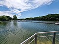
- Lac de Rabodanges is a 6 km artificial lake covering almost 240 acres, making it the largest lake in Lower Normandy.[8] It was created in 1960 after completion of building a dam at Rabodanges. The dam is 160 meters long and 17 metres high holding back 6 million cubic meters of water.[9] The lake is now a popular tourist destination and had a designated swimming area opened in August 2022.[10]
-
 Rabodanges Lac
 -
 Lac de Rabodanges Swimming area


National heritage sites[edit]
The Commune has 6 buildings and areas listed as a Monument historique.
Manoir de la Cour is a 15th-century manor house in Saint-Aubert-sur-Orne with later additions added in the 17th century, classed as a Monument historique in 2011.[13]
Former village of Vieux-Saint-Aubert the remains of a village in Saint-Aubert-sur-Orne with buildings dated from the 12th and 14th century, that was registered as a Monument Historique in 1992.[14]
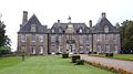
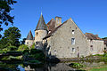
Château de Rabodanges is a 17th-century chateau built in place of a feudal castle destroyed in 1628 by order of Cardinal Richelieu. It is based in Rabodanges and in 1981 was classed as a Monument Historique [15]
Château of la Forêt-Auvray is a 16th-century Huguenots fort, which in 2002 was registered as a Monument Historique.[16]
Château du Meal is a 17th-century chateau in Chênedouit registered as a Monument historique in 1967.[17]
La Droite Pierre Menhir is a Neolithic Menhir based in Chênedouit was classed as a Monument Historique in 1981.[18]
-
 Chateau du repas
 -
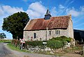
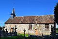 Chapelle Saint-Malo de la Fresnaye-au-Sauvage
 -
 Rabodanges Chateau
 -
 Église Notre-Dame-de-l'Assomption des Rotours
 -
 Manoir de Sainte-Croix-sur-Orne
 -
 Putanges mairie
 -
 Chapelle Sainte-Geneviève de Putanges-Pont-Écrepin
 -
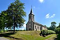
 Église Notre-Dame de Méguillaume


.jpg)

Notable People[edit]
- Charles-François Toustain a French historian and a member of the Benedictine Congregation of Saint Maur was born in Le Repas in 1700.[19]
- Jean Vauquelin de la Fresnaye a French poet born at the château of La Fresnaye-au-Sauvage in 1536.[20]
- Robert d'Aguiló a Norman Knight born c.1100AD in Rabodanges.[21]
- Guillaume-René Lefébure a French military, historian, physician, political writer and man of letters born in 1744 at Sainte-Croix-sur-Orne.[22]
- Robert Guérin du Rocher a Jesuit priest, who was beatified by Pope Pius XI in October 1926, was born in Repas.[23]
See also[edit]
References[edit]
- ^ "Répertoire national des élus: les maires" (in French). data.gouv.fr, Plateforme ouverte des données publiques françaises. 13 September 2022.
- ^ "Populations légales 2021". The National Institute of Statistics and Economic Studies. 28 December 2023.
- ^ Arrêté préfectoral 26 November 2015 (in French)
- ^ "Map of Suiss Normande" (PDF).
- ^ Sandre. "Fiche cours d'eau - L'Orne (I2--0200)".
- ^ Sandre. "Fiche cours d'eau - La Rouvre (I23-0400)".
- ^ Population en historique depuis 1968, INSEE
- ^ "Lac de Rabodanges PUTANGES-LE-LAC : Normandy Tourism". en.normandie-tourisme.fr.
- ^ "Lac de Rabodanges". www.office-tourisme-putanges.com.
- ^ "Putanges-le-Lac. La baignade au lac de Rabodanges est lancée pour sa première saison". www.ouest-france.fr.
- ^ "61210 La Forêt-Auvray : Pierre de la Rousselière". 61.monvillagenormand.fr.
- ^ "Pierre de la Roussellière - Standing Stone (Menhir) in France in Normandie:Orne (61)". The Megalithic Portal.
- ^ "Manoir de la Cour à Putanges-le-Lac - PA61000061". monumentum.fr.
- ^ "Ancien village du Vieux-Saint-Aubert à Putanges-le-Lac - PA00111001". monumentum.fr.
- ^ "Château à Putanges-le-Lac - PA00110894". monumentum.fr.
- ^ "Château de la Forêt-Auvray à Putanges-le-Lac - PA61000027". monumentum.fr.
- ^ "Château du Repas à Putanges-le-Lac - PA00110775". monumentum.fr.
- ^ "Menhir dénommé La Droite Pierre à Putanges-le-Lac - PA00110776". monumentum.fr.
- ^ "CATHOLIC ENCYCLOPEDIA: Charles-Francois Toustain". www.newadvent.org.
- ^ "Jean Vauquelin de La Fresnaye, sieur (lord) des Yveteaux". Britannica. Retrieved 24 September 2022.
- ^ "FULLS DE CULTURA - CARRER ROBERT D'AGUILÓ".
- ^ "Le Fébure, Guillaume-René (1744-1809)".
- ^ "Den salige Robert Guérin du Rocher (1736-1792)". Den katolske kirke.
Neighbouring communes[1] | |
|---|---|
- ^ "Putanges-le-Lac · 61210, France". Putanges-le-Lac · 61210, France.