Chemilli
Chemilli | |
|---|---|
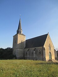
 The church in Chemilli | |
| Coordinates: 48°21′52″N 0°26′41″E / 48.3644°N 0.4447°E | |
| Country | France |
| Region | Normandy |
| Department | Orne |
| Arrondissement | Mortagne-au-Perche |
| Canton | Ceton |
| Intercommunality | Collines du Perche Normand |
| Government | |
| • Mayor (2020–2026) | Anthony Savale[1] |
| Area 1 | 10.92 km2 (4.22 sq mi) |
| Population (2021)[2] | 176 |
| • Density | 16/km2 (42/sq mi) |
| Time zone | UTC+01:00 (CET) |
| • Summer (DST) | UTC+02:00 (CEST) |
| INSEE/Postal code | 61105 /61360 |
| Elevation | 93–143 m (305–469 ft) (avg. 107 m or 351 ft) |
| 1 French Land Register data, which excludes lakes, ponds, glaciers > 1 km2 (0.386 sq mi or 247 acres) and river estuaries. | |
Chemilli (French pronunciation: [ʃəmiji] ⓘ) is a commune in the Orne department in north-western France.
Notable buildings and places[edit]
The Montperthuis Gardens is a garden that was opened to the public in 2015, and features over 300 varieties of Roses.[3] The garden is classed as a Jardins remarquables by the Ministry of Culture and the Comité des Parcs et Jardins de France.[4]
See also[edit]
References[edit]
- ^ "Répertoire national des élus: les maires". data.gouv.fr, Plateforme ouverte des données publiques françaises (in French). 9 August 2021.
- ^ "Populations légales 2021". The National Institute of Statistics and Economic Studies. 28 December 2023.
- ^ "Chemilli : Philippe Dubreuil a de nombreux projets pour les jardins du Montperthuis". actu.fr. 29 January 2023.
- ^ "Les jardins de Montperthuis - Comité des Parcs et Jardins de France". www.parcsetjardins.fr.
Wikimedia Commons has media related to Chemilli.


