Ginai
Ginai | |
|---|---|
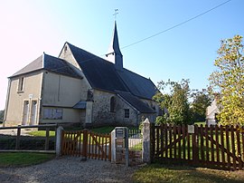
 The church in Ginai | |
| Coordinates: 48°44′52″N 0°13′06″E / 48.7478°N 0.2183°E | |
| Country | France |
| Region | Normandy |
| Department | Orne |
| Arrondissement | Argentan |
| Canton | Argentan-2 |
| Intercommunality | Argentan Intercom |
| Government | |
| • Mayor (2020–2026) | Michel Buon[1] |
| Area 1 | 9.25 km2 (3.57 sq mi) |
| Population (2021)[2] | 71 |
| • Density | 7.7/km2 (20/sq mi) |
| Time zone | UTC+01:00 (CET) |
| • Summer (DST) | UTC+02:00 (CEST) |
| INSEE/Postal code | 61190 /61310 |
| Elevation | 182–268 m (597–879 ft) (avg. 320 m or 1,050 ft) |
| 1 French Land Register data, which excludes lakes, ponds, glaciers > 1 km2 (0.386 sq mi or 247 acres) and river estuaries. | |
Ginai (French pronunciation: [ʒinɛ] ⓘ) is a commune in the Orne department in north-western France.
Geography[edit]
The commune is made up of the following collection of villages and hamlets, La Briquetière, Les Bruyères and Ginai.[3]
The River Ure runs through the commune in addition to a single stream, the Roule-Crottes.
Notable buildings and places[edit]
National heritage sites[edit]
- Hippodrome de Bergerie a racecourse that is owned by the Haras du Pin.[4] It hosted Normandy's first gallop race in 1851.[4] In 1863 it was inaugurated in 1863 by Napoleon III.[5] It was classed as a Monument historique.[6]
See also[edit]
References[edit]
- ^ "Répertoire national des élus: les maires". data.gouv.fr, Plateforme ouverte des données publiques françaises (in French). 2 December 2020.
- ^ "Populations légales 2021". The National Institute of Statistics and Economic Studies. 28 December 2023.
- ^ a b "Ginai · 61310, France". Ginai · 61310, France.
- ^ a b FOUREY, Danièle (8 October 2022). "Ginai. Des courses à l'hippodrome de la Bergerie, les dimanches 9 et 23 octobre". Ouest-France.fr.
- ^ BERRE, Tiphaine LE (26 August 2022). "Près d'Argentan. Inauguré par Napoléon en 1863, l'hippodrome de la Bergerie sera entouré de cabanes". Ouest-France.fr.
- ^ "Haras national du Pin (également sur communes de La Cochère, Ginai et Exmes) au Pin-au-Haras - PA00110888". monumentum.fr.
Wikimedia Commons has media related to Ginai.


