Portal:Utah
The Utah Portal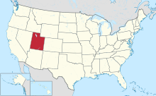  Utah (/ˈjuːtɑː/ YOO-tah, /ˈjuːtɔː/ ⓘ YOO-taw; Navajo: Áshįįh Biiʼtó Hahoodzo) is a landlocked state in the Mountain West subregion of the Western United States. It borders Colorado to its east, Wyoming to its northeast, Idaho to its north, Arizona to its south, and Nevada to its west. Utah also touches a corner of New Mexico in the southeast. Of the fifty U.S. states, Utah is the 13th-largest by area; with a population over three million, it is the 30th-most-populous and 11th-least-densely populated. Urban development is mostly concentrated in two areas: the Wasatch Front in the north-central part of the state, which is home to roughly two-thirds of the population and includes the capital city, Salt Lake City; and Washington County in the southwest, with more than 180,000 residents. Most of the western half of Utah lies in the Great Basin. Utah has been inhabited for thousands of years by various indigenous groups such as the ancient Puebloans, Navajo, and Ute. The Spanish were the first Europeans to arrive in the mid-16th century, though the region's difficult geography and harsh climate made it a peripheral part of New Spain and later Mexico. Even while it was Mexican territory, many of Utah's earliest settlers were American, particularly Mormons fleeing marginalization and persecution from the United States via the Mormon Trail. Following the Mexican–American War in 1848, the region was annexed by the U.S., becoming part of the Utah Territory, which included what is now Colorado and Nevada. Disputes between the dominant Mormon community and the federal government delayed Utah's admission as a state; only after the outlawing of polygamy was it admitted in 1896 as the 45th. People from Utah are known as Utahns. Slightly over half of all Utahns are Mormons, the vast majority of whom are members of the Church of Jesus Christ of Latter-day Saints (LDS Church), which has its world headquarters in Salt Lake City; Utah is the only state where a majority of the population belongs to a single church. The LDS Church greatly influences Utahn culture, politics, and daily life, though since the 1990s the state has become more religiously diverse as well as secular. (Full article...) Entries here consist of Good and Featured articles, which meet a core set of high editorial standards.
 Wendover Air Force Base is a former United States Air Force base in Utah now known as Wendover Airport. During World War II, it was a training base for B-17 and B-24 bomber crews. It was the training site of the 509th Composite Group, the B-29 unit that carried out the atomic bombings of Hiroshima and Nagasaki. After the war, Wendover was used for training exercises, gunnery range and as a research facility. It was closed by the Air Force in 1969, and the base was given to Wendover City in 1977. Tooele County, Utah, assumed ownership of the airport and base buildings in 1998, and the County continues to operate the airfield as a public airport. A portion of the original bombing range is now the Utah Test and Training Range (UTTR) which is used extensively by the Air Force with live fire targets on the range. (Full article...)Selected image - West Mitten Butte Monument Valley, view northeastward from Arizona to Utah
April selected anniversaries
Selected biography -
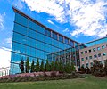
Franklin Stewart Harris (August 29, 1884 – April 18, 1960) was president of Brigham Young University (BYU) from July 1921 until June 1945, and president of Utah State University from 1945 to 1950. His administration was the longest in BYU history and saw the granting of the first master's degrees. Under his administration the school became an accredited university. He set up several colleges, such as the College of Fine and Performing Arts with Gerrit De Jong as the founding dean. Harris was an agricultural scientist, holding a doctorate in agronomy from Cornell University. He had served as the agriculture department head and head of the experiment station at Utah State Agricultural College and left BYU to become president of that institution. Harris also traveled to Russia and to Iran and other parts of the Middle East in order to provide expert advice on agriculture issues. The Harris Fine Arts Center on BYU's Provo campus was named after him. (Full article...)
Selected article -Salt Lake City, often shortened to Salt Lake or SLC, is the capital and most populous city of the U.S. state of Utah. It is the seat of Salt Lake County, the most populous county in the state. The city is the core of the Salt Lake City Metropolitan Statistical Area (MSA), which had a population of 1,257,936 at the 2020 census. Salt Lake City is further situated within a larger metropolis known as the Salt Lake City–Ogden–Provo Combined Statistical Area, a corridor of contiguous urban and suburban development stretched along a 120-mile (190 km) segment of the Wasatch Front, comprising a population of 2,746,164 (as of 2021 estimates), making it the 22nd largest in the nation. With a population of 200,133 in 2020, it is the 117th most populous city in the United States. It is also the central core of the larger of only two major urban areas located within the Great Basin (the other being Reno, Nevada). Salt Lake City was founded on July 24, 1847, by early pioneer settlers led by Brigham Young who were seeking to escape persecution they had experienced while living farther east. The Mormon pioneers, as they would come to be known, entered a semi-arid valley and immediately began planning and building an extensive irrigation network which could feed the population and foster future growth. Salt Lake City's street grid system is based on a standard compass grid plan, with the southeast corner of Temple Square (the area containing the Salt Lake Temple in downtown Salt Lake City) serving as the origin of the Salt Lake meridian. Owing to its proximity to the Great Salt Lake, the city was originally named Great Salt Lake City. In 1868, the word "Great" was dropped from the city's name. Immigration of international members of the Church of Jesus Christ of Latter-day Saints (LDS Church), mining booms, and the construction of the first transcontinental railroad brought economic growth, and the city was nicknamed "The Crossroads of the West". It was traversed by the Lincoln Highway, the first transcontinental highway, in 1913. Two major cross-country freeways, I-15 and I-80, now intersect in the city. The city also has a belt route, I-215. (Full article...)Did you know -
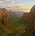
Selected panorama - Moab, Utah, from the northern canyon walls that surround it.
TopicsCategoriesGeneral imagesThe following are images from various Utah-related articles on Wikipedia.
State facts
State symbols:
Featured contentArticles:
Lists:
Pictures: Related portals
Lists
Related WikiProjectsNew articlesThis list was generated from these rules. Questions and feedback are always welcome! The search is being run daily with the most recent ~14 days of results. Note: Some articles may not be relevant to this project.
Rules | Match log | Results page (for watching) | Last updated: 2024-04-30 22:10 (UTC) Note: The list display can now be customized by each user. See List display personalization for details.
Things you can doAssociated WikimediaThe following Wikimedia Foundation sister projects provide more on this subject:
Discover Wikipedia using portals |


