Portal:Arizona
| Showcase | Content |
Welcome to the Arizona portal!
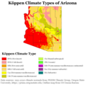
Arizona (/ˌærɪˈzoʊnə/ ⓘ ARR-ih-ZOH-nə; Navajo: Hoozdo Hahoodzo [hoː˥z̥to˩ ha˩hoː˩tso˩]; O'odham: Alĭ ṣonak [ˈaɭi̥ ˈʂɔnak]) is a landlocked state in the Southwestern region of the United States. Arizona is part of the Four Corners region with Utah to the north, Colorado to the northeast, and New Mexico to the east; its other neighboring states are Nevada to the northwest, California to the west and the Mexican states of Sonora and Baja California to the south and southwest. It is the 6th-largest and the 14th-most-populous of the 50 states. Its capital and largest city is Phoenix. Arizona is the 48th state and last of the contiguous states to be admitted to the Union, achieving statehood on February 14, 1912. Historically part of the territory of Alta California and Nuevo México in New Spain, it became part of independent Mexico in 1821. After being defeated in the Mexican–American War, Mexico ceded much of this territory to the United States in 1848, where the area became part of the territory of New Mexico. The southernmost portion of the state was acquired in 1853 through the Gadsden Purchase. Southern Arizona is known for its desert climate, with very hot summers and mild winters. Northern Arizona features forests of pine, Douglas fir, and spruce trees; the Colorado Plateau; mountain ranges (such as the San Francisco Mountains); as well as large, deep canyons, with much more moderate summer temperatures and significant winter snowfalls. There are ski resorts in the areas of Flagstaff, Sunrise, and Tucson. In addition to the internationally known Grand Canyon National Park, which is one of the world's seven natural wonders, there are several national forests, national parks, and national monuments. Arizona is home to a diverse population. About one-quarter of the state is made up of Indian reservations that serve as the home of 27 federally recognized Native American tribes, including the Navajo Nation, the largest in the state and the country, with more than 300,000 citizens. Since the 1980s, the proportion of Hispanics has grown significantly owing to migration from Mexico. A substantial portion of the population are followers of the Roman Catholic Church and the Church of Jesus Christ of Latter-day Saints. Arizona's population and economy have grown dramatically since the 1950s because of inward migration, and the state is now a major hub of the Sun Belt. Cities such as Phoenix and Tucson have developed large, sprawling suburban areas. Many large companies, such as PetSmart and Circle K, have headquarters in the state, and Arizona is home to major universities, including the University of Arizona and Arizona State University. The state is known for a history of conservative politicians such as Barry Goldwater and John McCain, though it has become a swing state since the 1990s. (Full article...) Selected article - The known human history of the Grand Canyon area stretches back 10,500 years, when the first evidence of human presence in the area is found. Native Americans have inhabited the Grand Canyon and the area now covered by Grand Canyon National Park for at least the last 4,000 of those years. Ancestral Pueblo peoples, first as the Basketmaker culture and later as the more familiar Pueblo people, developed from the Desert Culture as they became less nomadic and more dependent on agriculture. A similar culture, the Cochimi also lived in the canyon area. Drought in the late 13th century likely caused both groups to move on. Other people followed, including the Paiute, Cerbat, and the Navajo, only to be later forced onto reservations by the United States Government. In September 1540, under direction by conquistador Francisco Vásquez de Coronado to find the fabled Seven Cities of Gold, Captain García López de Cárdenas led a party of Spanish soldiers with Hopi guides to the Grand Canyon. More than 200 years passed before two Spanish priests became the second party of non-Native Americans to see the canyon. U.S. Army Major John Wesley Powell led the 1869 Powell Geographic Expedition through the canyon on the Colorado River. This and later study by geologists uncovered the geology of the Grand Canyon area and helped to advance that science. In the late 19th century, the promise of mineral resources—mainly copper and asbestos—renewed interest in the region. The first pioneer settlements along the rim came in the 1880s. (Full article...)Did you know (auto-generated) -
Selected picture -
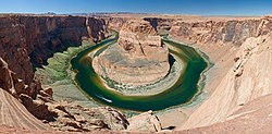
A panoramic view of Horseshoe Bend, a horseshoe-shaped meander in the Colorado River, from State Route 89. It is located approximately 4 miles (6.4 km) south of Page, Arizona, slightly downstream from the Glen Canyon Dam and Lake Powell. More did you know -
WikiProjects
Selected biography -Wyatt Berry Stapp Earp (March 19, 1848 – January 13, 1929) was an American lawman and gambler in the American West, including Dodge City, Deadwood, and Tombstone. Earp was involved in the famous gunfight at the O.K. Corral, during which lawmen killed three outlaw Cochise County Cowboys. While Wyatt is often depicted as the key figure in the shootout, his brother Virgil was both Deputy U.S. Marshal and Tombstone City Marshal that day and had considerably more experience in law enforcement as a sheriff, constable, and marshal than did Wyatt. Virgil made the decision to enforce a city ordinance prohibiting carrying weapons in town and to disarm the Cowboys. Wyatt was only a temporary assistant marshal to his brother. In 1874, Earp arrived in the boomtown of Wichita, Kansas, where his reputed wife opened a brothel. Wyatt was arrested more than once for his presence in a brothel where he may have been a pimp. He was later appointed to the Wichita police force and developed a solid reputation as a lawman but was fined and "not rehired as a police officer" after getting into a physical altercation with a political opponent of his boss. Earp immediately left Wichita, following his brother James to Dodge City, Kansas where his brother's wife Bessie and Earp's common-law wife Sally operated a brothel. He later became an assistant city marshal. In late 1878, he went to Texas to track down an outlaw, the infamous "Dirty Dave" Rudabaugh, and met John "Doc" Holliday, whom Earp credited with saving his life. (Full article...)General images -The following are images from various Arizona-related articles on Wikipedia.
News
Wikinews Arizona portal
CategoriesRelated portalsTopicsState facts
State symbols:
Recognized content
Featured articles
Featured lists
Good articles
Featured pictures
Things you can doAssociated WikimediaThe following Wikimedia Foundation sister projects provide more on this subject:
Discover Wikipedia using portals | |||||||||||||||||


