
Wikipedia:Reference desk/Archives/Miscellaneous/2007 June 6
| Miscellaneous desk | ||
|---|---|---|
| < June 5 | << May | June | Jul >> | June 7 > |
| Welcome to the Wikipedia Miscellaneous Reference Desk Archives |
|---|
| The page you are currently viewing is an archive page. While you can leave answers for any questions shown below, please ask new questions on one of the current reference desk pages. |
June 6[edit]
Copyright status of Neue Liszt-Ausgabe[edit]
Over at IMSLP.org, I am collecting the works of Franz Liszt. There are many editions to choose from, one critical edition of Liszt collected works is Neue Liszt-Ausgabe. However, this edition is very recent but it might be "scholary" (hence, pre-1982 editions are public domain in Canada [Berne rule] were IMSLP's server is hosted). What is the copyright status of Neue Liszt-Ausgabe? Does it fall under the Berne rule of shorter term? Is it a scientific edition? Is it published by Bärenreiter or Editio Musica Budapest? Is it public domain in Canada (which is a member of Berne)? Is it OK to typeset from Neue Liszt-Ausgabe? --Funper 00:03, 6 June 2007 (UTC)
- I would think only the publisher is in a position to give you the definite (and legally binding) answer that you need. I suggest you put your questions directly to Bärenreiter and Editio Musica Budapest.--Shantavira|feed me 09:16, 6 June 2007 (UTC)
- One week now, they haven't answered yet.. --Funper 17:28, 6 June 2007 (UTC)
- Most places don't. They don't want to give up copies to other people - and if they are on shakey ground, they find it's better to shut up than to enter into a debate. SteveBaker 02:24, 8 June 2007 (UTC)
- Hmm, maybe something is into it ("shakey grounds") since Bärenreiter and Edition Musica Budapest both worked jointly on Neue Liszt-Ausgabe, which atleast would render any pre-1982 publications as public domain if it turns out that Bärenreiter has a part in publishing. I will try with one more email to them both. Also, please take a look here: [1] but I don't believe him since everything regarding Neue Liszt Ausgabe is kind of mysterious. --Funper 21:30, 8 June 2007 (UTC)
- Nope still no answer. Could somebody please fill in what Edition Musica Budapest is leaving out? --Funper 19:50, 10 June 2007 (UTC)
- Hmm, maybe something is into it ("shakey grounds") since Bärenreiter and Edition Musica Budapest both worked jointly on Neue Liszt-Ausgabe, which atleast would render any pre-1982 publications as public domain if it turns out that Bärenreiter has a part in publishing. I will try with one more email to them both. Also, please take a look here: [1] but I don't believe him since everything regarding Neue Liszt Ausgabe is kind of mysterious. --Funper 21:30, 8 June 2007 (UTC)
- Most places don't. They don't want to give up copies to other people - and if they are on shakey ground, they find it's better to shut up than to enter into a debate. SteveBaker 02:24, 8 June 2007 (UTC)
- One week now, they haven't answered yet.. --Funper 17:28, 6 June 2007 (UTC)
Driving Directions[edit]
I'd like to know why that I can get different results for Milage and times from different driving directions websites.
For example:
Milwaukee, WI to Marquette, MI
Yahoo: 290.9 Miles and 4 hrs 52 mins Mapquest: 290.5 Miles and 5 hrs 16 mins Rand Mcnally: 291 miles and 5 hrs 20 mins
The milage is almost identical, but the timing is almost 1/2 hour different. Why is that?
- This could be because of many reasons. The time it estimates you will take will be calculated in different ways. eg: one could assume you are going to travel an average of 30mph for the entire journey, and thus . So one site may calculate it this very simple way, and another may calculate it by adding lots of little distances and speeds together, so it might know the speed limit on a certain road, so add the time for that, to another road, and another. Another way to calculate time may be to work out the time, and then for every junction add a bit more on. Obviously the way time is calculated can be incredibly complicated, or incredibly simple, but there is clearly a lot of room for significant differences in results. 87.194.40.165 03:10, 6 June 2007 (UTC)
- There may be time factored in for fuel stops as well. One site may assume that you are going to drive the speed limit the whole way while another may assume that the average driver is going to go a couple mph over the posted speed limit. They're all making a prediction on what they believe is the "average" driver. Average probably has different meanings to each of the sites. Dismas|(talk) 06:26, 6 June 2007 (UTC)

- The differences in mileage can be much greater than you have found for these two points. This is because each site has different route-finding software. Some software will always choose interstate highways over other roads, which can lead to greater mileages, or one will make different assumptions about average speed and decide on a different "fastest" route than a competing route finder. Since your distances are so close, I am guessing that all three route finders chose essentially the same route, but they may have differed slightly on the start and end points (if you did not specify addresses in those cities) or on the calculation of distances along that route. This could be something as simple as one route finder accounting for the added distance involved in making lane changes, or it might be that one has maps that show curves more accurately than the other. Marco polo 12:52, 6 June 2007 (UTC)
- The mileage may also vary because little things can add up. For example, simply adding (or not) the mileage of the ramps in all the highway interchanges can have a noticeable effect on the overall route mileage. You can often see this if you measure the mileage in both directions on the same trip. The mileage in the direction where you (by chance) travelled the "inner" ramps of all the cloverleaf intersections might be as much as a mile shorter than the direction where you travelled all the "cloverleaf" ramps of the intersections. Various mapping programs might take this into account or not. This effect is significant enough to be obvious even on my daily commute.
- Atlant 12:57, 6 June 2007 (UTC)
- There are many further sources of discrepancies between the measurements: differing map projections or datums, the quality and precision of the transportation dataset used—some may have a finer representation, more line segments used to model sections of roads (the map scale of the dataset), and some of the route finding algorithms might take into account the differences in elevation along the path while others do not. There are quite a few sources of error when calculating the distance of a wavy path running on a curved, bumpy, and rough surface such as Earth's. There are bound to be differences in measurement when different algorithms are used.—eric 05:40, 7 June 2007 (UTC)
- You really need to re-read the question. The distances reported by the various tools were very similar - so none of the things you describe were a significant matter. The question is: Why (if the distances are virtually identical) do the travel times differ by such a huge amount? The answer can only be the assumed speed at which each of the systems estimate you'll be able to drive. Nothing else can account for the discrepancy....hence my answer below. SteveBaker 02:21, 8 June 2007 (UTC)
- Hmm: "...why that I can get different results for Milage and times..." Seems they were asking why both measurements differed, though after rereading my response i could have made it clearer that it was only a partial answer.—eric 04:07, 8 June 2007 (UTC)
- You really need to re-read the question. The distances reported by the various tools were very similar - so none of the things you describe were a significant matter. The question is: Why (if the distances are virtually identical) do the travel times differ by such a huge amount? The answer can only be the assumed speed at which each of the systems estimate you'll be able to drive. Nothing else can account for the discrepancy....hence my answer below. SteveBaker 02:21, 8 June 2007 (UTC)
- There are many further sources of discrepancies between the measurements: differing map projections or datums, the quality and precision of the transportation dataset used—some may have a finer representation, more line segments used to model sections of roads (the map scale of the dataset), and some of the route finding algorithms might take into account the differences in elevation along the path while others do not. There are quite a few sources of error when calculating the distance of a wavy path running on a curved, bumpy, and rough surface such as Earth's. There are bound to be differences in measurement when different algorithms are used.—eric 05:40, 7 June 2007 (UTC)
- I'm guessing that the speed limit changed on one of the roads on the route and one of the services is out of date and using the old data. I also suspect (but don't know for sure) that some route finders have data on typical traffic densities on these roads - so they may be using average practical speeds rather than the speed limit. However, if I'm right then I'm a little surprised that these sites aren't asking what time/day you plan to travel. SteveBaker 11:34, 7 June 2007 (UTC)
GNAA and Wikipedia Red Faction[edit]
Why doesn't Wikipedia allow articles for those groups? I wanted to know more about them but the only thing I know is that the first one is something like a trolling organization. --Taraborn 12:03, 6 June 2007 (UTC)
- Here's the discussion on keeping versus deleting the article on GNAA: Wikipedia:Articles_for_deletion/Gay_Nigger_Association_of_America. ---77.56.100.189 12:47, 6 June 2007 (UTC)
- Thanks. I've read the whole discussion. --85.50.128.17 19:01, 6 June 2007 (UTC)
pacific[edit]
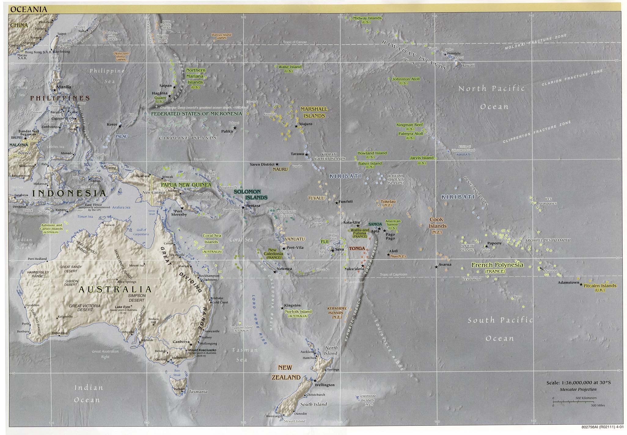
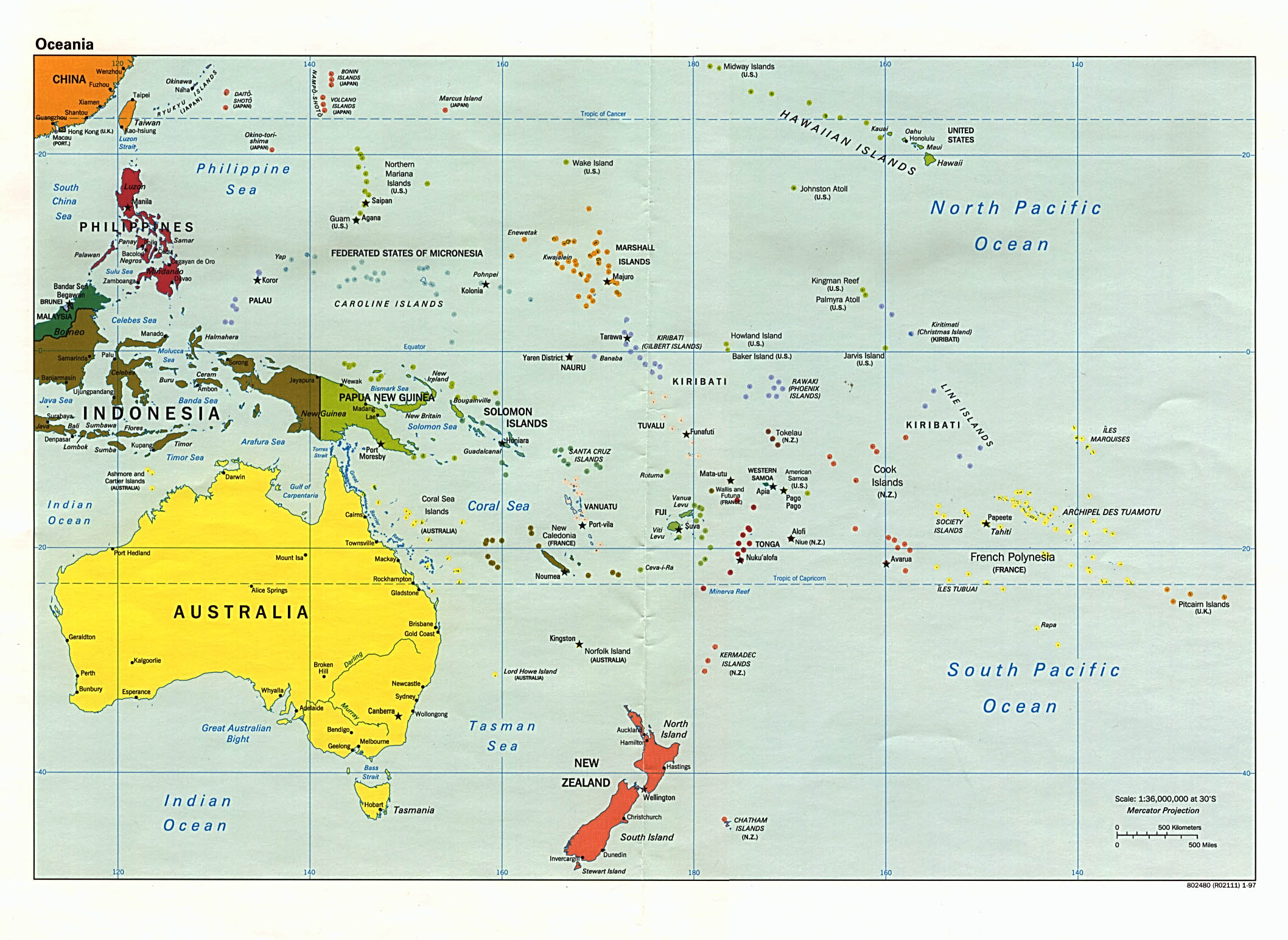
Where (on the internet) can I find a map which clearly shows the islands of the pacific ocean, so that each island can be identified but where they are all still on the same scale as the ocean around them?
- This is pretty good size (I started googling for "large pacific ocean map" and related terms), but you should bear in mind that clear identification and proper scale are often mutually exclusive when it comes to small islands in the middle of the ocean. — Lomn 14:46, 6 June 2007 (UTC)
- This is probably the best one at Wikimedia Commons (Category:Maps of the Pacific Ocean). But it's fron 1906 and in German.
So there aren't any maps with the sea in one colour and the land another, and nothing else? Is there anywhere on the internet I can go to find lots of maps like this, and see which is best?
- I'm sure they're out there (start googling!), but as I noted above, you're going to see blue. Here is a larger one (it allows you to see the dots under the highlighting, which should aid in appreciating the scale), but even then, I remain skeptical that the smaller islands are correctly proportioned, even as dots. Note that Google has a "large images" filter when image searching. — Lomn 15:25, 6 June 2007 (UTC)
The trouble is that the pacific is HUGE and some of the islands are TINY - so you are are really asking for two contradictory things - if portrayed at true scale, small islands are very small indeed compared to the ocean, so they aren't going to be clearly legible. If we make them big enough to be legible, they won't be at the right scale. Your best bet is to get the largest map you can find - bigger maps can show true-scale islands at reasonable sizes. To give you an idea of the scale of the problem, the Pacific Ocean covers 169 million square kilometers. Easter Island (which isn't by any means the smallest of pacific islands) covers 163 square kilometers - so at true scale, it's going to cover a millionth of the area of your map! An online map of the pacific which was (say) 1,000 x 1,000 pixels would only be able to devote a single pixel to Easter Island. But consider the Cook Islands - fifteen of them - and even if you take them all together they don't even cover one and a half pixels at that scale! You need a wall-sized map and a good magnifying glass. The alternative is something like Google Maps (or better still, download Google Earth) where you can zoom in and out of the map and see it at any scale. Many of the smaller of the Cook Islands are here - and there is a pretty good image of it. SteveBaker 02:17, 8 June 2007 (UTC)
Invention of the blue ice pak[edit]
Does anyone know the date (even a year will do) that blue ice paks were invented? Blue ice paks are the freezer packs people use in coolers & insulated lunch bags. I have checked with companies which manufacture them but they couldn't tell me. Is the date that the paks went into mass production the same as when they were invented? Tks. Rhapsody55 15:20, 6 June 2007 (UTC)
- Speaking generally, there is usually a significant delay between the invention of a thing and its mass production and use. See prototype. An interesting counterexample is the gun-type nuclear weapon: they were so sure it would work that they didn't do a full-scale test before dropping the prototype over Hiroshima. --TotoBaggins 16:45, 6 June 2007 (UTC)
- It could be added to our general disclaimer that any poatent research we do is not to be relied on for any serious legal purpose. I could not find a date in Wikipedia or Google, but I do seem to remember them from the 1980's and do not remember them from the 1960's, if that helps. I believe I had some by the late 1970's. The early ones seemed prone to cracking and leaking. One manufacturer of newer ones is Lifoam [2] who makes the "Freez paktm. Another is Ice-pak made by Cole Parmer [3]. Igloo Corp [4] once made "Igloo Ice" blue plastic liquid filled cold packs, but they apparently no longer do. You could contact any of the above and ask about the history of the product. None of these had a patent number. Early on, people would freeze milk cartons full of water to keep things cold in a cooler. When milk started coming in plastic jugs, those would be used. I also found several old unbranded ice packs. All were blue, perhaps because blue suggests colder. This seems an unfortunate tie-in to "blue ice" which is a term for leakage from airplane toilets which freezes and falls through people's roofs from 20,000 feet. The icepacks generally did not seem to keep a cooler as cold as actual ice, and when placed next to a sandwich caused one side to become stale and the other side to become soggy. There were reusable plastic ice cubes filled with water sold by novelty dealers early on, probably in the 1960's, and some of these products were supposed to have caused illness when they leaked due to the contaminated water inside. There might be news items related to that, or in Consumer Reports, which could help date the introduction. Patent 3,703,816, filed October 15, 1971 was a specialized application as a beverage cooler, but used "blue ice" as if it were a generic term needing no explanation "blue+ice"&RS="blue+ice" That patent does review prior art, and says that H. Mock in 1930 received patent 1,771,186 for a double walled container, open topped, to be mostly filled with water and frozen. The earliest US patents I found for a gel to fill such a cold pack is 2,800,454, filed June 22, 1953, issued July 23, 1957, to J.C. Shepard, "Gel refrigerant and a method of making same," but the images do not display correctly on my computer for some reason. They don't display the page images at all in some browsers, and only the top inch or so of a page in other browsers. Edison 18:24, 6 June 2007 (UTC)
Margins in page layout[edit]
I'm looking for information about which set of margins on a page of printed text is considered to be the most pleasing. I've seen some people use identical margins all around the page, like 20 mm on A4. Sometimes I've seen slightly larger margins used at the top and bottom of a page: like 28 mm top and bottom, with 20 mm left and right (which is in keeping with the aspect ratio of the page). I've seen some people use unequal margins, like a larger margin at the bottom (with historical context: canons of page construction), or a larger margin to the left or right. I imagine that various publishers have their house styles, but are there any generally accepted guidelines for margins: equal all around, retaining aspect ratio of page or unequal margins? Any thoughts? — Gareth Hughes 15:30, 6 June 2007 (UTC)
- There are many guidelines out there, but I'm not aware of any being generally accepted. I've often seen the suggestion of setting the top margin somewhat larger than the bottom. And on facing pages it is common to set the outside margins wider than the inside. Sometimes you see the outside margins set very large and used here and there for extra bits of text, sidebars, etc (marginalia I guess). So I think it depends on various factors. Another factor might be, what is the final result to be? A small but thick paperback book may be better with wider inside margins. In contrast, in newsletter or report type publication sometimes designers use a lot of whitespace. If the type leading is extra large one would probably want to use larger margins too. Then there is the question of whether the type is justified or left "ragged". A smaller right-side margin might look better with unjustified text. In short, there are a lot of factors. I'm skeptical that any guideline will always result in the "most pleasing" layout. Sorry I don't have links to guidelines on the topic. I'm sure there are plenty. Just making the point that guidelines are a decent way to get started, but in the end the most pleasing layouts are often thoes which break the rules! (as an analogy, see the Rule of thirds in photography) Pfly 19:35, 6 June 2007 (UTC)
- For something that's going to be bound into a book or booklet, you may need a wider margin on the side of the page nearest the spine in order to keep it readable as the pages curve in towards the center - but for spiral-bound publications, that's not a problem. Hence, the margin size is definitely going to depend on the use the thing is to be put to. For web publications and other online material, efficient use of screen-space usually demands smaller margins than on printed media. Finally, some printers (both electronic and old-school) have mechanical limits that force certain minimums on margin sizes. SteveBaker 11:58, 7 June 2007 (UTC)
Searching Gizmo didn't work.[edit]
I am looking for something. I am hoping that I am using the correct formate.
Back in the early part of the last century, there was a cartoonist that would draw these "Gizmo's".(Gizmo is the only word that comes to mind.) It would be a series of mechanical functions such as a flowing of water from a bucket, with a hole in the bottom. Flowing into another bucket that is tied off in such a manor, that it pulls a string, which opens a door... etc, etc. I can not remember the name that was given to his drawings. I think the board game call Mouse Trap was fashioned after his drawings. So does anyone know the name of this guy and what they called his drawings?
Thanks a billion! Dntknwhw2b 15:49, 6 June 2007 (UTC)Dntknwhw2b
- If you're American, you're thinking of Rube Goldberg, while if you're British, you're probably thinking of W. Heath Robinson. The machines are normally called either "Rube Goldberg machines" or "Heath Robinson contraptions". Laïka 15:51, 6 June 2007 (UTC)
Thank you very much Rube was the word I was looking for! Tank you Tank you. (As Libarache would say.)
Dntknwhw2b 16:13, 6 June 2007 (UTC)
postnominals[edit]
I am about to recieve a Certificate of Higher Education (CertHE), can I use this after my name? Christopher
- The Open University thinks so. See e.g. [5] Algebraist 16:42, 6 June 2007 (UTC)
- Ah thank you. Would you say it is RIGHT to use it? Christopher
- I'm not familiar with the intricacies of British higher education, but from reading CertHE, I would say it would come off as a bit pretentious. Clarityfiend 18:06, 6 June 2007 (UTC)
- Depends on context. Me putting "BA (Hons) (Cantab)" is definitely valid (or rather soon will be), but would come off as extremely pretentious in the wrong circumstances. Like this one. Algebraist BA (Hons) (Cantab) (pending) 20:07, 6 June 2007 (UTC)
- If I remember rightly, in The Two Ronnies TV show's 'series-within-a-series' Detective Drama spoof with "Piggy Malone" and "Charley Farley", in every episode's opening titles Corbett's character was introduced as "Charley Farley, BA(Oxon)(failed)."--Shirt58 09:15, 8 June 2007 (UTC)
- You can do it - but it's awfully pretentious for anything less than a doctorate. -- SteveBaker BSc (Hons)(Kent) 17:00, 7, June 2007 (CST)
- To be honest, its pretty pretentious even from those with a doctorate. I know one guy who got his PhD and then would write his name "John Smith, PhD" for absolutely everything, even his computer login was written like that. Consequently, eveyone who works with him (most of who had PhDs also) began to refer to him as such. e.g. "Does anyone know what time the meeting room is booked?" "Dunno, ask John Smith, PhD." He got the message soon enough. Rockpocket (MBiochem, MA, Ph.D)
- Matrimonial ads from India used to, and perhaps still do, say things like BA (Failed). I presume this is to suggest that, even having to failed to acquire the degree, there is status or merit in having been accepted for the degree program in the first place. Bielle 00:18, 7 June 2007 (UTC)
- That's funny. The guy in question was actually from India. -- JackofOz BA (Mod. Lang.) (Canberra)
- There is a character in the TV programme Red Dwarf called Arnold Rimmer who uses Bsc and SSc after his name these stand for Bronze swimming certificate and Silver swimming certificate :) Perry-mankster 08:45, 7 June 2007 (UTC) IBFYAWBHYBP (failed) {Introduction to Basic Finding Your Arse With Both Hands in Your Back Pockets}
What color/size are coyote's?[edit]
I am looking for any information on coyote's/wolves. Are they the same. I have heard them and seen them at 9am in morning are they to be watched, should I call the officials. Are they big, small, brown etc etc..any information would be appreciated?Lapaze03 16:32, 6 June 2007 (UTC)j
- No, coyotes and wolves are different species, though very closely related (and the coyote is sometimes called the prairie wolf). Your other questions depend somewhat on your location: for example, I (in the UK) would contact the authorities if I saw a wolf or coyote, but elsewhere this may not be appropriate. Algebraist 16:38, 6 June 2007 (UTC)
- Coyotes have recently moved into suburbs of large U.S. cities. They eat "varmints" such as rabbits, possums, and squirrels, but they have also eaten a great many pet cats and small dogs, and have attacked and killed humans. They would be a danger to children and babies left outside. They lose their fear of humans if people feed them, but this makes them more likely to attack children. They have attacked small dogs being led on a leash by owners and tried to carry them away. They look like scrawny small gray dogs. Edison 16:52, 6 June 2007 (UTC)
- Coyotes are common in most parts of the United States, but wolves exist only in the remote northern fringes and perhaps the Rocky Mountains. Most coyotes are afraid of people, and it is not necessary to be afraid of them as long as you stay away from them. They tend to avoid people. I would like to know how often they attack dogs that are accompanied by owners. On the other hand, a baby or small child by itself without adults nearby might be a target. (They tend to be interested in smallish animals that look to them like an easy meal.) I agree that they are scrawny-looking, but they tend to be a brownish gray or a grayish brown rather than simply gray. Also, I would not describe them as similar in size to "small dogs". Adult coyotes are much larger than a chihuahua or a toy poodle. They are about the size of a largish medium-sized dog, such as a retriever or a small German shepherd. In fact, they look a lot like a German shepherd, except scrawnier, with shorter hair, and perhaps a smaller snout. Marco polo 17:21, 6 June 2007 (UTC)
- The quite informative Wikipedia article that Algebraist linked states that there is only one known/recorded human death from a coyote attack. --LarryMac | Talk 17:33, 6 June 2007 (UTC)
- I was gunna chip in that the info from Edison doesn't sound very accurate based on my experience. Coyotes do not tend to be aggressive toward people. I'm not saying there couldn't be exceptions, but it sounds to me like what Edison describes are more likely feral dogs than coyotes. Friday (talk) 18:31, 6 June 2007 (UTC)
- Small dogs, as opposed to large dogs. Definitely not the size of little yipping ankle biter purse dogs, whom they delight in carrying off and eating. [6] lists numerous coyote attacks on humans and attacks on small pets accompanied by their owners in California alone. The 1981 killing of a child in Glendale was the "latest" and the only known killing of a human. It is possible that some disappearances were more successful snatchings by coyotes. They get no sympathy for "only" being known to be guilty of eating one child, with adults rescuing the child and driving off the coyote in most of the other cases before he could finish the child off. Of course rabbits and squirrels also attack people, and deer have killed more people with their antlers and little pointy hooves than coyotes have with their teeth. Edison 18:42, 6 June 2007 (UTC)
- Wow, interesting. Thanks for the link. Sounds like it's been a real problem in that area. The article says they average about 35 lbs. I'd guess that the ones in my area may tend to be a bit bigger than that, but maybe they're more well fed than average. Coyote#Relationship_with_humans also makes it sound like aggression toward people is linked to being fed, as you said above. Friday (talk) 18:53, 6 June 2007 (UTC)
- Friday, it's my experience (multiple close coyote encounters here) that they look bigger than they are, because of their long legs and bushiness. Remember that border collies average only about 35lbs; german shepherds and labrador retrievers range from 70-110 lbs, but they have a very husky build compared to coyotes, which are pretty much daschunds under their coats. On another note, my weirdest wildlife encounter here in urban Vancouver was a recent baby deer sighting in an alley behind a very main street. Hope it hadn't gotten a taste for coyote flesh, or it might have been after the one I saw a couple of weeks ago. Anchoress 08:58, 7 June 2007 (UTC)
Feeding a wild animal apparently just makes it associate us with food and lose its inhibition about approaching. Our remote ancestors probably took many, many, many generations to get dogs domesticated, and some breeds still seem prone to attack, or are easily trained to be vicious. Edison 19:00, 6 June 2007 (UTC)
- It could be a dog-coyote hybrid (Coydog), which would not necessarily have the same degree of fear of humans that a pure coyote has. Corvus cornix 18:53, 8 June 2007 (UTC)
Predators who bite off heads?[edit]
This is going to sound weird, but the coyote question brought to my memory an incident from many years ago. This was in the central US area. One morning we discovered our two baby goats with their heads bitten sort of, well, off. Completely off, in fact. The heads and the bodies were both still there, and I don't recall seeing other injuries. I'd assumed at that time that whatever killed them was going to drag them off and eat them, but got run off by one of the other stock animals nearby. There would have been an adult goat or two, and possibly also a donkey or pony in the same large fenced-in area where the goats were. Does anyone know if biting off heads is a common killing technique for some predator that may live in this area? It would need to either have been small enough to get through a somewhat large-spaced woven wire fence, or perhaps it climbed over. I always did wonder what would have done this. Friday (talk) 19:11, 6 June 2007 (UTC)
- Chupacabra? :-) --LarryMac | Talk 19:19, 6 June 2007 (UTC)
- Can you rule out the decapitations having been done with a blade of some sort by a human? I know that tomcats will kill kittens and dogs will kill chickens or sheep, but the effect is more tearing open the throat than removing the head. Edison 16:52, 7 June 2007 (UTC)
Great Horned Owls are notorious decapitaters. Rana sylvatica
- I'm not sure his mouth is big enough for goats. Anchoress 19:16, 7 June 2007 (UTC)
I'd be shocked if an owl or an Ozzie had a big enough mouth (but does anyone know where Mick Jagger was that day?) As for a blade, I can't think how I could rule it out, but damn, that's creepy. These goats were very small though, as I recall, so maybe an animal that would usually tear a throat ended up biting all the way through in this case. I remember reading that some predators have pretty standard ways of killing things. Things like bobcats and cougars aren't particularly known in that area but I suppose that doesn't make them impossible, either. Friday (talk) 22:04, 7 June 2007 (UTC)
Massachusetts geography[edit]
Why is there a bump in the soouthern border of Mass with Conn? Does it have anything to do with the formation of Lake Congamond? 152.3.113.109 21:05, 6 June 2007 (UTC)
- According to Google Maps there is one small bump near Southwick, MA and one which follows around Douglas State Forest. The latter is for completely geographical purposes (so that the whole forest is administrated by one authority). The former, which is what you were talking about, also looks like it's completely due to Lake Congamond, for the same reason as the forest (and also for military reasons - a lake acts as a barrier). JoshHolloway 21:21, 6 June 2007 (UTC)
- It seems extremely unlikely that one state would give up land to another just so that a state forest could be "administrated by one authority". If that's true, please post a cite. If not, please don't guess.
- As to the bump at Lake Congamond, this page (which I found by simply searching in Google for "Massachusetts", "Connecticut", and "boundary") says the state line was disputed until 1804 when a compromise was agreed on that gave one side of the lake to each state. --Anonymous, June 7, 2007, 02:37 (UTC).
- It is not true that the border between Massachusetts and Connecticut follows the border of Douglas State Forest. On the contrary, the border of Douglas State Forest follows the borders between Massachusetts (within which the forest lies) and neighboring Connecticut and Rhode Island. Those state borders were established, through treaties such as the 1804 treaty mentioned above, before the state forest existed. Marco polo 14:33, 7 June 2007 (UTC)
- Well, one theory is that it's to keep massachusetts from sliding off into the atlantic. otherwise, the Connecticut article says
- The northern boundary of the state with Massachusetts is marked by the distinctive Southwick Jog/Granby Notch, an approximately 2.5 mile (4.0 km) square detour into Connecticut slightly west of the center of the border. Somewhat surprisingly, the actual origin of this anomaly is not absolutely certain, with stories ranging from surveyors who were drunk, attempting to avoid hostile Native Americans, or taking a shortcut up the Connecticut River; Massachusetts residents attempting to avoid Massachusetts' high taxes for the low taxes of Connecticut; Massachusetts' interest in the resources represented by the Congamond Lakes which lie on the border of the jog; and the need to compensate Massachusetts for an amount of land given to Connecticut due to inaccurate survey work.[7][8] The dispute over the border slowed development in the region, since neither state would invest in public services for the area until the dispute had been settled.[citation needed]
- Gzuckier 16:03, 7 June 2007 (UTC)
Airline Voucher[edit]
My boss just bought me a first class ticket to Munich for a few weeks from now. My question is, would I be able to demote this ticket to coach and take the resulting flight vouchers without he knowing? I would then be able to use these vouchers for an extra flight or so around europe when I'm there. I just don't want for him to think I'm cheap/do anything behind his back. My question is, I suppose, does the credit card payer/email account related to a ticket purchase receive notice if there are alterations to the ticket (done in person at the airline's desk)? Thanks172.192.96.119 22:38, 6 June 2007 (UTC)
- In order to get new tickets, you first have to turn in the original one. Most companies purchase tickets on a corporate account and the credit will show there. Your new tickets will also show there, if not as line items, certainly as a total amount. You may not even be able to purchase other tickets unless you are an authorized signatory to the corporate account. These types of changes often have to be made through the corporate office. (The exchange of tickets has tightened up considerably since 9/11, and not just in the USA.) The corporate argument for first-class travel -aside from it being a perk either tied to position or some specific achievement- is that its employees arrive better rested and thus better able to do their jobs upon arrival. If you are talking a North-America-to-Europe length of flight, believe me, there is a lot of truth in this. If you have a choice, you do not want to travel coach, arriving first thing in the European morning, on almost no sleep, to a wide-awake, foreign business world. First-class gives you a chance at sleep, if nothing else. Of course, if your trip is not a business one, and your boss has purchased you a holiday perk, you might just ask if you can make the change to better suit your interests. Bielle 00:34, 7 June 2007 (UTC)
Internet access in the military[edit]
Do low-ranking members of the Canadian Navy have access to the internet on a regular basis? What about when on a long patrol mission (ie aboard a ship) is there internet access there? 209.53.181.67 22:42, 6 June 2007 (UTC)
Driving on the right/left - and why are trains different?[edit]
I live in the UK and am interested to know how and when, and at who's insistence, the decision was made to direct traffic to drive on the left or right of the road, dependent on the country, of course. If one country decided say, to drive on the right, why then would another decide to drive on the left? Was the world so short-sighted just 100 years ago that globalisation was so out of sight as to be also out of mind? The sheer madness of of such international non-conformance simply defies comprehension (to me anyway).
- Driving on the left or right will give you quite a lot of information about this subject. -- JackofOz 23:56, 6 June 2007 (UTC)
- fascinating. especially the little snippet buried in the Sweden section; they used to drive on the left, with the driver on the left side of the car. holy moly.Gzuckier 16:07, 7 June 2007 (UTC)
- They must have had some pretty weird intersections at the Norway and Finland borders. Corvus cornix 18:56, 8 June 2007 (UTC)
- fascinating. especially the little snippet buried in the Sweden section; they used to drive on the left, with the driver on the left side of the car. holy moly.Gzuckier 16:07, 7 June 2007 (UTC)
These standards can get started without us ever thinking about them. In this case, a convention probably appeared with horse-drawn carriages and wagons, as to which side they should pass each other. This would then naturally be maintained in each country as they switched over to cars. Unlike horse-drawn carriages, however, cars must be designed to have the driver on one side or the other. So no, when some farmer decided to pass his neighbor's horse on one side, he wasn't thinking about how this would increase production cost for automobile companies having to build vehicles with the driver on different sides for different markets, a centuries later. StuRat 05:57, 8 June 2007 (UTC)