
Tilloloy
Tilloloy | |
|---|---|
 L'église Notre-Dame de Lorette | |
 Coat of arms | |
Location of Tilloloy  | |
 Tilloloy  Tilloloy | |
| Coordinates: 49°38′38″N 2°44′55″E / 49.6439°N 2.7486°E | |
| Country | France |
| Region | Hauts-de-France |
| Department | Somme |
| Arrondissement | Montdidier |
| Canton | Roye |
| Intercommunality | CC Grand Roye |
| Government | |
| • Mayor (2020–2026) | Gérard Comyn[1] |
| Area 1 | 6.37 km2 (2.46 sq mi) |
| Population (2021)[2] | 337 |
| • Density | 53/km2 (140/sq mi) |
| Time zone | UTC+01:00 (CET) |
| • Summer (DST) | UTC+02:00 (CEST) |
| INSEE/Postal code | 80759 /80700 |
| Elevation | 87–109 m (285–358 ft) (avg. 110 m or 360 ft) |
| 1 French Land Register data, which excludes lakes, ponds, glaciers > 1 km2 (0.386 sq mi or 247 acres) and river estuaries. | |
Tilloloy is a commune in the Somme department in Hauts-de-France in northern France.
Geography[edit]
Tilloloy is situated in the east of the department 29 miles (47 km) southeast of Amiens, on the N17 road. The border with the Oise department is less than 1 mile (2 km) away.

Population[edit]
| Year | Pop. | ±% p.a. |
|---|---|---|
| 1968 | 386 | — |
| 1975 | 414 | +1.01% |
| 1982 | 378 | −1.29% |
| 1990 | 372 | −0.20% |
| 1999 | 388 | +0.47% |
| 2007 | 385 | −0.10% |
| 2012 | 347 | −2.06% |
| 2017 | 353 | +0.34% |
| Source: INSEE[3] | ||
Personalities[edit]
- Blaise Cendrars recounts in "La Main coupée" that the Foreign Legion squad he commanded in 1916 rested up in Tilloloy.
Places of interest[edit]
- The village church (shown in the lede image), which was subject of a painting by artist Maurice Denis.
- The seventeenth-century château of Tilloloy; extensively damaged in the First World War, subsequently restored.
-
 Château de Tilloloy with war-damage; front, photographic postcard circa 1915.
 -
 A view from inside the ruined château in 1917, facing the rear "quadrangle"; painting on a war-charity art postcard.
 -
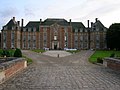 The rebuilt château, main facade; circa 2007.

.jpg)

See also[edit]
References[edit]
- ^ "Répertoire national des élus: les maires". data.gouv.fr, Plateforme ouverte des données publiques françaises (in French). 2 December 2020.
- ^ "Populations légales 2021". The National Institute of Statistics and Economic Studies. 28 December 2023.
- ^ Population en historique depuis 1968, INSEE
Wikimedia Commons has media related to Tilloloy.
| International | |
|---|---|
| National | |