
Ponthoile
Ponthoile | |
|---|---|
 The town hall and school in Ponthoile | |
 Coat of arms | |
Location of Ponthoile  | |
 Ponthoile  Ponthoile | |
| Coordinates: 50°12′59″N 1°42′48″E / 50.2164°N 1.7133°E | |
| Country | France |
| Region | Hauts-de-France |
| Department | Somme |
| Arrondissement | Abbeville |
| Canton | Abbeville-1 |
| Intercommunality | CC Ponthieu-Marquenterre |
| Government | |
| • Mayor (2020–2026) | Henri Poupart[1] |
| Area 1 | 19.41 km2 (7.49 sq mi) |
| Population (2021)[2] | 604 |
| • Density | 31/km2 (81/sq mi) |
| Time zone | UTC+01:00 (CET) |
| • Summer (DST) | UTC+02:00 (CEST) |
| INSEE/Postal code | 80633 /80860 |
| Elevation | 2–31 m (6.6–101.7 ft) (avg. 6 m or 20 ft) |
| 1 French Land Register data, which excludes lakes, ponds, glaciers > 1 km2 (0.386 sq mi or 247 acres) and river estuaries. | |
Ponthoile (French pronunciation: [pɔ̃twal]) is a commune in the Somme department of Hauts-de-France in northern France.
Geography[edit]
Ponthoile is situated on the D235 road, some 15 km northwest of Abbeville, near the bay of the Somme.
History[edit]
In 1346, during the Hundred Years War, English troops burnt and pillaged the towns of the Ponthieu on their way to the Battle of Crécy. Ponthoile was attacked on Saint-Barthélémy's day, 24 August, just two days before the battle, burning down the 12th-century church.
In the 13th century, there were 180 homes in Ponthoile, according to Dom Grenier. After the ravages of the wars against the English and Burgundians, according to English statistics, there were only 48. The population of Ponthoile subsequently increase slowly into the middle of the 19th century, before declining again, as farming became mechanisied and people left for the big cities
Demography[edit]
|
| |||||||||||||||||||||||||||||||||||||||||||||||||||||||||||||||
| Source: EHESS (1793-1999)[3] and INSEE (1968-2017)[4] | ||||||||||||||||||||||||||||||||||||||||||||||||||||||||||||||||
Main sights[edit]
- Memorial to the aviation pioneers, the brothers Caudron.
- Church of Saint Pierre. Badly damaged by two fires, it was decided, in 1836, to build a bigger, better church in brick and slate.
-
 Saint-Pierre Church.
 -
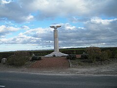 Caudron's Memorial.
 -
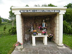 Lourdes Grotto.
 -
 Chapel Fromentin, Romaine.
 -
 Former railway station in Romaine.
 -
 Roadsign in Morlay.
 -
 Stork in Romaine.


See also[edit]
References[edit]
- ^ "Répertoire national des élus: les maires" (in French). data.gouv.fr, Plateforme ouverte des données publiques françaises. 13 September 2022.
- ^ "Populations légales 2021". The National Institute of Statistics and Economic Studies. 28 December 2023.
- ^ Des villages de Cassini aux communes d'aujourd'hui: Commune data sheet Ponthoile, EHESS (in French).
- ^ Population en historique depuis 1968, INSEE
External links[edit]
- Ponthoile municipal website (in French)
- Charter of the commune of Ponthoile (in French)
| Authority control databases: National |
|---|