
Selma, Arkansas
Selma, Arkansas | |
|---|---|
 Selma Methodist Church | |
 Selma  Selma | |
| Coordinates: 33°41′50″N 91°34′03″W / 33.69722°N 91.56750°W | |
| Country | United States |
| State | Arkansas |
| County | Drew |
| Elevation | 177 ft (54 m) |
| Time zone | UTC-6 (Central (CST)) |
| • Summer (DST) | UTC-5 (CDT) |
| Area code | 870 |
| GNIS feature ID | 57184[1] |
Selma is an unincorporated community in Drew County, Arkansas, United States.[1]
Selma is the location of a historic Rosenwald School, the Selma Rosenwald School, that was built in 1924 and is listed on the National Register of Historic Places.[2]
Education[edit]
Selma is served by the Drew Central School District.[3][4]
In 1979 the Collins and Selma school districts dissolved, with portions of the students going to the Drew Central district and portions going to the Dermott School District.[5]
References[edit]
- ^ a b "Selma". Geographic Names Information System. United States Geological Survey, United States Department of the Interior.
- ^ "National Register Information System". National Register of Historic Places. National Park Service. July 9, 2010.
- ^ "SCHOOL DISTRICT REFERENCE MAP (2010 CENSUS): Drew County, AR." U.S. Census Bureau. Retrieved on October 15, 2017. Compare district map to the highway map.
- ^ "General Highway Map Drew County, Arkansas" (PDF). Arkansas Department of Transportation. Retrieved February 25, 2021. - See Selma on the map.
- ^ Goatcher, Truett (January 1999). "School District Consolidation Will Save Millions of Dollars: Fact of Myth?" (PDF). Arkansas Association of Educational Administrators. p. 14 (PDF p. 17/27).
Municipalities and communities of Drew County, Arkansas, United States | ||
|---|---|---|
| Cities | 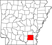 | |
| Towns | ||
| CDPs | ||
| Other unincorporated communities | ||
| Footnotes | ‡This populated place also has portions in an adjacent county or counties | |
This article about a location in Drew County, Arkansas is a stub. You can help Wikipedia by expanding it. |