
Tillar, Arkansas
Tillar, Arkansas | |
|---|---|
 Location of Tillar in Desha County and Drew County, Arkansas. | |
| Coordinates: 33°42′41″N 91°27′11″W / 33.71139°N 91.45306°W | |
| Country | United States |
| State | Arkansas |
| Counties | Drew, Desha |
| Area | |
| • Total | 0.79 sq mi (2.03 km2) |
| • Land | 0.79 sq mi (2.03 km2) |
| • Water | 0.00 sq mi (0.00 km2) |
| Elevation | 148 ft (45 m) |
| Population (2020) | |
| • Total | 172 |
| • Density | 219.11/sq mi (84.62/km2) |
| Time zone | UTC-6 (Central (CST)) |
| • Summer (DST) | UTC-5 (CDT) |
| ZIP code | 71670 |
| Area code | 870 |
| FIPS code | 05-69230 |
| GNIS feature ID | 0058746 |
Tillar is a town[2] in Desha and Drew counties in the U.S. state of Arkansas. The population was 225 at the 2010 census.[3] The area west of it was known as Tillar Station. Frank Tillar Memorial Methodist Episcopal Church, South is listed on the National Register of Historic Places.
Geography[edit]
Tillar is located at 33°42′41″N 91°27′11″W / 33.71139°N 91.45306°W (33.711383, -91.453026).[4]
According to the United States Census Bureau, the city has a total area of 0.7 square miles (1.8 km2), all land.
Demographics[edit]
| Census | Pop. | Note | %± |
|---|---|---|---|
| 1910 | 180 | — | |
| 1920 | 350 | 94.4% | |
| 1930 | 267 | −23.7% | |
| 1940 | 229 | −14.2% | |
| 1950 | 239 | 4.4% | |
| 1960 | 232 | −2.9% | |
| 1970 | 293 | 26.3% | |
| 1980 | 280 | −4.4% | |
| 1990 | 221 | −21.1% | |
| 2000 | 240 | 8.6% | |
| 2010 | 225 | −6.2% | |
| 2020 | 172 | −23.6% | |
| U.S. Decennial Census[5] | |||
As of the census[6] of 2000, there were 240 people, 99 households, and 75 families residing in the city. The population density was 325.9 inhabitants per square mile (125.8/km2). There were 110 housing units at an average density of 149.4 per square mile (57.7/km2). The racial makeup of the city was 91.67% White, 5.83% Black or African American, 0.42% Native American, 1.25% from other races, and 0.83% from two or more races. 4.58% of the population were Hispanic or Latino of any race.
There were 99 households, out of which 30.3% had children under the age of 18 living with them, 64.6% were married couples living together, 6.1% had a female householder with no husband present, and 24.2% were non-families. 21.2% of all households were made up of individuals, and 14.1% had someone living alone who was 65 years of age or older. \The average household size was 2.42 and the average family size was 2.79.
In the city the population was spread out, with 21.3% under the age of 18, 12.1% from 18 to 24, 26.3% from 25 to 44, 22.5% from 45 to 64, and 17.9% who were 65 years of age or older. The median age was 42 years. For every 100 females, there were 98.3 males. For every 100 females age 18 and over, there were 94.8 males.
The median income for a household in the city was $29,792, and the median income for a family was $34,821. Males had a median income of $23,929 versus $22,500 for females. The per capita income for the city was $13,568. About 13.4% of families and 16.5% of the population were below the poverty line, including 16.7% of those under the age of eighteen and 19.0% of those 65 or over.
Education[edit]
Its school district is the McGehee School District.[7][8]
Formerly the Desha-Drew School District operated the B. C. Prewitt Memorial Elementary and Junior High School in Tillar.[9] It also operated a school called Tillar School.[10] On July 1, 1993, the Desha-Drew district was disestablished with some territory given to the McGehee School District.[11]
There is a Christian school in Tillar, called Cornerstone Christian Academy.[12]
Notable people[edit]
- Arkansas State Representative Mark D. McElroy, who has represented District 11 since 2013, resides in Tillar.
- Charlotte Tillar Schexnayder (December 25, 1923 - December 11, 2020), a native of Tillar, was a journalist and politician who edited the McGehee Times from 1944-1946 and 1948-1954. She then owned, edited and published the Dumas Clarion from 1954-1998. She was a member of the Arkansas House of Representatives from 1985-1999.
References[edit]
- ^ "2020 U.S. Gazetteer Files". United States Census Bureau. Retrieved October 29, 2021.
- ^ Local.Arkansas.gov - Tillar, retrieved September 3, 2012
- ^ "Race, Hispanic or Latino, Age, and Housing Occupancy: 2010 Census Redistricting Data (Public Law 94-171) Summary File (QT-PL), Tillar city, Arkansas". United States Census Bureau. Retrieved August 15, 2011.
- ^ "US Gazetteer files: 2010, 2000, and 1990". United States Census Bureau. February 12, 2011. Retrieved April 23, 2011.
- ^ "Census of Population and Housing". Census.gov. Retrieved June 4, 2015.
- ^ "U.S. Census website". United States Census Bureau. Retrieved January 31, 2008.
- ^ "2020 CENSUS - SCHOOL DISTRICT REFERENCE MAP: Desha County, AR" (PDF). U.S. Census Bureau. Retrieved March 11, 2023. - 2010 map
- ^ "2020 CENSUS - SCHOOL DISTRICT REFERENCE MAP: Drew County, AR" (PDF). U.S. Census Bureau. Retrieved March 11, 2023. - 2010 map
- ^ Gertler, Diane Bochner (1969). Directory: Public Elementary and Secondary Schools in Large School Districts with Enrollment and Instructional Staff, by Race: Fall 1967, Volume 20121. U.S. National Center for Educational Statistics. p. 35.
- ^ Directory of Public Elementary and Secondary Schools in Selected Districts. U.S. Department of Health, Education, and Welfare, Office for Civil Rights. 1968. p. 35.
- ^ "ConsolidationAnnex_from_1983.xls." Arkansas Department of Education. Retrieved on October 13, 2017.
- ^ "Home". Cornerstone Christian Academy. Retrieved March 11, 2023.
909 Highway 65 N [...] Tillar AR 71670
Municipalities and communities of Desha County, Arkansas, United States | ||
|---|---|---|
| Cities |  | |
| Towns | ||
| CDP | ||
| Other unincorporated communities | ||
| Ghost town | ||
| Footnotes | ‡This populated place also has portions in an adjacent county or counties | |
Municipalities and communities of Drew County, Arkansas, United States | ||
|---|---|---|
| Cities | 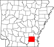 | |
| Towns | ||
| CDPs | ||
| Other unincorporated communities | ||
| Footnotes | ‡This populated place also has portions in an adjacent county or counties | |