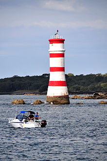
Rangitoto Lighthouse
 | |
 | |
| Location | Rangitoto Island Auckland New Zealand |
|---|---|
| Coordinates | 36°46′54.5″S 174°49′20.9″E / 36.781806°S 174.822472°E |
| Tower | |
| Constructed | 1882 |
| Construction | concrete tower |
| Height | 20 metres (66 ft) |
| Shape | cylindrical tower with balcony and lantern removed |
| Markings | white tower with four narrow horizontal bands |
| Power source | solar power |
| Operator | Ports of Auckland[1] |
| Light | |
| First lit | 1905 |
| Focal height | 21 metres (69 ft) |
| Range | 7 nmi (13 km; 8.1 mi) |
| Characteristic | Fl R 12s. |
Rangitoto Lighthouse (also called Rangitoto Beacon) is a lighthouse off the coast in McKenzie Bay, in Auckland's Hauraki Gulf.
The lighthouse was built in 1882. In 1905 a light was added for nighttime visibility.
Although not classed officially as a lighthouse by the New Zealand MSA, it does currently flash red every 12 seconds (also known as its character) and can be seen clearly from the southernmost of North Harbour's East Coast Bays.
The beacon is red and white in colour, stands at 21 metres tall, and continues to run through solar power. The height of the focal plane is 69 ft or 21 m.[2]
See also[edit]
References[edit]
- ^ Rowlett, Russ. "Lighthouses of New Zealand: North Island". The Lighthouse Directory. University of North Carolina at Chapel Hill. Retrieved 23 February 2016.
- ^ "TrekEarth: Photos". Archived from the original on 3 April 2012. Retrieved 21 June 2011.
External links[edit]
- Rangitoto Island Light in Lighthouse Digest's Lighthouse Explorer Database
- Lighthouses of New Zealand Archived 30 March 2019 at the Wayback Machine Maritime New Zealand

