
Cuvier Island Lighthouse
.jpg) | |
 | |
| Location | Cuvier Island North Island New Zealand |
|---|---|
| Coordinates | 36°26′23.2″S 175°47′10.3″E / 36.439778°S 175.786194°E |
| Tower | |
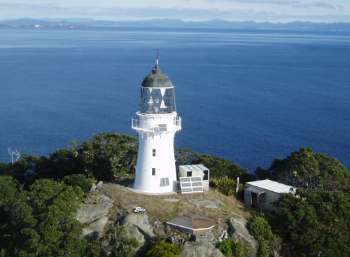
| Constructed | 1889 |
| Construction | cast iron tower |
| Automated | 1982 |
| Height | 15 metres (49 ft) |
| Shape | cylindrical tower with balcony and lantern |
| Markings | white ower, black lantern dome |
| Power source | solar power |
| Operator | Department of Conservation[1] |
| Light | |
| First lit | 1889 |
| Focal height | 119 metres (390 ft) |
| Range | 19 nautical miles (35 km; 22 mi) |
| Characteristic | Fl W 15s. |
Cuvier Island Lighthouse is a lighthouse on Cuvier Island, a small island off the east coast of the North Island of New Zealand.[2] It is owned and operated by Maritime New Zealand.
History[edit]
The light was constructed in 1889 and was the first lighthouse built in New Zealand using cast iron. The light was fully automated in 1982 and is controlled from the Maritime New Zealand headquarters in Wellington. Cuvier Island itself is a wildlife reserve which is managed by the Department of Conservation and is part of an island restoration project.
See also[edit]
References[edit]
- ^ Rowlett, Russ. "Lighthouses of New Zealand: North Island". The Lighthouse Directory. University of North Carolina at Chapel Hill. Retrieved 13 November 2015.
- ^ Cuvier Island Lighthouse Profile Archived 2015-11-17 at the Wayback Machine (from the Maritime New Zealand website)
External links[edit]
- Cuvier Island Lighthouse in Lighthouse Digest's Lighthouse Explorer Database
- Lighthouses of New Zealand Maritime New Zealand
- Picture of Cuvier Island Lighthouse The Lighthouse Directory
.jpeg)
| Authority control databases: Geographic |
|---|
This article about a New Zealand building or structure is a stub. You can help Wikipedia by expanding it. |
This lighthouse-related article is a stub. You can help Wikipedia by expanding it. |