
Moustiers-Sainte-Marie
Moustiers-Sainte-Marie
Mostiers Santa Maria (Occitan) | |
|---|---|
 The village of Moustiers-Sainte-Marie, seen from above | |
 Coat of arms | |
Location of Moustiers-Sainte-Marie  | |
 Moustiers-Sainte-Marie  Moustiers-Sainte-Marie | |
| Coordinates: 43°50′54″N 6°13′19″E / 43.8483°N 6.2219°E | |
| Country | France |
| Region | Provence-Alpes-Côte d'Azur |
| Department | Alpes-de-Haute-Provence |
| Arrondissement | Digne-les-Bains |
| Canton | Riez |
| Intercommunality | CA Provence-Alpes |
| Government | |
| • Mayor (2020–2026) | Marc Bondil[1] |
| Area 1 | 87.97 km2 (33.97 sq mi) |
| Population (2021)[2] | 706 |
| • Density | 8.0/km2 (21/sq mi) |
| Time zone | UTC+01:00 (CET) |
| • Summer (DST) | UTC+02:00 (CEST) |
| INSEE/Postal code | 04135 /04360 |
| Elevation | 474–1,729 m (1,555–5,673 ft) (avg. 631 m or 2,070 ft) |
| 1 French Land Register data, which excludes lakes, ponds, glaciers > 1 km2 (0.386 sq mi or 247 acres) and river estuaries. | |
Moustiers-Sainte-Marie (French pronunciation: [mustje sɛ̃t maʁi]; Occitan: Mostiers Santa Maria), or simply Moustiers, is a commune in the Alpes-de-Haute-Provence department in the Provence-Alpes-Côte d'Azur region of Southeastern France. It is considered one of the "most beautiful villages of France".
Geography[edit]
It lies at the western entrance to the Verdon Gorge (Gorges du Verdon). The village has been a centre of the pottery trade, especially faïence, for centuries. A spring flows out of the cliff and creates a waterfall in town, providing water power.
The village was built on platform terraces a hundred or so metres up the side of a limestone cliff. At twilight, when the sun on a clear day strikes the south-facing cliff, a diffuse pink light glows across the village.
The Star[edit]
Above the town, a gold-painted star hangs on a 225m-long chain suspended between two cliffs. Its origin, according to a legend popularised by Provençal poet Frédéric Mistral, lies in the 10th century; the original star and chain have been replaced several times since then. The current star is about 50 years old. Ten years ago it fell after the chain snapped, and was rehung using a helicopter.[3][4][5]
Legend[edit]
According to the legend, during the Crusades the knight Bozon de Blacas was held prisoner by the Saracens; he vowed to hang a star over his village if he was able to return. No one knows how the star was originally hung there.[6]
Population[edit]
| Year | Pop. | ±% p.a. |
|---|---|---|
| 1968 | 535 | — |
| 1975 | 602 | +1.70% |
| 1982 | 575 | −0.65% |
| 1990 | 580 | +0.11% |
| 1999 | 625 | +0.83% |
| 2009 | 718 | +1.40% |
| 2014 | 686 | −0.91% |
| 2020 | 718 | +0.76% |
| Source: INSEE[7] | ||
International relations[edit]
Moustiers-Sainte-Marie is twinned with Montelupo Fiorentino in Italy.
See also[edit]
References[edit]
- ^ "Répertoire national des élus: les maires" (in French). data.gouv.fr, Plateforme ouverte des données publiques françaises. 13 September 2022.
- ^ "Populations légales 2021". The National Institute of Statistics and Economic Studies. 28 December 2023.
- ^ "Histoire". Office de Tourisme de Moustiers Sainte Marie. Archived from the original on 24 February 2007. Retrieved 10 October 2010.
- ^ "The village of Moustiers Sainte Marie". La Bastide de Moustiers. Archived from the original on 29 April 2006. Retrieved 18 June 2006.
- ^ Collins, Sarah (3 March 2002). "A Wild Road Follows A Wild River". New York Times, Travel Section. Retrieved 30 August 2006.
- ^ "Tourist information in English". Archived from the original on 16 January 2011. Retrieved 10 October 2010.
- ^ Population en historique depuis 1968, INSEE
-
 A view from outside the village
 -
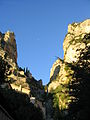 The peaks above the village, with the famous star suspended between
 -
 Engraving from an eighteenth-century painting of the village
 -
 Close-up of the golden star hanging over Moustiers-Sainte-Marie
 -


External links[edit]
| International | |
|---|---|
| National | |
| Other | |
This Alpes-de-Haute-Provence geographical article is a stub. You can help Wikipedia by expanding it. |