
Ars-en-Ré
Ars-en-Ré | |
|---|---|
 The anchorage in Ars-en-Ré | |
.svg) Coat of arms | |
Location of Ars-en-Ré  | |
 Ars-en-Ré  Ars-en-Ré | |
| Coordinates: 46°12′29″N 1°30′57″W / 46.2081°N 1.5158°W | |
| Country | France |
| Region | Nouvelle-Aquitaine |
| Department | Charente-Maritime |
| Arrondissement | La Rochelle |
| Canton | Île de Ré |
| Intercommunality | CC Île Ré |
| Government | |
| • Mayor (2020–2026) | Danièle Pétiniaud-Gros[1] |
| Area 1 | 10.95 km2 (4.23 sq mi) |
| Population (2021)[2] | 1,297 |
| • Density | 120/km2 (310/sq mi) |
| Demonym | Casserons |
| Time zone | UTC+01:00 (CET) |
| • Summer (DST) | UTC+02:00 (CEST) |
| INSEE/Postal code | 17019 /17590 |
| Elevation | 0–15 m (0–49 ft) (avg. 6 m or 20 ft) |
| 1 French Land Register data, which excludes lakes, ponds, glaciers > 1 km2 (0.386 sq mi or 247 acres) and river estuaries. | |
Ars-en-Ré (French pronunciation: [aʁs ɑ̃ ʁe]) is a commune on the Île de Ré in the western French department of Charente-Maritime, in Nouvelle-Aquitaine. Formerly called just Ars, the commune changed to its current name on 8 March 1962.[3]
Geography[edit]

Ars-en-Ré is one of 10 communes located on the Île de Ré off the coast of La Rochelle and is in the north-western part of the island some 8 km west of Saint-Martin-de-Ré. Access to the commune is by the D735 road which crosses to the island from the end of National Highway N237 at La Rochelle. The D735 passes along the north coast of the island through Saint-Martin-de-Ré and continues north-west to the commune passing through the town and continuing north-west to the Baleines Lighthouse. Apart from the town there is the village of La Grange nearby on the coast and Le Martray to the east along the coast. The town occupies the centre of the commune and there are forests on the western side with the rest of the commune farmland including extensive salt farms.[4]

Its harbour is the largest on the Île de Ré and is located at the bottom of the Fier d'Ars (a body of water penetrating the land from the north-east and bordered by marshes), which is reached by a channel through the salt farms. A lock closes the tidal basin which has 250 berths. A new basin with 130 berths is to be created in future[when?] at the channel entrance. There are 150 moorings on buoys in the outer harbour and the channel has a capacity of 550 berths, mainly dedicated to pleasure craft. A beach on the south coast of the island, bordered by a dyke to protect the land, extends to the Baleines Lighthouse at the western tip of the island.
Neighbouring communes and villages[edit]
Places adjacent to Ars-en-Ré | |
|---|---|
History[edit]
The Prince of Soubise was defeated here in 1624.[5]
The port was important during the "salt era" until the beginning of the 20th century. The gabelle or salt tax was significant in the area.
Heraldry[edit]
|
Blazon: Or semé-de-lis azure, a galley gules.
|
Administration[edit]

List of Successive Mayors[6]
| From | To | Name | Party |
|---|---|---|---|
| 1959 | 1966 | Jacques Moinet | |
| 1983 | 1995 | Emile Gaudin | UDF |
| 1995 | 2020 | Jean-Louis Olivier | UMP |
| 2020 | 2026 | Danièle Pétiniaud Gros |
Demography[edit]
The inhabitants of the commune are known as Arsais or Arsaises in French,[7] but they are nicknamed the Casserons: the casseron is a baby cuttlefish, a saltwater fish commonly found on the island.
|
| ||||||||||||||||||||||||||||||||||||||||||||||||||||||||||||||||||||||||||||||||||||||||||||||||||||||||||||||||||
| |||||||||||||||||||||||||||||||||||||||||||||||||||||||||||||||||||||||||||||||||||||||||||||||||||||||||||||||||||
| Source: EHESS[8] and INSEE[9] | |||||||||||||||||||||||||||||||||||||||||||||||||||||||||||||||||||||||||||||||||||||||||||||||||||||||||||||||||||
Distribution of Age Groups[edit]
The population of the town is relatively old. The ratio of persons above the age of 60 years (40.2%) is higher than the national average (21.6%) and the departmental average (28.1%). As with national and departmental allocations, the male population of the town is less than the female population (45.9% against 48.4% nationally and 48.2% at the departmental level).
Percentage Distribution of Age Groups in Ars-en-Ré and Charente-Maritime Department in 2017
| Ars-en-Ré | Charente-Maritime | |||
|---|---|---|---|---|
| Age Range | Men | Women | Men | Women |
| 0 to 14 Years | 13.9 | 9.6 | 16.3 | 14.3 |
| 15 to 29 Years | 11.7 | 8.8 | 15.4 | 13.1 |
| 30 to 44 Years | 16.4 | 15.6 | 16.7 | 16.1 |
| 45 to 59 Years | 19.1 | 17.4 | 20.2 | 19.9 |
| 60 to 74 Years | 23.5 | 24.1 | 21.1 | 22.0 |
| 75 to 89 Years | 13.0 | 18.2 | 9.4 | 12.3 |
| 90 Years+ | 2.5 | 6.4 | 1.0 | 2.4 |
Sites and Monuments[edit]
The village is a member of Les Plus Beaux Villages de France (the most beautiful villages in France).[11]
Since 2011 the commune has belonged to the network "Villages of stone and water", a label initiated by the General Council to promote exceptional sites with the distinction of being located near a body of water (sea, river, pond ...).[12]
Civil Heritage[edit]
Ars-en-Ré has a number of buildings that have been registered as historical monuments by the Ministry of Culture. These are:
- Windmills (17th-18th century)
 [13]
[13] - Houses (16th-20th century)[14]
- Guardhouse at Place Carnot (18th century)[15]
- War Memorial at Place Carnot (1925)[16]
- Jules Perrier Museum at Place de la Chapelle (19th century)[17]
- Salt Refinery at Rue de Mouillebarbe (19th century)[18]
- Two Salt Works on Rue Mouillebarbe (19th century)[19]
- Tower at Batterie-Karola (1942-1944)[20]
- Kora-Karola Artillery Battery which was part of the German Atlantic Wall (military area).[21][22]
- Fort of Le Martray (1674)[21][23]
There are over 200 items in Ars-en-Ré that are registered as historical objects, several of which are in private collections.[24]
- Other sites of interest
- The Port with its new tidal basin at the entrance of the access channel.
- Le Martray, the narrowest point of the island.
- The Fiers d'Ars
- Salt farms
- The old station of the Petit train de l'Île de Ré (1898) at the port.
- The surfing spot at Grignon Point.
Religious Heritage[edit]
Many religious buildings and monuments are registered as historical monuments at the Ministry of Culture:
- The Priory of Saint-Étienne in the Place Carnot (11th-17th centuries)[25] The Priory contains a very large number of items that are registered as historical objects.[25]
- The Convent of the Sisters of Wisdom at Rue du Havre (1862)[26]
- A Monumental Cross at the Port (1899)[27]
- A Monumental Cross on the Route de Saint-Clément (1836)[28]
- The Pinaud Cross on the Route de Saint-Clément (destroyed)(17th century)[29]
- A Monumental Cross on N735 (1890)[30]
- The Church of Saint-Étienne (12th century).[31] Its bell tower, painted in black and white, serves as a Daymark for sailors.
- The Convent of the Sisters of Charity (18th century)[32]
- The Protestant Church (destroyed) (1603)[33]
Ars-en-Ré Picture Gallery[edit]
- Ars-en-Ré
-
 16th century House in the town
 -
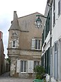
 The Seneschal House
 -
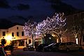 Christmas lights
 -
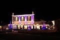 Christmas lights
 -
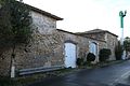 The old salt refinery
 -
 Le Martray Fort
 -
 The channel giving access to the Fier d'Ars
 -
 The old railway station
 -
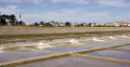 Salt ponds


.JPG)
.JPG)


.JPG)


- The Church
-
 Church entrance
 -
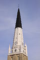 The Church steeple
 -
 The Nave
 -
 The Altar
 -
 Pieta in the church
 -
 The pulpit
 -
 Stained Glass window

.JPG)


- Birds
-
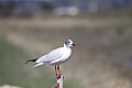 Seagull
 -
 White stilt
 -
 Wood pigeon
 -
 Brown seagulls
 -
 Swan
Swan -
 Heron
Heron -
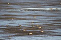 Sandpipers
 -
 Crested Peewit
.JPG)
.JPG)
.JPG)
.JPG)
.JPG)
.JPG)
.JPG)

- Fishing and Boats
-
 The harbour
 -
 A pleasure fishing boat
 -
 Fishing boat
 -
 Lobster pots
 -
 Penants for fishing buoys
 -
 A leisure barge


.JPG)
.JPG)
.JPG)

Notable people linked to the commune[edit]
- Mathurin Renaud (14 October 1641 – 1676), born in Ars-en-Ré (parish of Saint-Étienne), an important historical figure: a pioneer of New France and one of the first inhabitants of Charlesbourg.
- William Barbotin (1861-1931), painter and engraver.
- Marie-Thérèse Dethan-Roullet (1870-1945), painter, was born here.
- Lionel Jospin, former Prime Minister of France, had a house here where he stayed regularly.
- Claude Barma, former Italian Film director, father of Catherine Barma, was buried here.
- In the Narthex of the church there is a representation of John Vianney (1786-1859), the famous "Curé of Ars" although he was a priest in the commune of Ars-sur-Formans in Ain.
See also[edit]
References[edit]
- ^ "Répertoire national des élus: les maires" (in French). data.gouv.fr, Plateforme ouverte des données publiques françaises. 13 September 2022.
- ^ "Populations légales 2021". The National Institute of Statistics and Economic Studies. 28 December 2023.
- ^ Commune d'Ars-en-Ré (17019), INSEE
- ^ a b Google Maps
- ^ Dezobry and Bachelet, Dictionary of Biography, t.1, Ch. Delagrave, 1876, p. 149 (in French)
- ^ List of Mayors of France (in French)
- ^ Le nom des habitants du 17 - Charente-Maritime, habitants.fr
- ^ Des villages de Cassini aux communes d'aujourd'hui: Commune data sheet Ars-en-Ré, EHESS (in French).
- ^ a b Évolution et structure de la population en 2017: Commune d'Ars-en-Ré (17019)
- ^ Évolution et structure de la population en 2017: Département de la Charente-Maritime (17)
- ^ Ars-en-Ré on the most beautiful villages in France website
- ^ 13 villages unite for better or for worse, article by Thomas Brosset published in Sud Ouest, 10 February 2011 (in French)
- ^ Ministry of Culture, Mérimée IA00042975 La Boire (1) IA00042976 La Boire (2) IA00042977 La Boire (3) IA00042982 Moulin de la Fontaine IA00042978 La Grelière (in French)

- ^ Ministry of Culture, Mérimée IA00042964 Rue d'Angleterre (1) IA00042962 Rue d'Angleterre (2) IA00042961 Rue d'Angleterre (3) IA00042967 Rue des Bardons IA00042970 Rue de la Boire IA00042950 Place Carnot IA00042963 Rue du Cinq Un IA00043324 Rue du Corneau IA00043329 Rue du Havre (1) IA00042952 Rue du Havre (2) IA00042951 Rue du Havre (3) IA00042955 Winemakers House at Ruelle des Marais IA00042960 Winemakers House at Rue Nationale IA00042969 Rue des Ormeaux (1) IA00042968 Rue des Ormeaux (2) IA00042971 Rue des Ormeaux (3) IA00042966 Rue du Palais (1) IA00042965 Rue du Palais (2) IA00042958 Rue Ravalante IA00042953 Rue Simon IA00042956 Impasse Thiers IA00042948 Le Graffaud House at Rue Thiers IA00042957 Rue Thiers (1) IA00042954 Rue Thiers (2) IA00042959 Rue Thiers (3) IA00042949 Seneschal House at Rue des Tourelles PA00104600 Manor at Rue des Tourelles IA00042981 Le Martray IA00042979 Le Boutillon IA00042940 20 Houses (in French)
- ^ Ministry of Culture, Mérimée IA00043328 Guardhouse at Place Carnot (in French)
- ^ Ministry of Culture, Mérimée IA00042973 War Memorial at Place Carnot (in French)
- ^ Ministry of Culture, Mérimée IA00042941 Jules Perrier Museum at Place de la Chapelle (in French)
- ^ Ministry of Culture, Mérimée PA00105304 Salt Refinery at Rue de Mouillebarbe (in French)
- ^ Ministry of Culture, Mérimée IA00043327 Salt Works (1) IA00042972 Salt Works (2) (in French)
- ^ Ministry of Culture, Mérimée IA00042974 Tower at Batterie-Karola (in French)
- ^ a b Coastal Fortifications - Charente Maritime, R. Desquesne, R. Faille, N. Faucherre, and P. Prost, Éditions patrimoine et médias, ISBN 2-910137-03-1 (in French)
- ^ Ministry of Culture, Mérimée PA17000044 Kora-Karola Artillery Battery (in French)
- ^ Ministry of Culture, Mérimée IA00042980 Fort of Le Martray (in French)
- ^ Base Palissy: Search for heritage in the commune, Ministère français de la Culture. (in French)
- ^ a b Ministry of Culture, Mérimée IA00042943 Priory of Saint-Étienne at Place Carnot (in French)
- ^ Ministry of Culture, Mérimée IA00043325 Convent of the Sisters of Wisdom at Rue du Havre (in French)
- ^ Ministry of Culture, Mérimée IA00042947 Monumental Cross at the Port (in French)
- ^ Ministry of Culture, Mérimée IA00042945 Monumental Cross on the Route de Saint-Clément (in French)
- ^ Ministry of Culture, Mérimée IA00042944 Pinaud Cross on the Route de Saint-Clément (in French)
- ^ Ministry of Culture, Mérimée IA00042946 Monumental Cross on N735 (in French)
- ^ Ministry of Culture, Mérimée PA00104599 Church of Saint-Étienne (in French)
- ^ Ministry of Culture, Mérimée IA00043326 Convent of the Sisters of Charity (in French)
- ^ Ministry of Culture, Mérimée IA00042942 Protestant Church (in French)
External links[edit]
- Ars-en-Ré official website (in French)
- Île de Ré on the official site of the department of Charente-Maritime (in French)
- Ars-en-Ré on Géoportail, National Geographic Institute (IGN) website (in French)
- Ars on the 1750 Cassini Map
| International | |
|---|---|
| National | |