
Epleys, Kentucky
Epleys, Kentucky | |
|---|---|
 Epleys  Epleys | |
| Coordinates: 36°55′37″N 86°56′19″W / 36.92694°N 86.93861°W | |
| Country | United States |
| State | Kentucky |
| County | Logan |
| Elevation | 676 ft (206 m) |
| Time zone | UTC-6 (Central (CST)) |
| • Summer (DST) | UTC-5 (CDT) |
| Area code(s) | 270 & 364 |
| GNIS feature ID | 491798[1] |
Epleys (also known as Epley Station, Epley's Station) is an unincorporated community in Logan County, Kentucky, United States.[1] The community is located on U.S. Route 431 and a CSX Transportation (formerly Louisville and Nashville Railroad) line, 4 miles (6.4 km) northwest of Russellville.[2]
History[edit]
Epleys was established circa 1872 as a future station along the railroad, which was expected to be built through the area. Fritz Epley was the first settler and gave the community its name. The community had post offices under two different names: one as Epley from 1887 to 1888, and one as Epley Station from 1891 to 1921.[3]
Notable residents[edit]
- Velma Williams Smith, country musician, was born in Epleys.[4]
Notes[edit]
- ^ a b "Epleys, Kentucky". Geographic Names Information System. United States Geological Survey, United States Department of the Interior.
- ^ State Primary Road System: Logan County (PDF) (Map). Kentucky Transportation Cabinet. February 2015. Retrieved January 22, 2016.
- ^ Rennick, Robert M. (August 28, 2013). Kentucky Place Names. University Press of Kentucky. ISBN 9780813144016.
- ^ Epley native Velma Williams Smith to enter Hall tonight
Municipalities and communities of Logan County, Kentucky, United States | ||
|---|---|---|
| Cities | 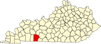 | |
| CDP | ||
| Other unincorporated communities | ||
| Footnotes | ‡This populated place also has portions in an adjacent county or counties | |
This Logan County, Kentucky state location article is a stub. You can help Wikipedia by expanding it. |