
Bundesautobahn 24
You can help expand this article with text translated from the corresponding article in German. (April 2023) Click [show] for important translation instructions.
|
 | ||||
|---|---|---|---|---|
| Bundesautobahn 24 | ||||
 | ||||
| Route information | ||||
| Length | 237 km (147 mi) | |||
| Major junctions | ||||
| West end | Hamburg | |||
| East end | ||||
| Location | ||||
| Country | Germany | |||
| States | Hamburg, Schleswig-Holstein, Mecklenburg-Vorpommern, Brandenburg | |||
| Highway system | ||||
| ||||
| ||||
Bundesautobahn 24 (translates from German as Federal Motorway 24, short form Autobahn 24, abbreviated as BAB 24 or A 24) is an autobahn in northern Germany that connects the large metropolitan regions of Hamburg and Berlin. It was one of the three transit access roads to West Berlin during the Cold War.
On that road, there is a 150 km (93 mi) long section that has no speed limit at all (only a recommended speed of 130 km/h), which means that about 65% of that Autobahn can be driven at very high speed.
History[edit]
Planning for the autobahn began as far back as the 1930s; before World War II numerous bridges and sections of roadside shoulder were built between Hamburg and Berlin. The German divide, however, put a hold on further work and it was not until 1978 that construction was resumed, carried out by a GDR work force and paid for by West Germany. In 1982 the A 24 could finally be opened. Most pre-war bridges could not be used, however, and were replaced by new structures.
Exit list[edit]
| State | District | Location | km | mi | Exit | Name | Destinations | Notes |
|---|---|---|---|---|---|---|---|---|
| Hamburg | Hamburg-Mitte | Horn, Hamburg | 0.0 | 0.0 | 1 | Hamburg-Horn | Hamburg-Horn, Hamburg Airport | Western endpoint of motorway
Roundabout with local roads |
| Billstedt | 3.5 | 2.2 | 2 | Hamburg-Jenfeld | Hamburg-Jenfeld | |||
| Schleswig-Holstein | Stormarn | Barsbüttel | 6.6 | 4.1 | 3 | Hamburg-Ost interchange | no ramps between Lübeck and Berlin | |
| 10.8 | 6.7 | 4 | Reinbek | Reinbek, Glinde, Barsbüttel | ||||
| Reinbek | 15.8 | 9.8 | Rest area | Hahnenkoppel | Hahnenkoppel rest area | |||
| Witzhave | 17.4 | 10.8 | 5 | Witzhave | Witzhave, Trittau, Grande | Trittau and Grande are only signed eastbound | ||
| Herzogtum Lauenburg | Kasseburg | 23.0 | 14.3 | 6 | Schwarzenbek/Grande | Lauenburg is only signed eastbound
Kiel and Lübeck are only signed westbound | ||
| 23.0 | 14.3 | 6 | Schwarzenbek/Grande interchange | interchange proposed | ||||
| Elmenhorst | 33.1 | 20.6 | 7 | Talkau | Schwarzenbek is only signed westbound | |||
| Tramm | 37.1 | 23.1 | Rest area | Tramm | Tramm rest area | westbound only | ||
| Rosenburg | 37.9 | 23.5 | Rest area | Roseburg | Roseburg rest area | eastbound only | ||
| Hornbek | 39.0 | 24.2 | 8 | Hornbek | Hornbek, Büchen, Lauenburg | |||
| Besenthal | 44.8 | 27.8 | 8b | Gudow | Gudow, Büchen | |||
| Gudow | 50.4 | 31.3 | Rest area | Gudow | Gudow rest area | rest area is equipped with a gas station and a restaurant
Rest area is a former border checkpoint between west and east germany | ||
| Mecklenburg-Vorpommern | Ludwigslust-Parchim | Lüttow-Valluhn | 52.7 | 32.7 | 9a | Gallin | Gallin | incomplete junction: only ramps from and towards Hamburg |
| 53.6 | 33.3 | Rest area | Schaalsee | Schaalsee | rest area is equipped with a gas station and a restaurant
eastbound only | |||
| 56.5 | 35.1 | 9b | Zarrentin | |||||
| Wittenburg | 69.7 | 43.3 | 10 | Wittenburg | Wittenburg, Hagenow-Kietz | |||
| 71.9 | 44.7 | Rest area | Wittenburger Land | Wittenburger Land rest area | ||||
| Bandenitz | 81.6 | 50.7 | 11 | Hagenow | ||||
| Hoort | 87.0 | 54.1 | Rest area | Schremheide | Schremheide rest area | |||
| Wöbbelin | 98.3 | 61.1 | 12 | Wöbbelin | Wöbbelin, Schwerin, Ludwigslust-Nord | |||
| 100.3 | 62.3 | 13 | Schwerin interchange | Rostock is only signed eastbound | ||||
| Neustadt-Glewe | 108.6 | 67.5 | 14 | Neustadt-Glewe | Neustadt-Glewe, Ludwigslust | |||
| Brenz | 110.9 | 68.9 | Rest area | Blievenstorf | Blievenstorf rest area | |||
| Stolpe | 116.1 | 72.1 | Rest area | Stolpe | Stolpe rest area | |||
| Karrenzin | 121.5 | 75.5 | 15 | Parchim | Parchim, Ziegendorf | |||
| Brandenburg | Prignitz | Putlitz | 135.2 | 84.0 | 16 | Suckow | Parchim Süd and Parchim int. Airport are only signed westbound | |
| 141.4 | 87.9 | Parking area | — | Parking area | ||||
| 142.6 | 88.6 | 17 | Putlitz | Putlitz | ||||
| Triglitz | 146.7 | 91.2 | Rest area | Dorngrund | Dorngrund rest area | |||
| Gerdshagen | 152.2 | 94.6 | 18 | Meyenburg | Pritzwalk-Nord is only signed eastbound
Plau am See is only signed westbound | |||
| Pritzwalk | 158.3 | 98.4 | Parking area | Kiebitzberg (eastbound) Blesenberg (westbound) | Kiebitzberg parking area (eastbound) Blesenberg parking area (westbound) | |||
| Ostprignitz-Ruppin | Heiligengrabe | 168.7 | 104.8 | 19 | Pritzwalk | Wittstock is only signed eastbound | ||
| Wittstock/Dosse | 172.8 | 107.4 | 20 | Wittstock/Dosse interchange | main carriageway runs between Berlin and Rostock | |||
| Heiligengrabe | 175.1 | 108.8 | Rest area | Prignitz | Prignitz rest area | rest area equipped with a restaurant | ||
| Wittstock/Dosse | 181.6 | 112.8 | 21 | Herzsprung | Herzsprung, Kyritz | Kyritz is only signed eastbound | ||
| 185.1 | 115.0 | Parking area | — | Parking area | ||||
| Temnitzquell | 189.7 | 117.9 | Rest area | Rossower Heide | Rossower Heide rest area | westbound only | ||
| 192.1 | 119.4 | Rest area | — | Rest area | eastbound only | |||
| Walsleben | 197.8 | 122.9 | Rest area | Walsleben | Walsleben rest area | rest area equipped with a gas station and a restaurant | ||
| Dabergotz | 205.1 | 127.4 | 22 | Neuruppin | Bückwitz is only signed eastbound
Kyritz is only signed westbound | |||
| Neuruppin | 208.7 | 129.7 | Rest area | Ruppiner See | Ruppiner See rest area | |||
| Fehrbellin | 211.9 | 131.7 | 23 | Neuruppin-Süd | Neuruppin-Süd | |||
| 217.2 | 135.0 | 24 | Fehrbellin | Fehrbellin | ||||
| 224.5 | 139.5 | Rest area | Linumer Bruch | Linumer Bruch rest area | rest area equipped with a gas station and a restaurant | |||
| Oberhavel | Kremmen | 234.0 | 145.4 | 25 | Kremmen | |||
| 236.5 | 147.0 | 26 | Havelland interchange | Eastern endpoint od motorway | ||||
1.000 mi = 1.609 km; 1.000 km = 0.621 mi
| ||||||||
Pictures[edit]
-
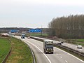 Autobahn 24 near junction Schwerin
 -
 unused bridge near Hagenow on the former planned route of the 1930s
 -
 Truck destroyed the central barrier on the A24 (Feb. 2009)

.jpg)

External links[edit]
- Bundesautobahn 24 – detailed route plan (in German)

| International | |
|---|---|
| National | |
| Geographic | |
This German road or road transport-related article is a stub. You can help Wikipedia by expanding it. |