
Uttum
Uttum | |
|---|---|
 | |
 Coat of arms | |
Location of Uttum  | |
 Uttum  Uttum | |
| Coordinates: 53°27′09″N 7°09′18″E / 53.45240°N 7.15508°E | |
| Country | Germany |
| State | Lower Saxony |
| District | Aurich |
| Municipality | Krummhörn |
| Area | |
| • Metro | 11.74 km2 (4.53 sq mi) |
| Elevation | 0 m (0 ft) |
| Population | |
| • Metro | 494 |
| Time zone | UTC+01:00 (CET) |
| • Summer (DST) | UTC+02:00 (CEST) |
| Postal codes | 26736 |
| Dialling codes | 04923 |
Uttum is a village in the region of East Frisia, in Lower Saxony, Germany. It is part of the municipality of Krummhörn. The village is located to the northeast of Pewsum.
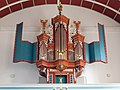
Uttum used to be a seat of East Frisian chieftains, seated at Uttum Castle. The meaning of the village's name is presumably home of Otte or Utte.[1] The Evangelical Reformed Church of Uttum dates from the 13th century and is home to an organ that was made in around 1655.[2][3]
Gallery[edit]
-
 Rentmaster's house
 -
 Windmill
 -


.jpg)
References[edit]
- ^ "Uttum". Greetsiel-Krummhoern.de (in German). Retrieved 19 March 2024.
- ^ "Evangelisch - reformierte Kirchengemeinde Uttum" [Evangelical - Reformed parish of Uttum]. Reformiert.de (in German). Retrieved 19 March 2024.
- ^ "Uttum, Evangelische Kirche" [Uttum, Evangelical Church]. De Orgelsite (in Dutch). Retrieved 19 March 2024.
External links[edit]
![]() Media related to Uttum at Wikimedia Commons
Media related to Uttum at Wikimedia Commons
Villages in the municipality of Krummhörn | ||
|---|---|---|
This German location article is a stub. You can help Wikipedia by expanding it. |