
User talk:Trasamundo/Archive 1
| This page is an archive of past discussions. Do not edit the contents of this page. If you wish to start a new discussion or revive an old one, please do so on the current talk page. |
Small request
Hello, Trasamundo, and a belated welcome to Wikipedia! I was just wondering if you could edit your user page to make one small adjustment, which would be to replace {{editor toc}} with {{editor toc|category=}}? This would have no visible effect except to remove your user page from Category:Editor handbook, which that template normally adds pages to. (If you're interested in how that works, see Template talk:Tlrow#Category magic.) Thanks! Lenoxus " * " 22:15, 30 June 2008 (UTC)

¡Hola, Trasamundo!
De cierto le digo que tomé notas de lo que escribió en Commons.
¿Y qué nos dice de la decisión aquí de mostrar los dos mapas? SamEV (talk) 23:52, 16 December 2008 (UTC)
Spanish Empire
Gracias por su respuesta, Trasamundo.
Sí, es cierto. Había un casi-compromiso para mostrar dos mapas. Pero EHT, Cosialscastells, y Jan nunca lo aceptaron, o no por completo. Al final no nos pusimos de acuerdo, todo se tornó confuso (al punto que Pat hasta abogó por el mapa de ahora en cierto momento; no sé con que fin, pero probablemente uno temporario), el semi-compromiso de derrumbó, y bueno, aquí estamos. Yo terminé uniéndome a EHT, Cosialscastells, y Jan en favor de un sólo mapa.
..."este mapa animado no se tiene por qué ser realizado por The Ogre"...
De acuerdo. Tal vez EHT podría hacer ese mapa.
Ahora bien. A mi me pareció una buena idea la del mapa animado desde que The Ogre me informó del plan en Octubre. Sin embargo, siempre he tenido una duda: es probable que el mapa animado no sea compatible con algunos espejos (mirrors) de Wikipedia. Y además está el problema de que cuando alguien imprima el artículo, ¿cual mapa, de los varios en el gif, se va imprimir? ¿O se imprimirán todos? Hay escuelas que usan mucho contenido de Wikipedia... Tal vez estos no son problemas grandes, pero son problemas, creo yo.
Dígame, Trasamundo: ¿cual considera usted como la mejor opción de todas? Olvidando, por el momento, lo que haya acordado con The Ogre, e incluso la opinión de cualquiera que no quiera que se muestre al imperio portugués. ¿Cree usted que un mapa animado de veras es lo mejor, tomando en cuenta los problemitas que acabo de mencionar? Si fuera usted quien manda, si fuera suya la decisión única (inapelable), ¿qué mapa mostraría?
Concerniente a este mapa (versión actualizada, usada en el artículo), sí: pretende ser anacrónico de todo el periodo, toda la historia/duración del imperio español. Y muestra al Imperio Portugués como era en 1580-1640, porque ese fue el periodo de la 'Unión'. O sea, el mapa es anacrónico para el Imperio Español propio. Pero ese anacronismo no se extiende al Imperio Portugués también; sólo se muestra al portugué durante la fase de la Unión, mostrando correctamente, de esa forma, las áreas portuguesas que España sí controló: Cualquier otras áreas que Portugal sólo haya controlado antes o después del 1580 a 1640 no fueron parte del Imperio Español, excepto ciertas áreas que cambiaron de dueño, como la hoy Guinea Ecuatorial, por ejemplo, que era portuguesa, hasta el 1778, cuando la adquirió España.
Ah, pero ahí veo un problema: Terminó siendo española, por lo que se le colorea rojo; pero durante la Unión ¡era portuguesa! Creo que eso se arregla añadiendo otro color — para áreas que luego cambiaron de dueño.
Pero no entiendo porqué usted se opone a los mapas anacrónicos. Sí, mezclan épocas, pero esa es la idea. La simple idea es nada más mostrar todas las áreas que en algún tiempo fueron parte del imperio español: y el hecho de que no corresponden a ningún periodo o año en particular es expresado en el texto que acompaña al mapa. No se está confundiendo al lector; todo está claro, explícito.
Hasta luego. SamEV (talk) 03:11, 19 December 2008 (UTC)
En cuanto al uso de un mapa anacrónico y estático: A lo que te opones no es a que en el aparecen todas las posesiones de España en una misma vista; sinó al hecho de que no están segmentadas, en diferentes colores, para que el lector pueda saber cuales pertenecieron a cual época, ¿verdad? Si es así, yo acepto tu sugerencia de que se segmenten.
Y sí, debemos probar con otros colores que el púrpura para las colonias portuguesas.
"El uso de un mapa anacrónico no excluye el gif animado, y en este mapa animado los territorios tendrían el mismo color puesto que no hay mezcla de época."
Sí lo excluye, Trasamundo. El gif no es más que una sucesión de mapas estáticos, mostrados a unos segundos el uno del otro. Y si ninguno de esos mapas incluye todas las áreas que fueron parte del imperio español a lo largo de toda su historia, entonces no hay mapa anacrónico (total) en el gif. Pero entiendo lo que dices.
"Por último, añadir, que la elaboración y detalle de un mapa, ¿no tendría que ser discutida en la página de commons del mapa a editar, y no repartir dichos planteamientos por las páginas de usuario?"
Ahora que lo dices, creo que sí. :) Nos veremos en Commons, entonces. (Sólo leí la discusión hasta Octubre.) SamEV (talk) 15:11, 20 December 2008 (UTC)
Trasamundo, si te referías a esta página de Commons, ya veo que no hay nuevos comentarios en los últimos dos meses.
Creo que nuestra práctica debe ser esta: discutir todos los cambios mayores en Talk:Spanish Empire, mientras que los cambios menores los podemos discutir en las páginas de usuario. A mí me gusta usar las de usuario porque es más fácil enterarse de los mensajes recibidos, debido al sistema que informa automáticamente. SamEV (talk) 17:31, 21 December 2008 (UTC)
Spain, Castile, Portugal
I agree with what I think you are saying - please correct me if I am wrong that you are stating:
- Spain was a composition of several kingdoms.
- Between 1580 and 1640, Portugal was one of these kingdoms.
- The relationship between Portugal and Castile was like that of Aragon and Castile.
I fully agree with all of the above. I also understand the following from my reading of sources (again, please let me know which, if any, points you disagree with):
- New Spain, New Granada, Peru, Philippines etc belonged to the Kingdom of Castile.
- Brazil, Estado da India etc belonged to the Kingdom of Portugal.
- Castile and Portugal, and their empires, were always legally separate during the union.
- Philip promised at the Cortes in 1580 to keep them separate in actuality too. (As this source says [1] "for the most part, he kept his promises")
Therefore, I suggest, the situation, and the whole dispute, hinges on what we, and historians, mean by "Spain".
- If we take (as some historians do) "Spain (1580-1640)" to mean Castile + Aragon + Navarre + Portugal, then we must say that the "Spanish" Empire included the Portuguese colonies.
- If we take (as other historians do) "Spain (1580-1640)" to mean Castile + Aragon + Navarre, but NOT Portugal, then the "Spanish" Empire did not include the Portuguese colonies.
And this is how we have the dispute that we do: it's really just a matter of the semantics of "Spain". What do you think? The Red Hat of Pat Ferrick t 04:51, 31 December 2008 (UTC)
- Happy new year to you too! That's good, I'm glad we are in agreement. The Red Hat of Pat Ferrick t 15:38, 1 January 2009 (UTC)
- Creo que el "Profesor de Historia de Europa" no le gusta su mapa [2] The Red Hat of Pat Ferrick t 02:24, 4 January 2009 (UTC)
- Ferrick what you are showing basically is contradictory, i just said i don't like my own maps better, but i find Trasamundo's map to be innacurate, also i dont believe the reader will be able to read the captions [[3]] in the sumary part--EuroHistoryTeacher (talk) 21:51, 4 January 2009 (UTC)
![[3]](https://en.wikipedia.org/wiki/File:Philip_II%27s_realms_in_1598.png#file)
Hola Trasamundo, I tried placing your map at Iberian Union and Portuguese Empire, but EuroHistoryTeacher has been repeatedly reverting it. On what basis other than unqualified claims of "inaccuracy", I am not sure, but it is a much better and more realistic map than the current versions. I think we should use it: what do you think? The Red Hat of Pat Ferrick t 13:45, 10 January 2009 (UTC)
Re: Duda sobre Brasil español
La línea de Tordesillas otorgó la mayor parte de Brasil a España. De nuevo: la mayor parte. Mírala acá: [4], [5], [6], [7]. Portugal, sin embargo, fué avanzando y avanzando en la Amazonia hasta que al final España le cedió formalmente ese territorio en el siglo 18. Reconociendo que los esfuerzos colonizadores allí no rindieron gran éxito (de eso habla el libro de Kamen en la única página a la que Google da acceso), te recuerdo que sí los hubo. Así pues, además de que le perteneció de jure por siglos (desde Tordesillas hasta el siglo 18), hubo una presencia española en ese suelo. ¿Discrepas? SamEV (talk) 22:49, 17 January 2009 (UTC)
![[4]](http://www.harpercollege.edu/mhealy/geogres/maps/smgif/smtorde.gif)
![[5]](http://www.yukoncollege.yk.ca/~agraham/nost202/module3/cphistory/graphics/treaty_of_tordesilla.gif)
![[6]](http://www.ucalgary.ca/applied_history/tutor/imagemid/tordesillas.JPG)
Guale, Apalachicola, Nootka, etc
Hello, Trasamundo. I thought your descriptions about the borders of Spanish territories was well done, researched, sourced, and rational. You mentioned a couple things I can probably address. It seemed better to do so on your talk page than on the very-wordy Spanish Empire talk page.
First, regarding Alaska and Oregon, you wrote: Only I have indicated the Spanish effective possession of Nootka, if there are more settlements I would like to know them.
I don't think there were any others. There was an attempt to establish a post at Neah Bay, Washington by Salvador Fidalgo, but it never got past much beyond clearing some ground and the project was abandoned within months. There's some info and sources about it on Fidalgo's WP page. I have never heard of any other Spanish post north of California.
Second, you wrote: As for Spanish Missions in Georgia, I do not have references on the extension of the mission provinces named Guale, Timucua, Apalachee and Apalachicola.
These are very minor issues in the greater scheme of the Spanish Empire's global history, but in case you are curious, here's my understanding, and some sources:
The Timucua and Apalachee mission provinces were within the boundary of the present state of Florida, more or less. The actual border of Spanish control extended just north into present Georgia in a few places, and in others did not quite reach the modern Florida-Georgia border. But the differences are very small and the modern border is basically correct.
Apalachicola was a mission province in name only. It was never under Spanish control and no missions were ever built there. It was supposed to encompass the proto-Creek towns of the lower Chattahoochee River, reaching north to a cluster of towns near present-day Columbus, Georgia. A few Spanish expeditions made a show of force there, but the mission province was never established. A few missions were established just north of Apalachee province (just barely north of the modern Florida-Georgia boundary). Apparently these are sometimes said to be Apalachicola missions, but they were few, short-lived, and far from the core of the Chattahoochee River towns--more related to the Apalachee and Timucua provinces.
The Guale province was established on the coastal islands of modern Georgia, north to the Savannah River (present border of Georgia and South Carolina).
I don't have time to cite sources very well, but here are some Google Book links.
On the mission provinces of Florida:
The Timucua, p. 98, or its main page The Timucua. Page 98 has a map (but without explicit borders). Pages 98-99 define the provinces in some detail. "Mocama" is mentioned--it was a "district" of the Timucua province along the southern Georgia coast. It is often singled out because it is sometimes included as part of the Guale province. That book has a lot more info and maps. Page 102 has a map of western Timucuan missions.
The Spanish Frontier in North America, p. 102 describes the Guale mission province's geography. The other provinces are described on the following pages. There's a map of missions on page 101. The main page is The Spanish Frontier in North America.
I'd give more sources and more specific links to maps and such, but lack the time. In short, I think it is accurate to show Spanish territory as that of the present state of Florida. If desired, a coastal strip along the Georgia coast could be included too. Pfly (talk) 17:11, 10 February 2009 (UTC)
- Thank you for your support and for the information, I also have found references about the Spanish presence on the coast of Georgia. [8], [9], [10], [11] and [12]. Trasamundo (talk) 00:29, 12 February 2009 (UTC)
Patagonia
Hola, te paso un enlace detallando el proceso colonial español de la Patagonia [13].--Dunkedun (talk) 16:43, 23 February 2009 (UTC)
Como te pasas de maleducado, te he demostrado que tu mapa está lleno de errores y ni tan siquiera respetas el cartel. Adiós.--Dunkedun (talk) 11:47, 24 February 2009 (UTC)
- This user's brief existence on Wikipedia and immediate joining in on two "hot" topics in the Spanish imperial space (wars of independence and this map) is suspicious. It may just be coincidence but he seems to have the same interest list as El "Profesor" de la Historia de Europa. The Red Hat of Pat Ferrick t 00:30, 25 February 2009 (UTC)
Problem edit
You might want to revert this edit [14] - I don't want to fall foul of the 3RR rule. The Red Hat of Pat Ferrick t 19:36, 1 March 2009 (UTC)
Hola, sobre el mapa..
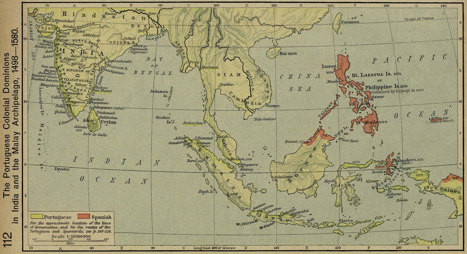
Creo que el mapa que has subido sobre el imperio español tendría que ser un mapa un poco mas claro y grande, algo así: http://upload.wikimedia.org/wikipedia/commons/1/19/BlankMap-World-large-noborders.png Por si te sirve de algo: Colonización de las Indias Orientales Españolas: http://www.lib.utexas.edu/maps/historical/shepherd/portugal_colonial_dominions.jpg Colonización de America en 1784 por encyclopedia Britannica incluye la Patagonia: http://media-2.web.britannica.com/eb-media/64/2064-004-0A19D73E.gif
Un saludo. Datiusnerva (talk) 05:34, 15 March 2009 (UTC)
hola
Gracias por responder, aunque el caso de la patagonia no es diferente al de los británicos en el norte de Canada. + Mapas orientativos (por si te sirven de algo):
Publisher: Times Books/HarperCollins Pulishers Spanish America by 1620 http://www.historyonmaps.com/ColourSamples/cbig/by1620.jpg
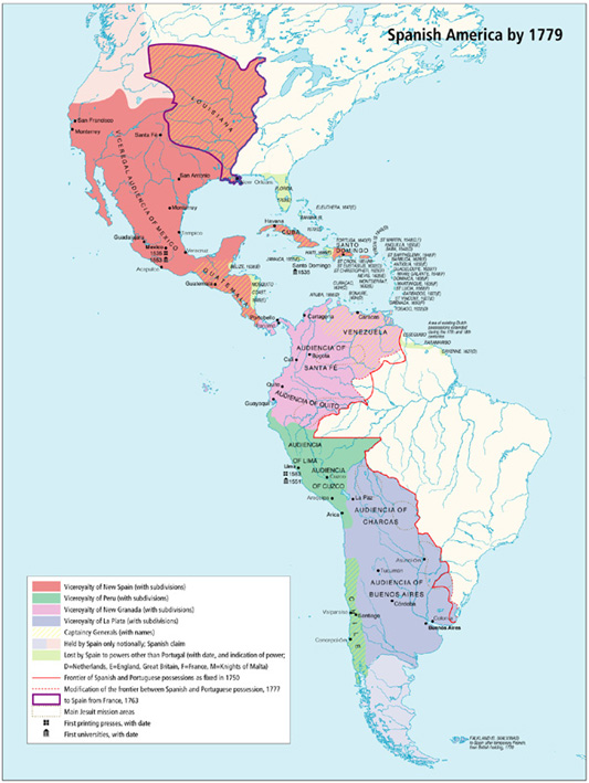
Publisher: Times Books/HarperCollins Publishers: Spanish America by 1779 http://www.historyonmaps.com/ColourSamples/big/by1779.jpg
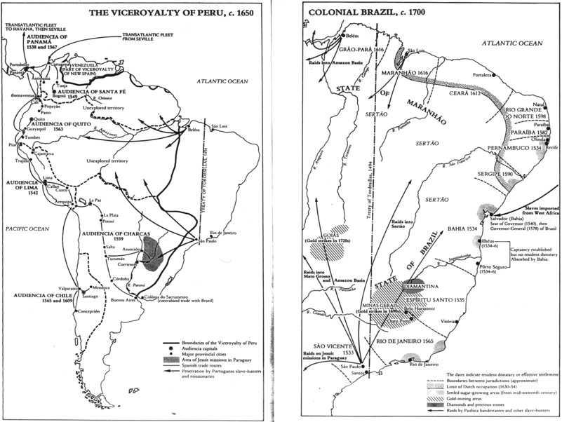
Publisher: Penguin Atlas UK Viceroyalty of Peru 1650 http://www.historyonmaps.com/BWSamples/big/PeruBrasil.jpg
El mapa que has creado es buenísimo! Pero yo opino que tiene demasiados colores y resulta un poco confuso Saludos! Datiusnerva (talk) 22:35, 21 March 2009 (UTC)
Spanish Empire
The socks are back. I reverted three times though so don't want to get myself blocked... The Red Hat of Pat Ferrick t 14:01, 22 March 2009 (UTC)
New Map
Looks great. One immediate comment - I'm not sure St Helena was ever a Portuguese territory. The Red Hat of Pat Ferrick t 23:05, 1 April 2009 (UTC)
- Yup - I'm aware of its use as a way-station, I just didn't think it is viewed as part of the Portuguese "Empire" per se, ie as Portuguese "territory". The Red Hat of Pat Ferrick t 00:29, 2 April 2009 (UTC)
Olá
Olá Trasamundo. De facto, não estou propriamente activo na wikipédia, ando cheio de trabalho e as edições no último mês foram mais uma espécie de intervalo. O mapa está bom. E as tuas respostas e fontes há muito que desfizeram as minhas dúvidas sobre esta questão. E o meu problema com os mapas e algumas das redacções anteriores, no fim de contas, devia-se as tentativas, não necessariamente malévolas, de impôr uma visão simplistas dos processos históricos que nos interessam. É pena não conseguires fazer um mapa animado - confesso a minha incapacidade técnica para o conseguir... Já agora, para quando a generalização do uso do teu novo mapa em todas as wikipédias (a começar pela espanhola)? O teu mapa é de longe muito melhor que todos os outros e, além da correcção propriamente histórica, tem também um elevado nível de correcção geográfica. É que, mesmo sem discutir a questão da "integração" entre os reinos ibéricos e suas colónias, as áreas coloniais tinham erros gigantesco, como por exemplo no do Brasil. Saudações! The Ogre (talk) 10:16, 9 April 2009 (UTC)
Cosialscastells
Trasamundo, I suggest you stop replying to Cosialscastells and any of his sockpuppets on the Spanish Empire page. You are just encouraging him by responding to him. The Red Hat of Pat Ferrick t 12:02, 10 April 2009 (UTC)
Iberion Union
Olá Trasamundo! Tudo bem? Podes dar uma olhadela na questão que pelos vistos me opõe a mim e a um outro editor sobre a questão da "Cidade-Capital da União Ibérica"... Não tenho certezas a respeito desta questão, mas a ideia que tenho é que o conceito nem sequer faz sentido! É um outro editor que insiste em colocar essa entrada (aproveitando para ser pouco educado comigo...). Obrigado e abraços! The Ogre (talk) 10:48, 19 August 2009 (UTC)
- Obrigado Trasamundo. Mais uma vez a tua erudição histórica (e bem documentada!) é uma lufada de ar fresco. E tens toda a razão em relação ás mudanças que defendes. Força! Até breve. The Ogre (talk) 15:41, 22 August 2009 (UTC)
Louis Alphonse, Duke of Anjou
Hi, I reverted your edit as it breached NPOV. It is true that the Spanish king claims the kingship of Jerusalem, but he is not alone in doing this, the French legitimist pretender is one of the others who likewise claim the title. For more information on the different claimants, see Kings of Jerusalem#Potential claimants today. Pevernagie (talk) 11:16, 18 September 2009 (UTC)
Talkback

Message added 22:40, 23 September 2009 (UTC). You can remove this notice at any time by removing the {{Talkback}} or {{Tb}} template.
Pevernagie (talk) 22:40, 23 September 2009 (UTC)
Some "mistakes" in the Spanish Empire map
Hi Trasamundo, I've seen this map and looks superb. However, I've got some comments. First there is a question? Why is Austria not included? It belong to the Monarchy until the abdication of Charles V? Is there any reason not to include it? Other comment relates to the Republic of Siena. It belonged briefly to Spain during the 16th century, before being sold to the Medici. Finally, the frontier between France and the Spanish Netherlands moved several tens of kilometers (possibly more than in the Roussillon, see details in Southern Netherlands). Finally, Minorca was British during almost a century. Would it be possible to update the map? Thank you --Ecemaml (talk) 00:14, 26 December 2009 (UTC)
- Hi, Trasamundo, thank you for your extensive explainations. I'll try to write in English, but will switch to Spanish if the concepts are too complex to be expressed in English. I wasn't aware of the complexity of the Austria issue, and therefore, your explaination was totally satisfactory for me. The same with regard to Siena and Minorca. With regard to the Spanish Netherlands, I have to recognize that your explainations didn't convince me... until I saw again the map and noticed that the pink colour was for territories lost due to the Treaty of Utrecht or before. I was refering to, for instance, to Artois, which was lost by the Treaty of the Pyrenees. So you (again) was right :-) On the other hand, after reviewing the map, I've got two additional comments: to which extent is it valid to talk about the Treaty of Utrecht-Baden given that the Treaty of Baden was signed between France and the Archduke Charles (the Holy Roman Empire)? Besides, why isn't Mazalquivir (Mers el-Kebir) included in the map since it was Spanish between 1505 and 1708 and between 1732 and 1792 (I guess that it could be masked by neighbour Oran, but they're two different places)? Best regards and happy new year --Ecemaml (talk) 22:54, 29 December 2009 (UTC)
- Hi, happy New Year :-)
- I see your point with regard to the Treaty of Baden, although it's not really much mentioned in the literature. On the other hand, my suggestion would be explicitly naming Oran and Mazalquivir as "Orán and Mazalquivir" while in the La Goleta case, it could be enough with a mention to Tunis, as La Goleta was just its port (not as in the previous case, where both cities, however very close to each other, were totally independent entities). Muchas gracias y un saludo --Ecemaml (talk) 23:16, 3 January 2010 (UTC)
Good comments as usual
Nice to see your comments at Spanish Empire--clear and strong as always! My proposal to make a 2 color version of your map was in part to see if it was really the colors that people objected to or whether it was something else (like a desire to have more land colored, which seems to be the case). Another reason was that I could see some benefit to having a "simpler" map in the infobox and putting your full map below, perhaps in a section "overview" of the empire's history, so the map could be shown larger and its details described and sourced better than could be done in the infobox. You've written about why you made the map the way you did, with many sources. At least some of this could be incorporated into the article. In other words, my proposal was only semi-serious, and had the aim of giving you map better prominence in the article. ..not that I have much time to do any of these things. Your comments today made me smile. Glad you are still around and ready to defend your excellent creation.
Someday soon I might ask you for some help in understanding some of the Spanish terms I've come across in learning about the exploration of the Pacific Northwest from Mexico; the Spanish terms for sailing vessels, naval ranks, and much else, do not translate into English very well. For example, in English sailing ships are defined by "sail plans" while in Spanish they seem to be defined by size, decks, and other things. So "goleta" tends to be translated as "schooner" even though a goleta could be a "brig" depending on its sails, etc. But, no questions right now, just thinking out loud. Pfly (talk) 15:32, 29 December 2009 (UTC)
- Hello, feliz año nuevo to you too! After reading your message to me I spent time trying to read some of the Spanish Wikipedia (using Google Translate, because my Spanish is very very poor). I tried to read the Spanish Empire talk page, but was unable to get far with my limited time. I was surprised to find the page Territorio de Nukta (Nootka Territory in translation). It is described as a vast territory and part of New Spain. The machine translation I read made it sound like a province, or territory, of New Spain. I had never heard the terms Nootka Territory or Territorio de Nutka. Was this "territory" in the sense of being a defined region within the political structure of New Spain, or was it just a term for a vague region that amounted to little more than a claim over unexplored lands? The page cites no sources.
- I understand your points about the problems that might arise if a two-color map was made. I had forgotten about the Portugal issues. And yes, if the two-color map I proposed were made it probably would be "opening the melon", as you put it (which sounds funny in English--probably something like the English phrase "opening a can of worms", which sounds even funnier when I think about it). I will leave things as they are. I don't have enough free-time to do much anyway.
- Like you I do not understand the "conspiratorial theories" ("conspiracy theories" would be a better term) and hurt sensibilities. I try to "assume good faith" in others, but it can be hard to do when reading the map criticisms. I can't help but wonder whether there are biases of nationalism. As an American who has never been to Spain or Britain and has little connection to either (except a shared language with Britain) I wonder--I know that historically there was animosity between Spain and Britain, and each tended to glorify its own achievements while dismissing the other--is this still a common mindset today? Some of the complaints about the Spanish Empire map compare it to the British Empire map as if there is some kind of historical contest about which empire was greater. It reminds me of the words "patriot" and "patriotism". I don't know if there are equivalent words in Spanish, but in English the words have strong implications of "my country is better than your country", which is a sad way to think about the world. "Patriotism" can even means "the people of my country are better/smarter/harder-working/more-creative/etc than the people of your country", which is an awful way to think about people--basically racist. I try to assume good faith, but sometimes can't help but wonder whether for some people these kinds of patriotism are more important than truth. I don't know how it is in Spain, but in America these kinds of patriotism sadly common and too-often seen as a positive thing. It makes me sad to see, and was especially abundant over the last decade. Hopefully the new decade will be better!
- I had a bit more I was going to write, but have to go. I spent way too much time trying to read the Spanish Wikipedia this evening! Happy new year to you. Pfly (talk) 09:19, 3 January 2010 (UTC)
- One more thing, on the Audiencia of Manila, here's an English source about its application to mainland China [15], and also, in the same book, some information about its powers [16], which included governing and legislative functions. Pfly (talk) 09:52, 3 January 2010 (UTC)
Multiple deletion in the Commons
Hola Trasamundo! Hope all is well with you. I'm writing to let you know about several delete proposal in the commons that may interest you. They are:
- Hahaharedhatofpatferrick.PNG
- SpanishEmpireanachronic.png
- CorrectoImperioEspañol.png
- SpanishEmpireHRE.PNG
- HispaniaRegnum-World.png
- Imperioespañol1402.PNG
- SpanishEmpire1975.PNG
- 666333.PNG
There are also some more maps that should be deleted. Hope you can give's your view. Cheers! The Ogre (talk) 16:23, 20 February 2010 (UTC)
Descubierta y Atrevida
Good ideas. Thanks! By the way, I started to look at that Patagonia question in English secondary sources and so they agree very much with what you have been saying. I will post some results soon. Pfly (talk) 23:37, 20 February 2010 (UTC)
Message in the Commons
Hello Trasamundo! you have a message here. Cheers! The Ogre (talk) 16:57, 6 March 2010 (UTC)
Núñez Gaona, Juan Pardo
Hello. Yes, there was a Spanish establishment or fort called Núñez Gaona, at Neah Bay (the post was sometimes called "Fuca"). I have a lot of information about it (I live about 100 miles, 160 km, from Neah Bay). It existed for four months. It was abandoned before its construction was finished. I thought it was too minor to include on your map. The full story about the Neah Bay post is complicated, but the basic idea is this: It was built as a replacement for Nootka, which was going to be ceded to Britain in 1792, by the terms of the Nootka Convention of 1790. For this reason the Spanish "Expedition of the Limits" (Expedición de Límites in Spanish, I think) sailed from San Blas in 1792. Juan Francisco de la Bodega y Quadra was in command overall and went to Nootka to meet George Vancouver and turn over the post there. Salvador Fidalgo went to Neah Bay and began to build the new post. Bodega had to wait months before Vancouver arrived at Nootka, and during that time Bodega decided not to cede the Nootka settlement--for many reasons. Within two or three months of Fidalgo's arrival at Neah Bay the post's fate was set: it was probably not needed. In truth, everything depended on the negotiations between Bodega and Vancouver. Vancouver arrived at Nootka in late 1792. Bodega and Vancouver negotiated over the fate of the post at Nootka but could not reach an agreement. At one point Bodega offered to cede Nootka to Vancouver in exchange for his recognizing the Strait of Juan de Fuca as the border. So the post at Neah Bay might have had a future. Vancouver rejected the offer--he even rejected the claim of Neah Bay as "an established Spanish settlement". Because the post at Neah Bay was not founded until after the Nootka Convention it did not have an effect on how to implement the convention, Vancouver argued. It was irrelevant. So, Bodega and Vancouver failed to reach an agreement. This meant the Nootka post remained Spanish, by default. It also meant there was no reason to keep Fidalgo's half-built post at Neah Bay. It would be expensive and give no advantage. After it was certain that Nootka would remain Spanish the Neah Bay post had no purpose. So Bodega told Fidalgo to take it apart and prepare to leave. In September 1792 Bodega went to Neah Bay. He assigned Fidalgo to be commandant of Nootka. Bodega reviewed the situation at Neah Bay and officially ordered it abandoned. The post at Neah Bay existed for precisely four months. When Fidalgo left he took everything he could. The native Makah reoccupied the place. Bodega officially granted the Makah whatever remained--some gardens and buildings. Neah Bay is a Makah Indian reservation today.
No one knows exactly what the Spanish post at Neah Bay looked like. Reports from people who visited do not agree on how many buildings there were and how they were arranged. For example, an American trader, Joseph Ingraham, wrote that "the settlement consisted only of a few huts and a tolerably good garden". Another American trader, John Boit of the Columbia Rediviva, wrote "the Spaniards have erected a Cross upon the beach, and had about ten houses and several good gardens." According to Spanish sources (which also differ over details), Fidalgo had his men clear a circular field "one musket shot" in radius. Buildings included barracks for the men, a blacksmith shop, a bakery, an oven, and a kiln. A palisade was built and four cannon mounted. Corrals were built for cows, sheep, hogs, and goats brought from San Blas. A vegetable garden was begun.
All of the above information comes from the book At the Far Reaches of Empire: The Life of Juan Francisco De La Bodega Y Quadra. Other sources agree, but this book is the most detailed source I know.
I wrote above that I thought Neah Bay was too minor for your map. That was my thought months ago, in reaction to some question about Spanish posts in the Pacific Northwest other than Nootka. But I have no strong opinion on the matter. The post was very short-lived, but it was briefly important, in a limited way. And it might have been very important if the events of 1792 had been different.
About Juan Pardo. I have read about his expeditions and forts, but it has been a long time and I have forgotten the details. I think his Fort San Juan, or Joara, is known to have been in western North Carolina. There was another fort at Chiaha in Tennessee. I'm not sure if the location of forts associated with Pardo are known with confidence. There might be a large amount of guesswork. I have some books with information about the topic. If I find anything useful I will write you a note. For now, I must sleep, good night! Pfly (talk) 08:20, 29 March 2010 (UTC)
Spanish Empire
I just noticed that the Spanish Empire page has been quiet for a long time now. Perhaps we drove off the riff-raff? Just a thought! Pfly (talk) 10:00, 22 July 2010 (UTC)
Hello Trasamundo! I though you might be interested in this discussion going on at Talk:List of Portuguese_monarchs#Counts are not kings. Cheers! The Ogre (talk) 12:45, 28 September 2010 (UTC)
Spanish possession
Hi again, Trasamundo. I've just read that a so-called marquisate of Finale in Italy (see here) was a fief of the Spanish monarchs until 1713. Would it be worthy to mention it somehow in the article of the Spanish Empire? Regards --Ecemaml (talk) 12:31, 18 October 2010 (UTC) Bold text