
User talk:Tradedia/Archive 1
| This page is an archive of past discussions. Do not edit the contents of this page. If you wish to start a new discussion or revive an old one, please do so on the current talk page. |
Welcome
|
A barnstar for you!

|
The Original Barnstar |
| Thanks for writing Randa Kassis; it's a fantastic article :). Keep up the good work! Ironholds (talk) 15:09, 4 May 2012 (UTC) |
Syria Civil war title
I have gone ahead and asked for an admin to intervene, see: Wikipedia:Administrators' noticeboard/Incidents#Syrian Civil War (2011–present) - Knowledgekid87 (talk) 02:03, 23 June 2012 (UTC)
- Thank you very much for putting my attention into this. I have added my comments and will abide by a restrained approach to this. But what is clear to me is that discussion has not been closed, so the original status quo and the original title should prevail for now until an admin, not an individual colleague, decides. Please see the new notice board created above where I have put my comments. werldwayd (talk) 03:20, 23 June 2012 (UTC)
- Thanks again for your timely intervention at the right time and in the right manner in this regard and putting my attention to this very grave matter. My faith is reinforced in that accuracy almost always wins (as it should) against "popular" and short-sighted ideological approach of some. I am very satisfied with the outcome and reverting to the very accurate title Syrian uprising (2011–present) rather than "civil war" that did have majority voting in discussions but was erroneously based on subjective look into things rather than the international media that continuously refers to it as an uprising. My firm conviction that even majority votes on talk pages should not be binding. I nominate that this discussion becomes a precedence to other talk pages where we don't automatically follow majorities but we rely basically on reliable and objective outside sources. Talk page votes may be taken into some consideration, but should never be the basis of final decision. Again thanks for you for your efforts and not descending into a war particularly with colleagues I7laseral and Doncsecz. werldwayd (talk) 20:57, 24 June 2012 (UTC)
Syrian Civil War – Do not yell!
This is acceptable. And do not yell. Doncsecztalk 05:57, 23 June 2012 (UTC)
Here we go again....
I asked the article Syrian uprising (2011–present) to be move protected and while I am in favor for the name change, I think that the article needs another week at least before this (A move discussion) should be brought up again. - Knowledgekid87 (talk) 23:12, 2 July 2012 (UTC)
Nomination of List of areas currently held by Syrian opposition for deletion
A discussion is taking place as to whether the article List of areas currently held by Syrian opposition is suitable for inclusion in Wikipedia according to Wikipedia's policies and guidelines or whether it should be deleted.
The article will be discussed at Wikipedia:Articles for deletion/List of areas currently held by Syrian opposition until a consensus is reached, and anyone is welcome to contribute to the discussion. The nomination will explain the policies and guidelines which are of concern. The discussion focuses on high-quality evidence and our policies and guidelines.
Users may edit the article during the discussion, including to improve the article to address concerns raised in the discussion. However, do not remove the article-for-deletion template from the top of the article. Basalisk inspect damage⁄berate 00:23, 9 July 2012 (UTC)
Your article
Delete the "no areas" from the list. A list of areas currently held by the opposition should not include a list of area not held by the opposition. Zenithfel (talk) 01:11, 9 July 2012 (UTC)
Syria
What is the problem? You can click on the source and show by yourself that both Arhar al sham and Sukur al-Sham are fighting against the Syrian army. I have demonstrated on talk page that they were notable and among the strongest forces on the ground. Be constructive , not disruptive. --DanielUmel (talk) 21:31, 6 August 2012 (UTC)
Disambiguation link notification for August 31
Hi. Thank you for your recent edits. Wikipedia appreciates your help. We noticed though that when you edited Cities and towns during the Syrian civil war, you added links pointing to the disambiguation pages Checkpoint and Battle of Aleppo (check to confirm | fix with Dab solver). Such links are almost always unintended, since a disambiguation page is merely a list of "Did you mean..." article titles. Read the FAQ • Join us at the DPL WikiProject.
It's OK to remove this message. Also, to stop receiving these messages, follow these opt-out instructions. Thanks, DPL bot (talk) 17:30, 31 August 2012 (UTC)
Talkback

You can remove this notice at any time by removing the {{Talkback}} or {{Tb}} template.
--Al Ameer son (talk) 01:48, 18 February 2013 (UTC)
Hi Tradedia, Zozo2kx has provided some very relevant information regarding the administrative divisions of Damascus on my talk page. --Al Ameer son (talk) 07:23, 6 March 2013 (UTC)
Wikilinks in the uprising map
Hi Tradedia, whenever you have time, could you fix the wikilinks to Basatin al-Assad, al-Bayda, Tartus Governorate (site of recent massacre) and Marqab in the uprising map of the Cities and towns of the Syrian civil war article? I tried a couple days ago, but wasn't successful. Cheers! --Al Ameer son (talk) 22:51, 7 May 2013 (UTC)
 Done Tradediatalk 03:21, 8 May 2013 (UTC)
- Thanks for being so quick ;) Cheers --Al Ameer son (talk) 04:12, 8 May 2013 (UTC)
Updates for map
Village Abel: 11 May, rebels recaptured Abel, potentially easing the movements of opposition forces between al-Qusayr and Homs. Strategic village will help ease rebels' movement. However, the military captured it once again the very next day.Homs province 5 92.113.70.0 (talk) 14:33, 17 May 2013 (UTC)
Aleppo province: On 6 May regime forces took over the village of Harbeel. Regime forces took over several villages in south Reef Aleppo last night, after violent clashes particularly around the village of Hadadeen, which caused the death of several fighters on both sides.https://www.facebook.com/syriaohr/posts/366598120115199 92.113.70.0 (talk) 14:33, 17 May 2013 (UTC)
Mapmaking
Hey, I've been working on a solution to the current mess in the Rif Dimashq area. I've taken what we have currently and adjusted it to be closer to the actual geographical positions, you can see it here. Right now I'm collecting sources to fill in the Eastern Ghouta so as to avoid the controversial "star", maybe a few other towns in the region if sources can be found.
As I've been creating this, I got to thinking: Perhaps for overcrowded provinces, we can make enlarged maps to better show the finer details that can be accessible by clicking the capital names on the main map. We'd remove all but the nahiyah seats and maybe a few key bases/towns on the main map (satisfying those who think the map should be stripped down and/or kept the same size), and transfer all the fine details to the larger provincial maps (satisfying those who want detail and/or an enlarged map). It would also make editing easier, as one wouldn't need to sift through as many points to add new places. We could break it down as follows: Damascus/Rif Dimashq ; Aleppo ; Homs ; Hama ; Lattakia/Tartus ; Quneitra/Daraa/Suwayda ; Raqqa/Deir ez-Zor/Hasakah. Thoughts? ~~ Lothar von Richthofen (talk) 00:05, 13 August 2013 (UTC)
- Progress continuing here now. ~~ Lothar von Richthofen (talk) 02:48, 13 August 2013 (UTC)
- Great job on the “new” Rif Dimashq area! It could not have been done without the size increase, so I am sold on that. I volunteer to adjust aleppo area (soon after the size increase is implemented) and other areas as needed (over time). By the way, have you seen this? It has a map on it that might be useful as a source…
- I prefer to have everything in one map. There is already a simplified map in the main article for those who want that. Sometimes, I like to see the border area between provinces (like hama-idlib with Khan Shaykhun & kafr nabudah; or daraa-Rif Dimashq to see how rebel push in daraa might spillover into damascus; etc…) Also, if we have a simple main map and another detailed provincial one, then if we want to change the status of an important town, we have to do it in each map. And if we do it in one, but forget in the other, then we end up with inconsistencies… Tradediatalk 00:14, 14 August 2013 (UTC)
- I've seen that ISW report, but I have to say I'm a bit sceptical of it. I have not seen reports of clashes in the districts of central Damascus that it claims are contested, nor are they backed up in the report itself. Likewise for rebel control of upper Wadi Barada (upper left), which is too close to major military installations to be believable.
- Fair enough. I may retain some provincial/regional copies in my userspace so that I can better organise points.
- I'll enlarge it now, as I'd like to get the peanut gallery off my back quickly on the Ghouta matter.... ~~ Lothar von Richthofen (talk) 14:03, 14 August 2013 (UTC)
September 2013
![]() Hello, I'm BracketBot. I have automatically detected that your edit to Cities and towns during the Syrian civil war may have broken the syntax by modifying 1 "[]"s. If you have, don't worry, just edit the page again to fix it. If I misunderstood what happened, or if you have any questions, you can leave a message on my operator's talk page.
Hello, I'm BracketBot. I have automatically detected that your edit to Cities and towns during the Syrian civil war may have broken the syntax by modifying 1 "[]"s. If you have, don't worry, just edit the page again to fix it. If I misunderstood what happened, or if you have any questions, you can leave a message on my operator's talk page.
- List of unpaired brackets remaining on the page:
- cite web|url=https://www.facebook.com/syriaohr/posts/411545698953774 |title=Idlib province: Rebels (from Ahrar... - Syrian Observatory for Human Rights |publisher=Facebook |date= |accessdate=2013-08-
- |[[[Homs District]]
Thanks, BracketBot (talk) 04:40, 3 September 2013 (UTC)
Removal of Syrian civil war map
I can understand the reasons for deleting it from the Cities and towns during the Syrian civil war article, but the link is not enough, a schematic general map of Syria must be included to have a first and general vision of the military situation. Perhaps a map showing only territorial divisions (SAA and allies-held, FSA and allies-held, YPG and allies-held, and contested areas) without cities, towns, military bases or other infrastructures.--HCPUNXKID (talk) 17:48, 22 November 2013 (UTC)
1 Revert rule
Don't break the 1 revert rule, as you did just now, self-revert. And this source Yalla Souriyapro opposition blog and is not a reliable source.Hanibal911 (talk) 07:08, 18 December 2013 (UTC)
I may be partly wrong. But I added a 14th Regiment correctly as there is now an army offensive and the area near the town of An Nabk under army control.Hanibal911 (talk) 07:49, 18 December 2013 (UTC)
You're a bastard Pro-Assad. YoYou're a bastard Pro-Assad. Your mother ate my penis. You're on the verge of death.ur mother ate my penis. You're on the verge of deatYouYou're a bastard Pro-Assad. Your mother ate my penis. You're on the verge of death.'re a bastard Pro-Assad. Your mother ate my penis. You're a bastard Pro-Assad. Your mother ate my penis. You're on the verge of death.You're on the verge of death.h.You're a bastard Pro-Assad.You're a bastard Pro-Assad. Your mother ate my penis. You're on the verge of death. Your mother ate my penis. You're on the verge ofYou'rYou're a bastard Pro-Assad. Your mother ate my penis. You're on the verge of death.e a bastard Pro-Assad. Your mother ate my penis. YYou're a bastard Pro-Assad. Your mother ate my penis. You're on the verge of death.ou're on the verge of death. death.You're a bastard PrYou're a bastard Pro-Assad. Your mother ate my penis. You're on the verge of death.o-Assad. Your mother ate my penis. You're on the verge of death.
Regarding the Syrian civil war map
ok Tradedia I will leave it to you. Thanks. --Barcaxx1980 (talk) 09:54, 2 March 2014 (UTC)
Latakia
Good day! I want to ask you why you revert my changes on two villages in the province of Latakia, although I noted a reliable source confirming all my edits if the reason is that my source cites agency SANA then you need to also remove the village Bayt Ablak which added Alhanuty editor using the source data is based on opposition media. Also its source pointed out that the rebels occupied the city Bayirbucak but editor Alhanuty added on the map the village of Bayt Ablak argues that source was referring this particular locality. Hanibal911 (talk) 12:12, 27 March 2014 (UTC)
- Hi! The reason is because when SANA talks about "qualitative operations" it frequently means just air attacks or artillery strikes. This is not enough to make a town contested. This is especially that we don’t have other indications that the town is contested, in fact this is known to be a rebel stronghold and if it was contested, more news about that would appear in more media outlets. By the way, Turkish weekly is just using a Xinhua report. Xinhua is the state press agency of China. China state has been on the side of Syrian government. It is not a neutral source (see Xinhua_News_Agency#Credibility) and should be put at the same level as PressTV, Russia TV, etc… Tradediatalk 13:59, 27 March 2014 (UTC)
- But then we need to most Turkish media, Qatari channel Al Jazeera and the Saudi Arabia media classify as pro opposition sources, as these countries are supporting the opposition. And thank you for your detailed answer. Hanibal911 (talk) 15:59, 27 March 2014 (UTC)
- Well, this applies to state press agencies only. Many Turkish media are independent from the state and have a good reputation. Al Jazeera English cares about its reputation and is not so bad, although it is not as neutral and high quality as good reputation media, so we have to be careful. On the other hand, Al Jazeera Arabic is worse and has to be used with great care because it might overstate rebel successes. It is the same with the Saudi Channel Al Arabiya. Tradediatalk 17:59, 27 March 2014 (UTC)
- I absolutely agree with you. Hanibal911 (talk) 18:04, 27 March 2014 (UTC)
- But then we need to most Turkish media, Qatari channel Al Jazeera and the Saudi Arabia media classify as pro opposition sources, as these countries are supporting the opposition. And thank you for your detailed answer. Hanibal911 (talk) 15:59, 27 March 2014 (UTC)
Syrian civil war map
Hi, regarding your revert on April 2, i would like to bring to your attention that the map with thick lines #3 was modified and should now contain thin province borders (as required by yourself), see this. For some reason however, the system doesn't show the update yet. I will remove alternative on the template, when the system is loading map #3 properly. Thanks for your understanding. GreyShark (dibra) 21:43, 3 April 2014 (UTC)
Syrian Civil War general sanctions
As a result of a community decision, broad editing restrictions apply to all pages broadly related to the Syrian Civil War. These sanctions are described at Talk:Syrian Civil War/General sanctions and a brief summary is included below:
- Sanctions can be used against an editor who repeatedly or seriously fails to adhere to the purpose of Wikipedia, satisfy any standard of behavior, or follow any normal editorial process.
- If you inappropriately edit pages relating to this topic, you may be placed under sanctions, which can include blocks, a revert limitation, or a topic or article ban.
- A one revert per twenty-four hours restriction applies to articles broadly related to the Syrian Civil War, with the wording listed here.
- Please familiarise yourself with the full decision at Talk:Syrian Civil War/General sanctions before making any further edits to pages related to the Syrian Civil War.
- Sanctions imposed may be appealed to the imposing administrator or at the appropriate administrators' noticeboard.
This notice is effective only if given by an uninvolved administrator and logged at Talk:Syrian civil war/General sanctions#Log of notifications. Callanecc (talk • contribs • logs) 12:21, 10 April 2014 (UTC)
New ideas for the template map
I have a brand idea for the template syrian civil war map,instead of using the blank Syria map,we can create a new map,based on the Syria blank map,and in that map we will precisely draw the frontlines and show the territory that the four sides in the civil war map control,and then we will put the cities that the sides control over it, the same way of how we putted the cities over the blank Syria map,your thoughts are welcomed.Alhanuty (talk) 23:35, 23 April 2014 (UTC)
Any opinions ? Alhanuty (talk) 16:52, 25 April 2014 (UTC)
- Not sure. Seems similar to https://en.wikipedia.org/wiki/File:Syrian_civil_war.png Note that the colored areas on that map are probably approximate since it is hard to know who controls areas that are empty from dots. I suspect that the person who updates that map just looks at the colored dots that we put on the template detailed map and then figures out how to color the areas... Tradediatalk 06:09, 26 April 2014 (UTC)
I can do that it is easy for me to update the map without the dots.Alhanuty (talk) 17:09, 26 April 2014 (UTC)
Be coherent or I will act in consequence
Im starting to think you have some type of obsession against me, that's the only way to understand that you revert my edit including brigade 666 & 246 regiment in Damascus (basing on the argument that they werent specifically named in the map given as source), but at the same time you dont revert the edit by other user who includes the Military academy and artillery base near Waer & Homs (when the map given as source doesnt cite it specifically). That is a blatant double standard of different acting is equal situations, so you have two options: remove both or add both. You have 24 hours to do what you consider best, if not, I will resolve it. --HCPUNXKID 16:44, 13 May 2014 (UTC)
- PD. And about Hajana battalion in Raqqa, is well-known that Raqqa and its surroundings are totally controlled by ISIS, with the only exception of Division 17. That perhaps could be your only point to remove it, although is clear that is an ISIS-controlled base. But be sure that if I found bases in cities not contested (Latakia, Idlib, Hama, Suweyda, etc...) I will add them.--HCPUNXKID 16:44, 13 May 2014 (UTC)
Paolowalter and Al-Masdar
Paolowalter has recently changed the dots in Latakia based on Al-Masdar, can you please revert his edits there, because alot of Editors agree on Not using Al-Masdar for Pro-government advance. Alhanuty (talk) 02:48, 14 October 2014 (UTC)
Syria
I did not undo my previous actions. I filled in references and then merely marked dead references. Cheers.--Catlemur (talk) 20:12, 26 October 2014 (UTC)
Sorry, fixed. Catlemur (talk) 20:47, 26 October 2014 (UTC)
military base
I added these military objects (Army Facilities, Masakin al-Dumayr,Air Defense Base (Al Afteras), Army Radar Base) as they are in the territory which controlled by the army. See source and here these objects on the map Army Facilities Masakin al-DumayrAir Defense Base (Al Afteras)Army Radar Base So that you need put them back on the map, or after 24 hours, I'll do it myself. Regards! Hanibal911 (talk) 09:05, 12 November 2014 (UTC)
- @Hanibal911: There is a real problem with the military bases you added based on a name found on Wikimapia. The problem is that ANYONE can edit Wikimapia and put ANYTHING they like without any source or explanation. So in terms of finding military bases, Wikimapia is unreliable. I can go now to Wikimapia and put in Brigade 69 (Shaykh Yurbuty) in some random place. Then, I can come back and put it on our map. The problem is that Brigade 69 (Shaykh Yurbuty) does not exist, as I just invented it. That is why we need some source other than Wikimapia to mention the military base before we can put it on our map. In this case, any pro-gov or pro-rebel source is fine. Notice that our problem here is not about which party controls the area in question, but rather whether the military base exists or still exists.
- For all the above reasons, Wikipedia rules forbid using “wikis” (such as Wikimapia) as a source. Wikipedia rule WP:USERGENERATED is very clear. It states: “open wikis are largely not acceptable as a source. This includes any website whose content is largely user-generated.” This is exactly the case of Wikimapia, as users (anyone) generate the content. So Wikimapia can only be used to get coordinates for something that is already validly sourced. Tradediatalk 07:18, 13 November 2014 (UTC)
Good job!!!
You have removed the military bases I added although I have provided sources confirming my actions But why then you did not notice when the editor makes a change without identifying the source.here Regards! Hanibal911 (talk) 16:35, 6 December 2014 (UTC)
- @Hanibal911: No, you have not provided sources. What is required is a source indicating:
- 1) the existence of the military base and,
- 2) who controls it.
- You are focusing exclusively on item 2), which I have no problem with. I don’t disagree with you on who is in control of the area of the military base. My problem is with item 1). The source has to mention explicitly the military base, so that we know that it exists (or continues to exist or was not destroyed). The maps you have provided show who controls the area of the military base. This satisfies requirement 2). However, the maps do not show explicitly the military base, so they do not satisfy requirement 1).
- As an indication for the existence of the military base, you are using Wikimapia. However, Wikimapia cannot be used as a source. The reason is that anyone can edit Wikimapia and put anything they like without any source or explanation. So in terms of asserting the existence of military bases, Wikimapia is unreliable. I can go now to Wikimapia and put in “Tell Hanibal (Brigade 911)” in some random place. Then, I can come back and put it on our map. That is why we need some source other than Wikimapia to mention the military base before we can put it on our map. In this case, any pro-gov or pro-rebel source is fine. Notice that our problem here is not about which party controls the area in question, but rather whether the military base exists or still exists. In the past, there were military bases icons put on our map based on Wikimapia name and we discovered later from a journalistic source that they were destroyed and did not exist anymore. We want to avoid this kind of problem in the future because it hurts the reputation of our map.
- For all the above reasons, Wikipedia rules forbid using “wikis” (such as Wikimapia) as a source. Wikipedia rule WP:USERGENERATED is very clear. It states: “open wikis are largely not acceptable as a source. This includes any website whose content is largely user-generated.” This is exactly the case of Wikimapia, as users (anyone) generate the content. So Wikimapia can only be used to get coordinates for something that is already validly sourced. Tradediatalk 10:31, 7 December 2014 (UTC)
- Okay, you convinced me in the situation with military bases. But I think that you agree with me that it is not justified editing.here Hanibal911 (talk) 11:34, 7 December 2014 (UTC)
- @Hanibal911: I agree with you that this edit is not justified. I saw it, but decided to let someone else who is following closely the situation in Deir Ezzor revert it. I knew that an edit with no source will not have any chance of surviving… Tradediatalk 14:26, 7 December 2014 (UTC)
- Okay, you convinced me in the situation with military bases. But I think that you agree with me that it is not justified editing.here Hanibal911 (talk) 11:34, 7 December 2014 (UTC)
Care to comment?
Here? Boredwhytekid (talk) 13:50, 17 December 2014 (UTC)
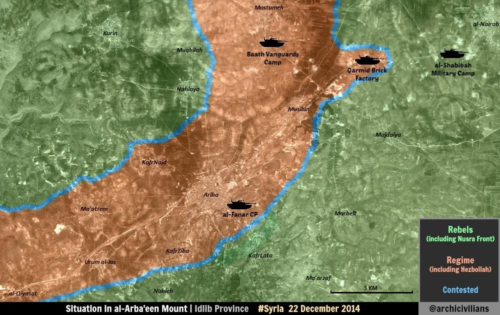
Al Fanar checkpoint
But pro opposition source clear showed that this checkpoint still present and controlled by army.here So that probably it was restored. Hanibal911 (talk) 11:35, 23 December 2014 (UTC)
- @Hanibal911: archicivilians is just an amateur mapmaker like us, so he might have missed that the checkpoint was already destroyed, because I could not find a mention for the checkpoint anywhere else beyond the date when it was destroyed. Tradediatalk 11:58, 23 December 2014 (UTC)
- But on 13 october 2014 the pro opposition source said that in Al-Arba'ain Mount revolutionaries destroyed a regime troops carrier in al-Fanar checkpoint.here But at the moment, this link does not work. But I will try find other evidence that this checkpoint still acts. Hanibal911 (talk) 12:24, 23 December 2014 (UTC)
- Hanibal911: Good. The source you linked shows that the checkpoint still exists today, so problem solved. Tradediatalk 23:29, 24 December 2014 (UTC)
- But on 13 october 2014 the pro opposition source said that in Al-Arba'ain Mount revolutionaries destroyed a regime troops carrier in al-Fanar checkpoint.here But at the moment, this link does not work. But I will try find other evidence that this checkpoint still acts. Hanibal911 (talk) 12:24, 23 December 2014 (UTC)
Dummy link parameters on location maps
In reply to User talk:Jackmcbarn/Archive 7#Clarifying my last edit on Syria map, the bug in question is now fixed, so any dummy link parameters can (and should) now be removed. Jackmcbarn (talk) 21:30, 7 January 2015 (UTC)
Halluz
Tradedia I raised this issue long ago when some twitter sources sayed that SAA captured the village and de-syracuse confirmed that to.hereLindi29 (talk) 15:15, 15 February 2015 (UTC)
- Lindi29: No, de-syracuse did not confirm it. He said: "Dec 15 : Loy. sources reported SAA captured Halluz village". So he is quoting "Loy. sources" which is pro-gov source and we cannot use it for pro-gov edits. He (de-syracuse) did not mark the town red, but marked it in the contested area (color brown-orange). Tradediatalk 21:42, 15 February 2015 (UTC)
Syria map users
We have a big problem. As long as the user "Hanibal" is blocked, many other users are now editing the map and breaking the rules constantly. They are using outdated rebel maps for rebel advances, tweets on twitter, hashtags etc, anonymous facebook sources etc. These are some of the users1, users2, source3 i have seen. I can't revert those edits because i always need to do it manually, and they always do it again and again. DuckZz (talk) 12:59, 17 June 2015 (UTC) i think this problem will be solved,report them,but i have realized an increase of pro-regime editors with a bias toward the government,after Pro-Regime Sockpuppet Deonis2012 got his latest sock Hannibal911 blocked.Alhanuty (talk) 13:11, 17 June 2015 (UTC)
- Again and again?? You need to chill, as we do not (to my knowledge) POV push "constantly." How am I supposed to know which sourced are pro-Syrian gov. or not? By the way, OpenStreetMap is a reliable source, as it has been used numerous times before (and happened to accurately report advances on the frontline). LightandDark2000 (talk) 13:30, 17 June 2015 (UTC)
Damascus map
I inserted a comment on the Damascus map talk page https://en.wikipedia.org/wiki/File_talk:Rif_Damashq.svg regardin your reverse of the latest map. Could you please comment on it?Paolowalter (talk) 19:49, 20 June 2015 (UTC)
On adding new villages
Hello Tradedia. This is concerning the issue of copying from amateur maps on the Syria-Iraq map. The villages I added to the map yesterday were not from a map per se; they were taken from coordinates and from Google maps satellite images. The geo coordinates were accurate, and depict villages held by ISIL.
This cannot violate the WP:CIRC rule, as is does not copy from Wikipedia, since the villages added were not previously present. Additionally, the addition of these villages doesn't not violate WP:RS, as the source for this edit was geo coordinates and satellite imagery, not an amateur map from an unknown user.
In the past, many dozens of villages have been added by looking at Google Maps imagery and adding the locations to the map. If you were to adhere to your interpretation of WP:RS rules, you would have to revert every single edit using a satellite map, which would wipe out most of the small villages and front lines. So I ask you please, to let my edit stand. Pbfreespace3 (talk) 15:01, 23 June 2015 (UTC)
- Pbfreespace3: What you have done, I call it “esthetic coloring”. It is basically putting icons in an area that we know who controls it unambiguously. It makes the map look prettier since there is more color. However, it doesn’t add much value, since we already know who controls that area. Also, it creates a major problem when there is a large enemy offensive which renders the area ambiguous (if the new front line becomes included in that area). Sources might not talk about these villages, which makes it hard to keep them updated. If no one is talking about them now (or in the past), then chances are no one will be talking about them in the future. We will then have to rely on control maps (to draw the front line) which have been found to be unreliable. You then get a front line that might be fake and based on the guess of some map maker. It is better to have front lines that are based on news information. These front lines might be more coarse, but they will be more truthful.
- You say: “you would have to revert every single edit using a satellite map, which would wipe out most of the small villages and front lines.” I agree that this would wipe out a lot of small villages. However, it will not wipe out front lines. The reason is that adding villages using a satellite map can only be done away from frontlines (areas where there is no ambiguity on who is in control). A front line can only be drawn based on a “text” source or a control map. Since “text” sources might not talk about small villages, we will then have to rely on control maps, which leads to the problem I mention above.
- If I want to get “legalistic” about it, I could say that your edit is unsourced, since you need a source telling us about who controls the villages in question (not just coordinates). If the source is a control map, then this would violate the rule that bans copying from maps. On the other hand, you did not provide a “text” source talking about these villages. Tradediatalk 12:35, 24 June 2015 (UTC)
- Fair enough. We will add the villages when we hear about them. Pbfreespace3 (talk) 14:59, 24 June 2015 (UTC)
Please review
Greetings! A quick request: is there anything you as an admin/creator of the Syria/Iraq maps can do to blunt the effect of unsupported edits? Especially when patterns emerge, such as users who refuse to discuss their actions/abide by the modules' rules. Point in case when this discussion was ignored. There's just too many unsupported edits made to revert [1], [2], [3], [4], [5], straight off of amateur maps, citing an Iranian source for an ISF advance, a source that doesn't even mention the town edited, using twitter and an amateur map, no discussion, citing a Reuters article that doesn't mention any of the towns edited..
Most of these edits remain in effect. 1RR kinda binds the hands; I'm hoping you have more leeway, and the inclination, to push back the tide. Boredwhytekid (talk) 13:03, 26 June 2015 (UTC)
I Need Help!
Someone on the Iraq map has been adding villages with an invalid source: https://en.wikipedia.org/w/index.php?title=Module:Iraqi_insurgency_detailed_map&action=history
The source used was a map: http://www.akb.bzh/spip.php?article889&lang=fr
You need to do something about this. This violates the rules. Pbfreespace3 (talk) 23:26, 27 June 2015 (UTC)

It may take a few minutes from the time the email is sent for it to show up in your inbox. You can at any time by removing the {{You've got mail}} or {{ygm}} template.
Formal mediation has been requested
The Mediation Committee has received a request for formal mediation of the dispute relating to "Cities and towns during the Syrian Civil War". As an editor concerned in this dispute, you are invited to participate in the mediation. Mediation is a voluntary process which resolves a dispute over article content by facilitation, consensus-building, and compromise among the involved editors. After reviewing the request page, the formal mediation policy, and the guide to formal mediation, please indicate in the "party agreement" section whether you agree to participate. Because requests must be responded to by the Mediation Committee within seven days, please respond to the request by 18 July 2015.
Discussion relating to the mediation request is welcome at the case talk page. Thank you.
Message delivered by MediationBot (talk) on behalf of the Mediation Committee. 04:46, 11 July 2015 (UTC)
Formal mediation has been requested
The Mediation Committee has received a request for formal mediation of the dispute relating to "Cities and towns in the war in Iraq and the Levant". As an editor concerned in this dispute, you are invited to participate in the mediation. Mediation is a voluntary process which resolves a dispute over article content by facilitation, consensus-building, and compromise among the involved editors. After reviewing the request page, the formal mediation policy, and the guide to formal mediation, please indicate in the "party agreement" section whether you agree to participate. Because requests must be responded to by the Mediation Committee within seven days, please respond to the request by 19 July 2015.
Discussion relating to the mediation request is welcome at the case talk page. Thank you.
Message delivered by MediationBot (talk) on behalf of the Mediation Committee. 02:59, 12 July 2015 (UTC)
Map broken
The map https://en.wikipedia.org/wiki/Cities_and_towns_during_the_Syrian_Civil_War is broken. Do you know how to fix it?Paolowalter (talk) 16:56, 18 July 2015 (UTC)
- @Paolowalter: (talk page stalker) It looks fine to me. What specifically is the problem? Jackmcbarn (talk) 17:11, 18 July 2015 (UTC)
Request for mediation rejected
The request for formal mediation concerning Cities and towns in the war in Iraq and the Levant, to which you were listed as a party, has been declined. To read an explanation by the Mediation Committee for the rejection of this request, see the mediation request page, which will be deleted by an administrator after a reasonable time. Please direct questions relating to this request to the Chairman of the Committee, or to the mailing list. For more information on forms of dispute resolution, other than formal mediation, that are available, see Wikipedia:Dispute resolution.
For the Mediation Committee, TransporterMan (TALK) 20:25, 19 July 2015 (UTC)
(Delivered by MediationBot, on behalf of the Mediation Committee.)
Qarqur
because,according to SOHR in both english and arabic reports the fighting have moved to Qarqur,which technically means that Regime force lost those two villages,plus alot of maps coming out show thwe same.Alhanuty (talk) 00:21, 31 July 2015 (UTC) Plus,this SOHR report confirms that they took the kafir area,which inlcudes those two villages,http://www.syriahr.com/en/2015/07/violent-clashes-and-attacks-target-regime-bastions-in-al-ghab-valley/Alhanuty (talk) 00:26, 31 July 2015 (UTC)
- Alhanuty: Take a look at the following map: https://twitter.com/karybdamoid/status/624108406358601728. You can see that Ghaniyah is not in Kufayr area. Look also at wikimapia Qarqur is south of Kufayr, whereas Ghaniyah is to the east of it. The rebels could go from Kufayr to Qarqur without passing by Ghaniyah. In fact, Ghaniyah is on a different parallel road to that of Kufayr-Qarqur. Also, Ghaniyah is as large as Kufayr, so it would have been mentioned in its own right.
- If you read the previous linked source, you can see that there is talk about a large rebel offensive in which Ghaniyah (among others) was allegedly taken before July 23. Here is the rebel announcement that is mentioned in the source and that talks about the offensive: http://rfsmediaoffice.com/en/2015/07/22/15769/#.VbvmlvntlBc So Ghaniyah was not taken with Kufayr a few days ago. However, I think it should be green because if it were gov-held, we would hear about fights around it in these last days, which is not the case… Tradediatalk 04:27, 3 August 2015 (UTC)
Deonis and Hannibal sockpuppet
i am suspecting that SambucaHOHOHO is his new sockpuppet,same attitude and thought and method of editing.i have opened a case here https://en.wikipedia.org/wiki/Wikipedia:Sockpuppet_investigations/Deonis_2012.Alhanuty (talk) 13:09, 4 August 2015 (UTC) an SPI has confirmed that the account belongs to Deonis 2012 AKA Hannibal911.User:AlAboud83 (talk) 15:42, 6 August 2015 (UTC) confirmed to be a sock,i also suspected another account to be his and an SPI proved it was his sock,https://en.wikipedia.org/wiki/User:Abu_Minyar_al-Gaddafi.Alhanuty (talk) 02:34, 16 August 2015 (UTC) Deonis 2012 again https://en.wikipedia.org/wiki/Special:Contributions/YokoHama.Alhanuty (talk) 22:45, 2 October 2015 (UTC)
Reporting an user
The user Pbfreespace3 is reverting edits on the "Syrian civil war map" because according to him, SOHR can't be used as a source, and therefore the map is outdated and nobody can make edits. DuckZz (talk) 18:26, 5 August 2015 (UTC) true DuckZz.Alhanuty (talk) 00:00, 6 August 2015 (UTC) can you add to the module that SOHR is a reliable source.Alhanuty (talk) 14:42, 9 August 2015 (UTC)
Reporting user SyrianObserver2015, he is a troll. He changed 12 locations without posting a source (usually we revert edits, but only if a user changed some small location, this time he changed major towns like Zabadani, Madaja without posting a source). DuckZz (talk) 14:28, 20 August 2015 (UTC) this user is an obvious troll and vandal.Alhanuty (talk) 16:11, 20 August 2015 (UTC)
The same user again trying to troll. He says 1 thing, but changed another, and even if he changed the first thing as he said, he still didn't provide a source. DuckZz (talk) 18:02, 25 August 2015 (UTC)
Again reporting the same user. I reverted his edit because he provided no source, then he manually reverted my edit because i provided no source for my revert what the hell ????. Again the same user provided no source, Al Masdar did not said anything about Al-Bahsa.
- Again the same user now doing edits on every name that starts with Al-Bahsa even if the location is completely wrong. Why don't you remove him from this map, he's playing dump, obviously an underage kid .... DuckZz (talk) 13:03, 27 August 2015 (UTC)
He calls you an ISIS fanboy, why do you tolerate him ? Also, he again broke the rules by editing locations which are not mentioned in the provided source. DuckZz (talk) 13:44, 6 September 2015 (UTC)
I'm sorry if you are off, but i really don't know if you're reading this, let me just know. DuckZz (talk) 18:58, 13 September 2015 (UTC)
Disambiguation link notification for September 13
Hi. Thank you for your recent edits. Wikipedia appreciates your help. We noticed though that when you edited Al-Ghab offensive (July–August 2015), you added a link pointing to the disambiguation page Mansura. Such links are almost always unintended, since a disambiguation page is merely a list of "Did you mean..." article titles. Read the FAQ • Join us at the DPL WikiProject.
It's OK to remove this message. Also, to stop receiving these messages, follow these opt-out instructions. Thanks, DPL bot (talk) 11:59, 13 September 2015 (UTC)
Issue on the Syrian map
This is concerning an issue on the Syrian location map. A recent dispute has occurred regarding the location of certain villages along the Euphrates River. It affects the location of villages on the Syrian Civil War wiki map. Without going into too much detail, suffice it to say that there is an issue in the map svg itself that needs to be resolved: The Euphrates river appears too thick near the border with Turkey. It is no longer a thick lake, but rather a river, partly due to water shortages. The river's size and shape needs to be adjusted to the current status of the river, which can be interpreted from satellite images. Presumably, not only the Syria location map but also 2 other maps which use this map also need to be updated. The goal of this requested change is to improve the reliability and accuracy of this map, and along with it, Wikipedia. I and the rest of the community would greatly appreciate it if you would update the map. I would do it myself, but I like the necessary equipment and expertise to edit and save SVG files. Thank you. Pbfreespace3 (talk) 23:15, 27 September 2015 (UTC)
Syria civil war map
Weird to see that you really lost interest in your map. DuckZz (talk) 16:57, 11 October 2015 (UTC)
It may take a few minutes from the time the email is sent for it to show up in your inbox. You can at any time by removing the {{You've got mail}} or {{ygm}} template.
SyrianObserver2015 is back in a new account SyrianObserver2016 and Also Deonis 2012 in Saypher99. Alhanuty (talk) 02:54, 23 October 2015 (UTC)