User:Talktovijay/sandbox
Somwarpet Taluk
ಸೋಮವಾರಪೇಟೆ ತಾಲುಕ | |
|---|---|
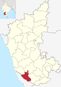
| Map of Somwarpet Taluka in the Kodagu District Map of Somwarpet Taluka in the Kodagu District | |
 Location in Karnataka | |
| Coordinates: 12°35′51″N 075°50′54″E / 12.59750°N 75.84833°E | |
| Country | |
| State | Karnataka |
| District | Kodagu district |
| Elected Representative(s) | MLA |
| Government | |
| • Type | Taluka Panchayat |
| • Body | Council |
| Area | |
| • Total | 1,003 km2 (387 sq mi) |
| Elevation | 609 m (1,998 ft) |
| Population (2011) | |
| • Total | 205,921 |
| • Density | 210/km2 (530/sq mi) |
| • Male Population | 102,739 |
| • Female Population | 103,182 |
| Sex Ratio | |
| Literacy Rate | |
| Area code | 08276 |
| Vehicle registration | KA-12 |
| No. of Villages | 135 |
Somawarpete taluk is one of the three talukas of Kodagu district. Its administrative headquarters is in the town of Somwarpet.

