From Wikipedia, the free encyclopedia
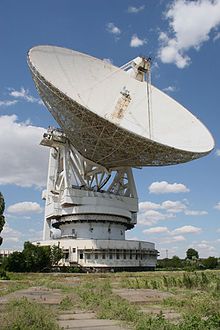
RT-70 70m diameter antenna in Yevpatoria Scientific measuring stations (Russian: Научно-измерительный пункт Soviet and Russian ground stations used to analyse, receive telemetry from and communicate with space craft . There are a number of these across the territory of the former Soviet Union.
Number
Location
Coordinates
Comments
NIP-1
site 18, Baikonur
45°54′31.47″N 63°19′52.79″E / 45.9087417°N 63.3313306°E / 45.9087417; 63.3313306 Example
NIP-2
Makat station, site 42, Baikonur
45°58′23″N 63°38′47″E / 45.97306°N 63.64639°E / 45.97306; 63.64639 Example
NIP-3
Sary Shagan 45°53′22.80″N 73°36′53.41″E / 45.8896667°N 73.6148361°E / 45.8896667; 73.6148361 Closed in 1993
NIP-4
Yeniseysk 58°26′55.63″N 92°15′58.61″E / 58.4487861°N 92.2662806°E / 58.4487861; 92.2662806 Operational
NIP-5
Turukhansky District , Krasnoyarsk Krai 63°2′10.83″N 88°7′25.70″E / 63.0363417°N 88.1238056°E / 63.0363417; 88.1238056 Closed in 1958
NIP-6
Yelizovo , Kamchatka Krai 53°6′5.29″N 158°21′33.26″E / 53.1014694°N 158.3592389°E / 53.1014694; 158.3592389 Operational
NIP-7
Kura 56°18′15.94″N 33°53′6.28″E / 56.3044278°N 33.8850778°E / 56.3044278; 33.8850778 Example
NIP-8
Bolshevo 54°58′16.44″N 36°15′33.44″E / 54.9712333°N 36.2592889°E / 54.9712333; 36.2592889 Operational
NIP-9
Krasnoye Selo 59°42′51.24″N 30°11′31.68″E / 59.7142333°N 30.1921333°E / 59.7142333; 30.1921333 Operational
NIP-10
Simferopol 45°3′18.54″N 33°53′6.28″E / 45.0551500°N 33.8850778°E / 45.0551500; 33.8850778 Closed in 1998,
NIP-11
near Tbilisi , Georgia
41°42′22.46″N 45°9′43.49″E / 41.7062389°N 45.1620806°E / 41.7062389; 45.1620806 Closed in 1988
NIP-12
Novosibirsk then Kolpashevo 58°20′12.4″N 82°53′11.4″E / 58.336778°N 82.886500°E / 58.336778; 82.886500 Closed in 2009
NIP-13
near Ulan-Ude
51°52′23.17″N 107°56′15.51″E / 51.8731028°N 107.9376417°E / 51.8731028; 107.9376417 Operational
NIP-14
Shchyolkovo 55°56′59.16″N 37°58′0.34″E / 55.9497667°N 37.9667611°E / 55.9497667; 37.9667611 Operational
NIP-15
Eastern Centre for Deep Space Communication , Primorsky Krai44°1′27.89″N 131°45′25.64″E / 44.0244139°N 131.7571222°E / 44.0244139; 131.7571222 Operational
NIP-16
Western Centre for Deep Space Communication , Yevpatoria 45°10′13.18″N 33°15′11.18″E / 45.1703278°N 33.2531056°E / 45.1703278; 33.2531056 Example
NIP-17
Yakutsk 61°58′32.91″N 129°39′14.16″E / 61.9758083°N 129.6539333°E / 61.9758083; 129.6539333 Operational
NIP-18
Vorkuta 67°33′30.39″N 64°9′43.11″E / 67.5584417°N 64.1619750°E / 67.5584417; 64.1619750 Operational
NIP-19
Dunaivtsi 48°51′25.04″N 26°42′25.41″E / 48.8569556°N 26.7070583°E / 48.8569556; 26.7070583 Example
NIP-20
Solnechny, Khabarovsk Krai
50°43′30.16″N 136°38′36.21″E / 50.7250444°N 136.6433917°E / 50.7250444; 136.6433917 Operational
NIP-21
Maydanak, Uzbekistan
38°41′06″N 66°57′08″E / 38.68500°N 66.95222°E / 38.68500; 66.95222 Operational, belongs to Uzbekistan
NIP-22
Yevpatoria
45°11′20.65″N 33°11′14.49″E / 45.1890694°N 33.1873583°E / 45.1890694; 33.1873583 Example
Wikimapia has NIP-5 in site 23, Baikonur at 45°42′15″N 63°20′24″E / 45.70417°N 63.34000°E / 45.70417; 63.34000
References [ edit ] {{reflist|colwidth=33em|refs=
[1]
http://www.mentallandscape.com/T_NIP.htm
http://www.svengrahn.pp.se/radioind/okik/okik.htm
http://www.russianspaceweb.com/kik.html
http://kik-sssr.narod.ru/Map_KIK_SSSR.htm

