
User:Mstev18/River Anticlines
River Anticlines[edit]
A River anticline is a geologic structure that is formed by the focused uplift of rock caused by high erosion rates from large rivers relative to the surrounding areas [1]. An anticline is a fold that is concave down, and whose limbs are dipping away from it's axis, and whose oldest units are in the middle of the fold[2]. These features form in a number of structural setting, and in the case of river anticlines, they form due to high erosion rates, usually in orogenic settings. In a mountain building setting, like that of the Himalaya or the Andes, erosion rates are high and the river anticlines fold axis will trend parallel to a major river. when river anticlines form, they have a zone of uplift between 50-80 kilometers wide, along the rivers that form them.[3]
The way that these structures form, deep river insisions and the associated crustal rebound, cause rocks deep in the crust to be preferentially exhumed along large rivers like the Arun, Indus, Sutlej, and Tsangpo[1]. This form of isolated exhumation could bring high pressure and ultra high pressure metamorphic sample to the surface at sustained rates of 5mm per year[4]. Analysis and radiometric dating of these high pressure and ultra high pressure metamorphic rocks can help reconstruct the tectonic evolution of the orogenic belt which formed them.[4]
The type of geologic feature that will form is based largely on the stream power and flexural rigidity of the crust. As stream power increases and flexuaral rigidity decreases, the structures progress from a transverse anticline to a river anticline then to a tectonic aneurysm in extreme cases[1]. Transverse anticlines trend in the direction of and form around small rivers with relatively high crustal strength[5]. River anticlines form around large highly erosive rivers where crustal strength is relatively low. And in extreme cases Tectonic aneurysms will form when erosion is very high and the crust is very weak, to form a structural welt[1]. These represent examples of interactions between erosion and tectonics.
Evidence
In the Himalaya for example, the Indian continental plate is crashing into the Eurasian continental plate with nearly north-south motion. Therefore the compression of the rocks in the Himalaya is in the north-south direction. So folding should occur trending east-west, and these do occur. However, there is also folding seen trending in the north-south direction. This could not be caused by the continent-continent collision because it is in the wrong orientation. It was noted that these folds follow the traces of the major rivers,like the Arun and the Indus. Originally these were explained by assuming that the rivers didn't form these anticline, instead the river's coarse was by coincidence on top of these geologic features, which formed by differential erosion[6]. This is when rocks are less durable and more prone to erosion, they will erode preferentially, and this could cause the river to flow over an anticline. The idea of isostatic rebound is suggested as the best fit mechanism for these north-south trending folds and is now widely accepted.[1]
Formation Processes
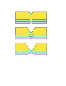
The formation of a river anticline by isostatic rebound is illustrated in the figure to the right in idealized steps. The principle of Isostasy says that if the lithosphere is free to move vertically, then it will float at an appropriate depth in the asthenosphere based on the thickness and density of the lithosphere. [2] River anticlines form when huge amounts of material are removed by river erosion in an area with low crustal rigidity. The crust rebounds up specifically along the river, while the rest of the area remains relatively constant. This will bend the crust forming an anticline, and can take up to ten thousand years[7]. As a river flows through the area, it erodes away large amounts of material and as the river erodes away the overlying rock, the lithosphere decreases in mass, causing an isostatic response. With no overlying rock, the underlying material rebounds up, like removing a weight from a raft. As the river progresses the erosion continues and therefore the rebounding continues, which will form a low wide antiformal structure. For this rebound to occur the erosion from the river must exceed the average erosion rate for the area and exceed the uplift of the orogen[1]. The average erosion rates for the Himalaya are about 1 mm per year, while the erosion rate for the Arun river of the eastern Himalaya is up to 8 mm per year[1][8], so it makes sense that we would see this structure along the Arun river.
Tectonic aneurysms
A tectonic aneurysm forms when uplift from local tectonics are combined with very weak crust and uplift from a river anticline, forming an isolated zone on the surface of extreme uplift and exhumation rates. When a major river flows over one of these areas, the erosion from the river will erode the material uplifted by tectonics as well by isostatic uplift. This will cause extremely rapid exhumation, up to 10mm per year, in along the Tsangpo river in the Himalayas[4]. Within the Himalaya there are two tectonics aneurysms each on one of the two syntaxis of the orogenic belt. Nanga Parbat in the west and Namche Barwa in the east[9][10]. These form similarly to river anticlines, but with extreme erosion rates and very weak and ductile crust. The syntaxis mark the end of the Himalyan orogen on either side and define the location of two large rivers, the Indus and Yalu Tsangpo, which flow through and help create them. In the west the Indus river flows through the Nanga Parbat and in the east the Yalu Tsangpo flows through the Namche Barwa. The very high erosion rates of these two rivers is coupled with weak, hot, thin, dry, crust[9] to form areas of extreme uplift and exhumation. The syntaxis on either side of the Himalaya are dominated by a strike slip fault zone, instead of a compressional thrust faulting, as in the rest of the orogen[10]
References[edit]
- ^ a b c d e f g Montgomery, David R.; Stolar, Drew B. (1 December 2006). "Reconsidering Himalayan river anticlines". Geomorphology. 82 (1–2): 4–15. doi:10.1016/j.geomorph.2005.08.021.
- ^ a b Marshak, Ben A. van der Pluijm, Stephan (2004). Earth structure : an introduction to structural geology and tectonics (2nd ed.). New York: Norton. pp. 353–354. ISBN 978-0-393-92467-1.
{{cite book}}: CS1 maint: multiple names: authors list (link) - ^ Robl, Jörg; Stüwe, Kurt; Hergarten, Stefan (20 June 2008). "Channel profiles around Himalayan river anticlines: Constraints on their formation from digital elevation model analysis". Tectonics. 27 (3). doi:10.1029/2007TC002215.
- ^ a b c Zeitler, Peter K. (january 2001). "Erosion, Himalayan geodynamics, and the geomorphology of metamorphism". GSA Today. 11: 4–9. doi:10.1130/1052-5173(2001)011<0004:EHGATG>2.0.CO;2.
{{cite journal}}: Check date values in:|date=(help); Unknown parameter|coauthors=ignored (|author=suggested) (help)CS1 maint: date and year (link) - ^ Simpson, Guy (1 January 2004). "Role of river incision in enhancing deformation". Geology. 32 (4): 341. doi:10.1130/G20190.2.
- ^ Burbank; McLean; Bullen; Abdrakhmatov; Miller (1 March 1999). "Partitioning of intermontane basins by thrust-related folding, Tien Shan, Kyrgyzstan". Basin Research. 11 (1): 75–92. doi:10.1046/j.1365-2117.1999.00086.x.
- ^ England, Phillip (december 1990). "Surface uplift, uplift of rocks, and Exhumation of rocks". Geology. 18 (12): 1173–1177. doi:10.1130/0091-7613(1990)018<1173:SUUORA>2.3.CO;2.
{{cite journal}}: Check date values in:|date=(help); Unknown parameter|coauthors=ignored (|author=suggested) (help)CS1 maint: date and year (link) - ^ Lavé, J.; Avouac, J. P. (1 January 2001). "Fluvial incision and tectonic uplift across the Himalayas of central Nepal". Journal of Geophysical Research. 106 (B11): 26561–26591. doi:10.1029/2001JB000359.
{{cite journal}}: CS1 maint: date and year (link) - ^ a b zeitler, P.K. (october 2001). "Crustal reworking at Nanga Parbat, Pakastan: metamorphic consequences of thermo-mechanical coupling facilitated by erosion". Tectonics. 5. 20 (5): 712–728. doi:10.1029/2000TC001243.
{{cite journal}}: Check date values in:|date=(help); Unknown parameter|coauthors=ignored (|author=suggested) (help)CS1 maint: date and year (link) - ^ a b Ding, Lin; Zhong, Dalai; Yin, An; Kapp, Paul; Harrison, T.Mark (1 October 2001). "Cenozoic structural and metamorphic evolution of the eastern Himalayan syntaxis (Namche Barwa)". Earth and Planetary Science Letters. 192 (3): 423–438. doi:10.1016/S0012-821X(01)00463-0.