This article is within the scope of the Greater Boston Public Transit WikiProject, a collaborative effort to improve Wikipedia's coverage of public transportation in the Greater Boston metropolitan area. If you would like to participate, you can visit the project page, where you can join the project and see a list of open tasks.Greater Boston Public TransitWikipedia:WikiProject Greater Boston Public TransitTemplate:WikiProject Greater Boston Public TransitGreater Boston Public Transit articles
This article is within the scope of WikiProject Trains, an attempt to build a comprehensive and detailed guide to rail transport on Wikipedia. If you would like to participate, you can visit the project page, where you can join the project and/or contribute to the discussion. See also: WikiProject Trains to do list and the Trains Portal.TrainsWikipedia:WikiProject TrainsTemplate:WikiProject Trainsrail transport articles
This article is within the scope of WikiProject National Register of Historic Places, a collaborative effort to improve the coverage of U.S. historic sites listed on the National Register of Historic Places on Wikipedia. If you would like to participate, please visit the project page, where you can join the discussion and see a list of open tasks.National Register of Historic PlacesWikipedia:WikiProject National Register of Historic PlacesTemplate:WikiProject National Register of Historic PlacesNational Register of Historic Places articles
This article is within the scope of WikiProject United States, a collaborative effort to improve the coverage of topics relating to the United States of America on Wikipedia. If you would like to participate, please visit the project page, where you can join the ongoing discussions.
OpposeWeak Oppose with the possibility of Support - Originally I was willing to consider suggesting a merger based on the photograph in the Wakefield Upper Depot picture. However the stations at this link which I added to the MBTA station article, not to mention a Google StreetView search, reminded me that the "Upper Depot" is apparently at the southeast corner of Tuttle and Chestnut Streets? BTW, we should invite User:Faolin42 in on this discussion. ----DanTD (talk) 22:03, 18 November 2010 (UTC)[reply]
So one question to resolve is whether Wakefield Upper Depot is the 1889 building or the 1950s building. Faolin42 (talk) 23:20, 18 November 2010 (UTC)[reply]
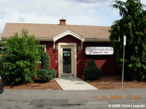
Here's what I've got from the link I mentioned; This is another image of the MBTA station, which is also the ReMax dealership. At the same time, here's the one said to be from the 1950's which is on the corner of Tuttle and Chestnut. Honestly, I would've thought the latter one was older, both due to the structure the style, and the apparent NRHP status. ----DanTD (talk) 23:37, 18 November 2010 (UTC)[reply]
As for the pictures of the platforms Faolin42 says he has; I know he offered to send them to me by e-mail and considered accepting them, but since you're now offering to post them here, I say go ahead. ----DanTD (talk) 23:48, 18 November 2010 (UTC)[reply]
Here's the images in a little mini-gallery Faolin42 (talk) 00:41, 19 November 2010 (UTC)[reply]
Showing the relationship a little more. I could convince myself that the 1950s station is at the far, far end of this row of buildings. But it's too fuzzy to be sure.
If you look in the picture on the left, you can see the corner of the station canopy and how the Re/Max old station building abuts the platform. The point of merging the two articles was because no matter which building at the station is on the national register, it is still the same station. This article is about the station, which includes the buildings that it consists of today and what it used to consist of. Grk1011/Stephen (talk) 01:38, 19 November 2010 (UTC)[reply]
I see that, and I understand the point of merging them, because I've done this plenty of times myself. I just wasn't 100% sure these two were worth merging. On the one hand Stephen, you and Faolin clearly know the area better than I do. On the other hand, there's still the issue of that other station house supposedly from the 1950's, which from what I've seen is now used as a bank/ATM shelter. If they are merged, the article is going to need some serious rewriting. Incidentally, that site has a link in the notes section, which is unfortunatley dead. ----DanTD (talk) 02:26, 19 November 2010 (UTC)[reply]
And I don't have a preference either way on the merge/don't merge. I'm more a picture guy than an editor. Faolin42 (talk) 02:42, 19 November 2010 (UTC)[reply]
Done, but I still have plenty of questions and doubts about this. ----DanTD (talk) 19:10, 1 December 2010 (UTC)[reply]
Looks good to me, thanks! I just updated the coordinates in the article to point to the Upper Depot building. As usual with the NRHP coordinates, they're off by half a block. Not sure why. Faolin42 (talk) 20:06, 1 December 2010 (UTC)[reply]
Many of the older NRHP coordinates are off by the same relatively short distance, in the same direction, in a given area, because they were measurements off the U.S. Geological Survey quadrant maps or other perfectly reliable sources for their time. But, the current geological system was changed in what is called the "North American Datum" change of 1983, which moved everything in the U.S. except near Chicago. Google maps and everyone else now uses the current system. Hope this helps or is interesting.... :) --doncram (talk) 18:56, 4 December 2010 (UTC)[reply]
MOVE TO CLOSE
This has been merged for more than a year. Can we, or should we close this thread? ----DanTD (talk) 01:04, 29 March 2012 (UTC)[reply]
The discussion above is closed. Please do not modify it. Subsequent comments should be made on the appropriate discussion page. No further edits should be made to this discussion.


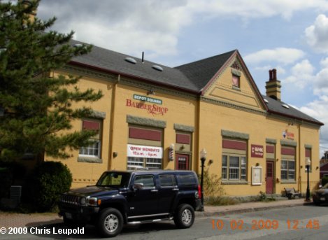
 I think this is the 1889 Wakefield Upper Depot
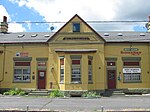 Front view of what I think is the 1889 Wakefield Upper Depot
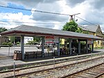 I think this is the modern Wakefield (MBTA station), such as it is...
 Showing the relationship a little more. I could convince myself that the 1950s station is at the far, far end of this row of buildings. But it's too fuzzy to be sure.


