
Talk:Paignton railway station
| This article is rated C-class on Wikipedia's content assessment scale. It is of interest to the following WikiProjects: | ||||||||||||||||||||||||||||||||||||||||
| ||||||||||||||||||||||||||||||||||||||||


New image[edit]
I added an image of what the station looks like today as this is suitable for the infobox. The 1970 image is still in the history section. --Ianmacm 12:30, 8 August 2007 (UTC)
New infobox image[edit]
I added a new infobox image, which unusually shows two trains at the station. There is a YouTube video showing the local train departing here.--♦IanMacM♦ (talk to me) 15:14, 3 August 2010 (UTC)
- Thanks, that's just what I was looking for!
- I'll move it over to Wiki Commons later this week, but if you have any more images it would help if you could upload them there yourself. That way they can be shared with other Wiki projects. Geof Sheppard (talk) 12:55, 4 August 2010 (UTC)
Gallery[edit]
A gallery was created because some of the images were whitespacing out the text excessively. Some of the gallery images are not very high quality and might be best left on Commons.--♦IanMacM♦ (talk to me) 18:07, 23 March 2011 (UTC)
Recent edits about the timetable[edit]
Due to the COVID-19 pandemic there are no printed rail timetables at the moment, and people are advised to check online before travelling. There is little point in going back and forth with edits that are basically original research. Please don't do this.--♦IanMacM♦ (talk to me) 06:46, 13 October 2020 (UTC)
Signal boxes[edit]
The article describes the north and south boxes at Paignton but I've discovered a photo from 1973 that appears to show a third box, then closed. Does anyone have any information about this one? Murgatroyd49 (talk) 14:21, 7 January 2023 (UTC)
- I'm old enough to remember the North (Woolworths) and South (Sands Road) boxes, but can't remember a third, or see it in a web search. Please could you upload/point to where the 1973 box is, thanks.--♦IanMacM♦ (talk to me) 17:16, 7 January 2023 (UTC)
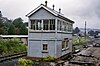 Here it is, by some carriage sidings. Murgatroyd49 (talk) 18:56, 7 January 2023 (UTC)
- Update, I think this might be Goodrington Sands box, which closed the previous year. Murgatroyd49 (talk) 21:32, 7 January 2023 (UTC)
- Yes, it's just outside Goodrington Sands railway station to the north of the bridge at Tanners Road. There is another photo here. While it is in Paignton, it isn't part of Paignton Railway Station.--♦IanMacM♦ (talk to me) 22:19, 7 January 2023 (UTC)
- Many thanks, couldn't find it on any map or on aerial photos so assumed it had been demolished. Murgatroyd49 (talk) 08:28, 8 January 2023 (UTC)
- It is no longer there. The Google Street View from 2009 shows that it was gone by then but it probably went well before that. It was still there in 1985 [1], looking better than it did in the 1973 photo.--♦IanMacM♦ (talk to me) 09:11, 8 January 2023 (UTC)
- Thanks Murgatroyd49 (talk) 10:47, 8 January 2023 (UTC)
- It is no longer there. The Google Street View from 2009 shows that it was gone by then but it probably went well before that. It was still there in 1985 [1], looking better than it did in the 1973 photo.--♦IanMacM♦ (talk to me) 09:11, 8 January 2023 (UTC)
- Many thanks, couldn't find it on any map or on aerial photos so assumed it had been demolished. Murgatroyd49 (talk) 08:28, 8 January 2023 (UTC)
- Yes, it's just outside Goodrington Sands railway station to the north of the bridge at Tanners Road. There is another photo here. While it is in Paignton, it isn't part of Paignton Railway Station.--♦IanMacM♦ (talk to me) 22:19, 7 January 2023 (UTC)
- Update, I think this might be Goodrington Sands box, which closed the previous year. Murgatroyd49 (talk) 21:32, 7 January 2023 (UTC)


![[1]](https://lookimg.com/images/2023/01/08/Q8ZYqe.jpg)
Distance from London to Paignton[edit]

Re this edit: 202 miles is considerably shorter than the 221 miles 74 chains quoted on the bridge outside Paignton railway station. There may be various ways of measuring the distance, but there needs to be a way of pointing out the discrepancy between the sources. ♦IanMacM♦ (talk to me) 14:31, 30 June 2023 (UTC)
- According to this site the distance on the bridge is "Paddington via Box". DuncanHill (talk) 14:41, 30 June 2023 (UTC)
- Mileposts between Cogload Junction (east of Taunton) and Plymouth are all measured along the original 'Great Way Round' via Box. Nearly all trains today take the direct route through Castle Cary which is about 20 miles shorter and has been used for more than 100 years.
- Nowhere in the article are the mileposts mentioned so I think the lead section is fine as it currently reads:
- It is 202 mi (325 km) from London Paddington along the most direct route.
- Things get even more confusing west of Plymouth as the mile posts record the distance via a reversal at the long-closed Millbay station and there are some other local variations. Geof Sheppard (talk) 20:05, 1 July 2023 (UTC)
- Re this edit: "Via Box" probably needs explaining for an average reader who is not a rail expert. In practice, this means that the modern timetable mileage and the milepost/bridge marker distance for the Paddington to Paignton rail distance are considerably different. Some sort of an editorial foot note may be needed here. There also needs to be consistency between articles, because Plymouth railway station is currently giving the shorter timetable distance. The Wikipedia Devon railway station articles shouldn't really be playing mix and match with the two different sets of figures. This could give the impression that Plymouth railway station is only four miles from Paignton, which it obviously isn't.--♦IanMacM♦ (talk to me) 09:51, 2 July 2023 (UTC)
- I'm trying to get it sorted out so that the articles are consistent, following a series of unsourced changes e.g. by 2A00:23C7:21C5:E001:44BB:9782:FC35:9E40 (talk). However, I do work five days a week (including Sundays), so it won't all get done at once. --Redrose64 🌹 (talk) 18:21, 2 July 2023 (UTC)
- The mileage figures are pretty much meaningless without explanation of how they are derived, including the route. My gut says timetable miles are more "realistic", for want of a better word, than milepost miles. Do we even need such a technical detail in the lead? DuncanHill (talk) 18:45, 8 July 2023 (UTC)
- And this is a pretty obscure page to have this discussion on. DuncanHill (talk) 18:46, 8 July 2023 (UTC)
- I'm trying to get it sorted out so that the articles are consistent, following a series of unsourced changes e.g. by 2A00:23C7:21C5:E001:44BB:9782:FC35:9E40 (talk). However, I do work five days a week (including Sundays), so it won't all get done at once. --Redrose64 🌹 (talk) 18:21, 2 July 2023 (UTC)
- Re this edit: "Via Box" probably needs explaining for an average reader who is not a rail expert. In practice, this means that the modern timetable mileage and the milepost/bridge marker distance for the Paddington to Paignton rail distance are considerably different. Some sort of an editorial foot note may be needed here. There also needs to be consistency between articles, because Plymouth railway station is currently giving the shorter timetable distance. The Wikipedia Devon railway station articles shouldn't really be playing mix and match with the two different sets of figures. This could give the impression that Plymouth railway station is only four miles from Paignton, which it obviously isn't.--♦IanMacM♦ (talk to me) 09:51, 2 July 2023 (UTC)