
Talk:Dʿmt
| This is the talk page for discussing Dʿmt and anything related to its purposes and tasks. This is not a forum for general discussion of the article's subject. |
Article policies
|
| Find sources: Google (books · news · scholar · free images · WP refs) · FENS · JSTOR · TWL |
| Archives: 1Auto-archiving period: 365 days |
| This article is rated Start-class on Wikipedia's content assessment scale. It is of interest to the following WikiProjects: | ||||||||||||||||||||||||||||||||||
| ||||||||||||||||||||||||||||||||||


Ethnic composition[edit]
Information about ethnic composition should be added. — Preceding unsigned comment added by 202.9.42.3 (talk) 13:01, 19 March 2016 (UTC)
Map[edit]
Doug Weller Stop reverting edits of the map. You are clearly not analysing everything carefully but looking at things vaguely.
- I am aware this is not Damot, Damot (what the upper text is referring to) was a kingdom found in Southern Ethiopia. It had no access to the sea and is not what the map is implying.
- Secondly, the map says Damot because it is using the vocalised form of how we say this kingdom in Ge'ez, Amharic, Tigrinya etc, I can speak one so I would know.
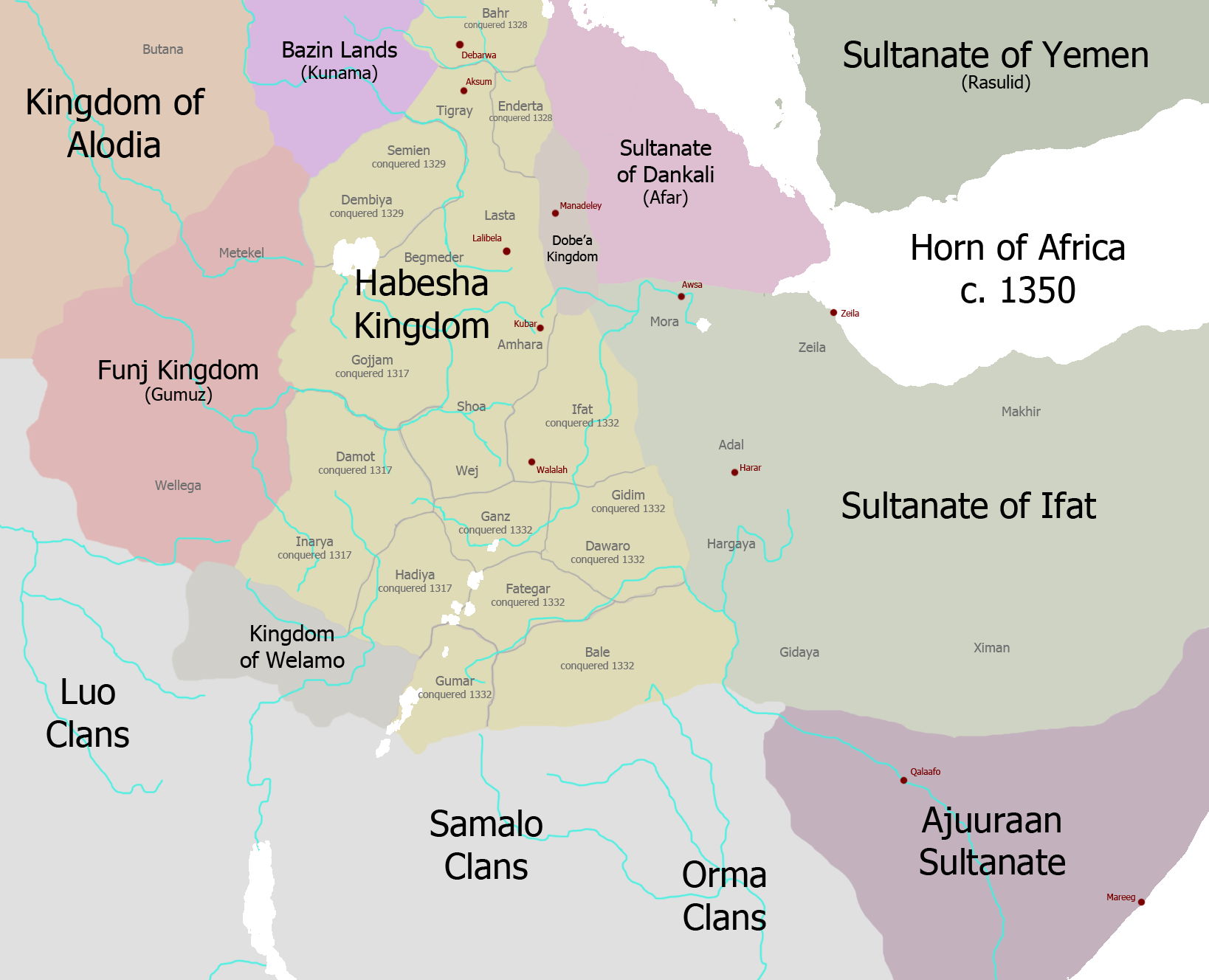
- Thirdly, if you done some extra reading, you'd figure out it cannot be Damot (southern empire) again because the kingdoms like Kush and Sheba did not exist at the time of Damot which was 1350, but existed with the D'mt kingdom, as the map shows. Take a look at this map of 1350 Ethiopia https://upload.wikimedia.org/wikipedia/commons/c/c3/Map_of_Ethiopia_circa_1350.png and take a good look as to where Damot was located, not D'mt.Resourcer1 (talk) 00:36, 6 March 2017 (UTC)
- @Resourcer1: I know that, you're telling me the reasons I removed it Why did you restore it?Doug Weller talk 06:27, 6 March 2017 (UTC)
- @Doug Weller: Why did you remove it for those reasons above if those are the reasons to keep it^?Resourcer1 (talk) 06:50, 6 March 2017 (UTC)
- @Resourcer1: The fact is that we don't even know if there was such a "kingdom". I'll start a new thread. Doug Weller talk 13:59, 6 March 2017 (UTC)
- @Doug Weller: Why did you remove it for those reasons above if those are the reasons to keep it^?Resourcer1 (talk) 06:50, 6 March 2017 (UTC)
Issues over the existence, status and boundaries[edit]
Relations between southern Arabia and the northern Horn of Africa during the last millennium BC Author(s): David W. Phillipson Source: Proceedings of the Seminar for Arabian Studies, Vol. 41, Papers from the forty-fourth meeting of the Seminar for Arabian Studies held at the British Museum, London,22 to 24 July 2010 (2011), pp. 257-265 Published by: Archaeopress Publishing Ltd.[1] states:
"The concept of a single ‘prc-Aksumite’ state (c.g. Fattovich 2004) in the northern Horn (whether or not called dmt) now appears very doubtful. Confirmed mentions of dmt in ancient inscriptions — in contrast with their prominence in historical reconstructions — are remarkably few and highly restricted both in geographical distribution and, apparently, in time span. In view of the radical reassessment — noted above — of the connotations of the word mkrb, it could even be questioned whether dmt actually was the name of a state. In any event, references to a single ‘pre-Aksumite* state on a south Arabian model, whether or not it was called dmt, are totally unwarranted. There can be no justification for applying the name dmt as a broad synonym for ‘pre-Aksumite’, as has recently been proposed (Finneran 2007: 117-118; cf. also Robin & dc Maigrct 1998: 789)."
On the other hand, we have The Development of Ancient States in the Northern Horn of Africa, c. 3000 BC—AD 1000:An Archaeological Outline Author(s): Rodolfo Fattovich Source: Journal of World Prehistory, Vol. 23, No. 3 (November 2010), pp. 145-175 Published by: SpringerStable URL: [2]
"The Pre-Aksumite Polity (c. 900/800-400 BC) The main indicators of this polity are the settlement pattern, as well as monumental architecture in a South Arabian style, sculptures, administrative devices, and inscriptions in South Arabian writing and a Sabean-like language, associated with Middle Pre-Aksumite and Matara II ceramic assemblages...The settlement pattern has been investigated only in central Tigray, where it was characterized by towns, villages, hamlets, and ceremonial centres (Michels 2005). A large settlement with two monumental temples and a cemetery with very rich shaft-tombs containing many prestige items (imported objects from Nubia, bronze and iron tools and weapons, bronze seals) was located at Ycha (Fig. 4). Another large settlement was located at Matara. The construction of small temples at the edge of the plateau overlooking the valleys sloping down to the lowlands may suggest that they were used as border markers (Fattovich 1990b). Administrative devices include zoomorphic and geometric bronze and clay seals, and suggest a widespread administration. Zoomorphic bronze seals, sometimes with personal names, were found only in the tombs at Yeha (sec Anfray 1963; D.W. Phillipson 2000a, pp. 350-351). Several inscriptions record the name of this polity: D*MT and four kings, as well as a division of the population into two main sections, the Reds and the Blacks. The inscriptions of the earliest two kings also record the names of their wives, suggesting that queens, too, had an important role (Drcwcs 1962; Schneider 1973, 1976; Marrassini 1985; Durrani 2005, pp. 123-124). A few inscriptions record the Sabcan title mukarib, which has been sometimes interpreted as a supreme king of a tribal federation (sec dc Maigrct 1996, pp. 190-192), but the correct meaning of this title is still uncertain (D.W. Phillipson 2009a).
Covering 'Dmt' (the spelling used) in great detail is The Archaeology of Ethiopia By Niall Finneran which discusses its status, eg "colony or independent state" [3] which refers to the belief that it was a South Arabian colony settled in Africa. P.118 discusses the spatial context but I still don't see enough detail to draw clear boundaries. Not surprisingly, the archaeological evidence simply isn't sufficient to show definite boundaries, although there about 100 sites "all sited in a core zone of the central-southern Eritrean highlands, and somewhat to the east of Aksum in the northern Ethiopian highlands (corresponding to the Eritrean Rore region and the Enderta region of Tigray)." This assumes Philippson is wrong. In any case, the map is extremely misleading about the extent of our knowledge and obviously the name. Doug Weller talk 14:18, 6 March 2017 (UTC)
- Doug Weller Read Foundations of an African Civilisation by Philippson. There is enough archaeological evidence on there, some artifacts and maps of which you will not even be able to find on the Internet. The map of the Ottoman Empire, British Empire or what have you is not exactly 100% accurate, yet they are still present on this site. There's is no point making a confusion about the name when it is clearly known the Damot kingdom you were referring to earlier was nowhere near the coast, this one is so it's obvious this is D'mt. The name is spelt differently everywhere because the Sabaean and Ge'ez language did not indicate vowels at the start.Resourcer1 (talk) 19:39, 16 March 2017 (UTC)
- I understand about spelling problems such as these, but you seem to have completely ignored the evidence that I give above that such boundaries are highly dubious, not just a bit inaccurate. The map misleads our readers. Doug Weller talk 13:42, 18 March 2017 (UTC)
- Doug Weller I have also provided evidence though. To say that this kingdom was non existent and remove its map is a bit far. No other areas further down south have similar artefacts to those found in Northern Tigray, Eastern Tigray and Eritrea. Inscriptions also proves this. I don't understand how the map 'misleads' readers, it's not like the kingdom encompassed the whole of Ethiopia and Eritrea, the map shows where it clearly was. Resourcer1 (talk) 22:48, 20 March 2017 (UTC)
- Firstly, Resourcer, what's your problem with this edit: [4]? It fixes a technical issue that has nothing do with your POV here. Look at the infobox with and without that change to understand what it does.
- Now in regards to the name, can you cite reliable sources that vocalize Dʿmt as Damot, please? SamEV (talk) 23:16, 20 March 2017 (UTC)
- I wasn't aware of that change, I can't see it in the infobox either so you may add it again, didn't realise I removed extra things. Secondly, it is not certain what the actual vowels were, I am sure "Da'mat" came through works on cognates, but as the script was an abjad then it was hard to tell. If possible the map can be changed to say "Dʿmt" and not Da'amat or Da'imot or any other combinations. My main concerns were the boundaries, not the nameResourcer1 (talk) 23:42, 20 March 2017 (UTC)
- 'Details' like these are very important when we're trying to write a serious encyclopedia. I think the right thing to do is remove the map until it can be modified. SamEV (talk) 01:14, 11 May 2017 (UTC)
- SamEV There is one spelling mistake of the 'o' at the end of D'mt, that is all on the map. Resourcer1 (talk) 09:41, 31 May 2017 (UTC)
- 'Details' like these are very important when we're trying to write a serious encyclopedia. I think the right thing to do is remove the map until it can be modified. SamEV (talk) 01:14, 11 May 2017 (UTC)
- I wasn't aware of that change, I can't see it in the infobox either so you may add it again, didn't realise I removed extra things. Secondly, it is not certain what the actual vowels were, I am sure "Da'mat" came through works on cognates, but as the script was an abjad then it was hard to tell. If possible the map can be changed to say "Dʿmt" and not Da'amat or Da'imot or any other combinations. My main concerns were the boundaries, not the nameResourcer1 (talk) 23:42, 20 March 2017 (UTC)
- Doug Weller I have also provided evidence though. To say that this kingdom was non existent and remove its map is a bit far. No other areas further down south have similar artefacts to those found in Northern Tigray, Eastern Tigray and Eritrea. Inscriptions also proves this. I don't understand how the map 'misleads' readers, it's not like the kingdom encompassed the whole of Ethiopia and Eritrea, the map shows where it clearly was. Resourcer1 (talk) 22:48, 20 March 2017 (UTC)
Proto-Geʽez? Geʽez[edit]
Where can I find info on proto-geʽez? And wouldn't calling it early Geʽez(if it is mutually intelligible) be better? Could it be the ancestor of the Northern Ethio-Semitic languages(Geʽez, Tigre, Tigrinya) — Preceding unsigned comment added by SonOfAxum (talk • contribs) 12:45, 29 November 2020 (UTC)
Why write protected? Correction needed[edit]
Hi! Why is this article write protected? There is an (albeit small) grammatical error around the word ”survive” in the 2nd sentence, that could ideally be corrected, thanks! Gunboz (talk) 01:55, 12 February 2022 (UTC)
- Start-Class Archaeology articles
- Mid-importance Archaeology articles
- Start-Class Africa articles
- Top-importance Africa articles
- Start-Class Eritrea articles
- Top-importance Eritrea articles
- WikiProject Eritrea articles
- Start-Class Ethiopia articles
- Top-importance Ethiopia articles
- WikiProject Ethiopia articles
- WikiProject Africa articles
- Start-Class former country articles
- WikiProject Former countries articles