
Silvolde
This article needs additional citations for verification. (April 2022) |
Silvolde | |
|---|---|
 Church: the Sint Mauritiuskerk | |
 Silvolde Location in the Netherlands  Silvolde Silvolde (Netherlands) | |
| Coordinates: 51°54′37″N 6°23′1″E / 51.91028°N 6.38361°E | |
| Country | Netherlands |
| Province | Gelderland |
| Municipality | Oude IJsselstreek |
| Area | |
| • Total | 11.98 km2 (4.63 sq mi) |
| Elevation | 17 m (56 ft) |
| Population (2021)[1] | |
| • Total | 5,220 |
| • Density | 440/km2 (1,100/sq mi) |
| Time zone | UTC+1 (CET) |
| • Summer (DST) | UTC+2 (CEST) |
| Postal code | 7064[1] |
| Dialing code | 0315 |
Silvolde (West Low German: Sillevolde) is a village in the Achterhoek and is part of the municipality Oude IJsselstreek.
School[edit]
There are several schools in Silvolde, those are:
- de Plakkenberg (elementary school)
- de Drie Linden (elementary school)
- de Bontebrugschool (elementary school)
- Bluemers (high school)
- Laudis (high school)
- Isala (high school)
Notable people from Silvolde[edit]
- Wim Mager (1940-2008), director of the Apenheul Primate Park
- Arne Jansen (1951-2007), Dutch singer
Gallery[edit]
-
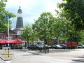 Silvolde market
 -
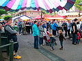 Summer market
 -
 Windmill in Silvolde
 -
 Horses


References[edit]
- ^ a b c "Kerncijfers wijken en buurten 2021". Central Bureau of Statistics. Retrieved 24 March 2022.
two entries
- ^ "Postcodetool for 7064AA". Actueel Hoogtebestand Nederland (in Dutch). Het Waterschapshuis. Retrieved 24 March 2022.
External information[edit]
Wikimedia Commons has media related to Silvolde.
| International | |
|---|---|
| National | |
| Geographic | |
This Gelderland location article is a stub. You can help Wikipedia by expanding it. |