
Portal:Western Australia
Introduction
 Western Australia (commonly abbreviated as WA) is a state of Australia occupying the western third of the land area of Australia, excluding external territories. It is bounded by the Indian Ocean to the north and west, the Southern Ocean to the south, the Northern Territory to the north-east, and South Australia to the south-east. Western Australia is Australia's largest state, with a total land area of 2,527,013 square kilometres (975,685 sq mi). It is the second-largest country subdivision in the world, surpassed only by Russia's Sakha Republic. the state has 2.76 million inhabitants—11 percent of the national total. The vast majority (92 percent) live in the south-west corner; 79 percent of the population lives in the Perth area, leaving the remainder of the state sparsely populated. The first Europeans to visit Western Australia belonged to the Dutch Dirk Hartog expedition, who visited the Western Australian coast in 1616. The first permanent European colony in what is today Western Australia occurred following the landing by Major Edmund Lockyer on 26 December 1826 of an expedition on behalf of the New South Wales colonial government.[text–source integrity?] Lockyer established a convict-supported military garrison at King George III Sound, at present-day Albany, and on 21 January 1827 he formally took possession for the British Crown of the western part of the continent that was not already claimed by the Crown. This was followed by the establishment of the Swan River Colony in 1829, including the site of the present-day capital, Perth. (Full article...)
|


.jpg)


(Northern
Territory) |
 Good articles -
-


Narrows Bridge
The Narrows Bridge is a freeway and railway crossing of the Swan River in Perth, Western Australia.
Made up of two road bridges and a railway bridge constructed at a part of the river known as the Narrows, located between Mill Point and Point Lewis, it connects the Mitchell and Kwinana Freeways, linking the city's northern and southern suburbs. The original road bridge was opened in 1959 and was the largest precast prestressed concrete bridge in the world. Construction of the northern interchange for this bridge necessitated the reclamation of a large amount of land from the river. (Full article...) -
The Causeway is an arterial traffic crossing in Perth, Western Australia, linking the inner-city suburbs of East Perth and Victoria Park. It is carried over the Swan River at the eastern end of Perth Water by two bridges on either side of Heirisson Island. The current Causeway is the third structure to have been built across the river at this point.
Originally the site of mudflats which restricted river navigation, the Colony Government constructed a causeway and bridge across the site. The project was first planned in 1834 and opened in 1843. When floods in 1862 almost destroyed it, the structure was rebuilt using convict labour, and raised to better withstand future floods. Governor John Hampton officially opened the new Causeway on 12 November 1867. Over the following decades, the three bridges making up this second Causeway were widened several times, and they were eventually replaced in 1952. (Full article...) -
Seaforth railway station is a suburban railway station in Gosnells, a suburb of Perth, Western Australia. It is on the Armadale line which is part of the Transperth network, and is 22.6 kilometres (14.0 mi) southwest of Perth station and 7.8 kilometres (4.8 mi) north of Armadale station. The station opened on 4 May 1948 with low level platforms. High level platforms were added in 1968. The station consists of two side platforms with a pedestrian level crossing. It is not fully accessible due to steep ramps and a lack of tactile paving.
Services are operated by the Public Transport Authority. Peak services reach seven trains per hour in each direction, whilst off-peak services are four trains per hour. The station is one of the least used ones on the Transperth network, with just 136 boardings per day in October 2017. Since November 2023, the station has been temporarily closed for construction of the Victoria Park-Canning Level Crossing Removal Project and the Byford rail extension. (Full article...) -
The Australian ringneck (Barnardius zonarius) is a parrot native to Australia. Except for extreme tropical and highland areas, the species has adapted to all conditions. Treatments of genus Barnardius have previously recognised two species, the Port Lincoln parrot (Barnardius zonarius) and the mallee ringneck (Barnardius barnardi), but due to these readily interbreeding at the contact zone they are usually regarded as a single species B. zonarius with subspecific descriptions. Currently, four subspecies are recognised, each with a distinct range.
In Western Australia, the ringneck competes for nesting space with the rainbow lorikeet, an introduced species. To protect the ringneck, culls of the lorikeet are sanctioned by authorities in this region. Overall, though, the ringneck is not a threatened species. (Full article...) -
Severe Tropical Cyclone Sam (JTWC designation: 03S) was an intense tropical cyclone that brought flooding rainfall to a wide swath of northern Australia in December 2000. The first tropical cyclone of the regional season, Sam originated from a tropical low that formed in the Arafura Sea on 28 November. Tracking generally westward, the initial low-pressure area remained generally weak until it entered the Timor Sea, by which time it had strengthened into a tropical cyclone on 5 December. Though a subtropical ridge was forcing the cyclone westward at the time, an approaching shortwave trough caused Sam to track southward the following day, towards the Australian coast. During its southward progression, Sam rapidly intensified, and reached its peak intensity on 8 December. Soon afterwards, the storm made landfall near Lagrange, Western Australia at the same intensity. Once inland, Sam was slow to weaken as it re-curved eastward, and persisted for nearly a week inland before dissipating on 14 December.
Throughout its existence, Cyclone Sam brought heavy rainfall to a wide swath of northern Australia. Rainfall peaked at 520 mm (20 in) in Shelamar over a 48-hour period ending on 11 December. Upon making landfall, damage was considerable, albeit localized. Most of the destruction wrought by Sam occurred near the coast, particularly in Bidyadanga and Anna Springs Station. Some buildings sustained considerable damage, and trees and power lines were felled, resulting in some power outages. Offshore, 163 illegal immigrants aboard two vessels were feared to have drowned, which would make Sam one of the deadliest cyclones in Australian history. However, these people were later accounted for. After the season, the name Sam was retired from the regional naming list. (Full article...) -
North West Coastal Highway is a generally north-south Western Australian highway which links the coastal city of Geraldton with the town of Port Hedland. The 1,300-kilometre-long (808 mi) road, constructed as a sealed two-lane single carriageway, travels through remote and largely arid landscapes. Carnarvon is the only large settlement on the highway, and is an oasis within the harsh surrounding environment. The entire highway is allocated National Route 1, part of Australia's Highway 1, and parts of the highway are included in tourist routes Batavia Coast Tourist Way and Cossack Tourist Way. Economically, North West Coastal Highway is an important link to the Mid West, Gascoyne and Pilbara regions, supporting the agricultural, pastoral, fishing, and tourism industries, as well as mining and offshore oil and gas production.
In Geraldton, the highway begins at a grade separated interchange with Brand Highway and roads providing access to the port and town centre. Two major roads link the North West Coastal Highway to the inland Great Northern Highway: Geraldton–Mount Magnet Road in Geraldton, and Nanutarra Munjina Road at Nanutarra, 845 kilometres (525 mi) further north. Several roads link provide access to coastal towns and attractions, including Shark Bay Road, Onslow Road and Karratha Road. With few towns on the highway, roadhouses are the only settlements for long stretches. North West Coastal Highway ends at Great Northern Highway, 30 kilometres (19 mi) out from Port Hedland. (Full article...) -

Henry Daglish (18 November 1866 – 16 August 1920) was an Australian politician who was the sixth premier of Western Australia and the first from the Labor Party, serving from 10 August 1904 to 25 August 1905. Daglish was born in Ballarat, Victoria, and studied at the University of Melbourne. In 1882, he worked as a mechanical engineer but soon switched to working in the Victorian public service. He first stood for election in 1896 but failed to win the Victorian Legislative Assembly seat of Melbourne South. He then moved to Subiaco, Western Australia, where he found work as a chief clerk in the Western Australian Police Department. In 1900, Daglish was elected to the Subiaco Municipal Council and in April the following year, he was elected to the Western Australian Legislative Assembly as the member for the newly created seat of Subiaco, becoming one of six Labor members in the Western Australian Legislative Assembly. The party elected him as its whip, and he resigned from the Subiaco council on 1 May 1901. On 1 December 1902, Daglish was sworn in as mayor of Subiaco, having been elected the previous month.
In the 1904 state election, Labor won 22 of the Legislative Assembly's 50 seats, making it the party with the most seats. On 8 July 1904, the Labor Party caucus elected Daglish as the party's leader, and on 10 August, he successfully moved a motion of no confidence in the government of Walter James, who resigned as premier. Governor Frederick Bedford then swore in Daglish as premier of Western Australia, colonial treasurer and minister for education. His keynote speech on 23 August was poorly received; militant Labor supporters saw him as giving up on Labor policies. In parliament, Daglish struggled to achieve anything due to a hostile Legislative Council; his one major success was the passing of a new Public Service Act. In June 1905, a cabinet reshuffle decreased Daglish's popularity within the Labor Party but he defeated a motion of no confidence at a caucus meeting later that month. Daglish resigned as premier on 22 August 1905 when his plan to buy the Midland Railway Company for £1.5 million (equivalent to AU$126,500,000 in 2022) failed to pass through parliament. Hector Rason succeeded him as premier on 25 August. (Full article...) -
108 St Georges Terrace or Palace Tower (formerly known as the South32 Tower, the Bankwest Tower, the Bond Tower and the R&I Tower) is a 50-storey office tower in Perth, Western Australia. Completed in 1988, the building measures 214 metres (702 ft) to its roof and 247 metres (810 ft) to the tip of its communications antenna. It was the tallest building in Perth from its completion in 1988 until 1992 when it was overtaken in height by Central Park. As of 2023, it is the third-tallest building in the city. The concrete tower has a distinctive profile, with a triangular plan.
The site occupied by the tower was home to the Palace Hotel, and organised opposition was formed to try to save that building from demolition to make way for an office tower. The site was subsequently acquired by businessman Alan Bond and the tower was approved and constructed in a plan that would retain much of the Palace Hotel. The tower then remained the headquarters of Bond's companies until their collapse. The tower has also been the headquarters of Bankwest (formerly known as the R&I Bank), between its completion and 2012. In 2015, it became the headquarters of mining company South32. (Full article...) -
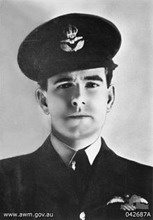
Air Commodore Sir Hughie Idwal Edwards, VC, KCMG, CB, DSO, OBE, DFC (1 August 1914 – 5 August 1982) was a senior officer in the Royal Air Force, Governor of Western Australia, and an Australian recipient of the Victoria Cross, the highest decoration for gallantry "in the face of the enemy" that can be awarded to members of the British and Commonwealth armed forces. Serving as a bomber pilot in the Royal Air Force (RAF), Edwards was decorated with the Victoria Cross in 1941 for his efforts in leading a bombing raid against the port of Bremen, one of the most heavily defended towns in Germany. He became the most highly decorated Australian serviceman of the Second World War.
Born in Fremantle, Western Australia, Edwards joined the Royal Australian Air Force in 1935, and a year later was granted a short service commission with the RAF. Serving throughout the Second World War, he gained a permanent commission and continued his career in the RAF after the war; he retired in 1963 with the rank of air commodore. Returning to Australia, he was appointed Governor of Western Australia in 1974. (Full article...) -
Great Northern Highway is an Australian highway that links Western Australia's capital city Perth with its northernmost port, Wyndham. With a length of almost 3,200 kilometres (2,000 mi), it is the longest highway in Australia, with the majority included as part of the Perth Darwin National Highway. The highway, which travels through remote areas of the state, is constructed as a sealed, predominantly two-lane single carriageway, but with some single-lane bridges in the Kimberley. Economically, it provides vital access through the Wheatbelt and Mid West to the resource-rich regions of the Pilbara and Kimberley. In these areas, the key industries of mining, agriculture and pastoral stations, and tourism are all dependent on the highway.
In Perth, the highway begins in Midland near Great Eastern Highway, and further north intersects the Reid and Roe highways, which together form Perth's ring road. There are also three rural highways that spur off Great Northern Highway. Brand Highway and North West Coastal Highway provide an alternative coastal route between Muchea and Port Hedland, while Victoria Highway carries the National Highway route and interstate traffic into the Northern Territory. Various road routes are allocated to sections of Great Northern Highway, including the Highway 1 routes National Route 1 and National Highway 1, as well as National Highway 95. (Full article...) -
Severe Tropical Cyclone Fay was an intense late-season tropical cyclone which struck Western Australia during the 2003–04 Australian region cyclone season. Forming from an area of low pressure on 12 March, Fay was the only Category 5 cyclone during the season. The system had a minimum pressure of
910 mbar (hPa; 26.87 inHg) and maximum sustained winds of 210 km/h (130 mph). Moving towards the southwest and eventually towards the south, Fay gradually strengthened as it paralleled the northwestern coast of Australia, and made landfall on the Pilbara coast on the morning of 27 March as a Category 4 cyclone.
While no fatalities were reported, the cyclone brought record-breaking rainfall to Australia, which led to a sharp decrease in the country's gold output. The cyclone also caused minor damage in the Pilbara region of Western Australia. In the spring of 2005, the Australian Bureau of Meteorology retired the name Fay from use, and it will never be used again as a cyclone name. (Full article...) -
Susie Bootja Bootja Napaltjarri (also referred to as Susie Bootja Bootja Napangardi, Napangarti, or Napangati) (c. 1935 – 16 January 2003) was an Indigenous artist from Australia's Western Desert region. Born south-west of Balgo, Western Australia, in the 1950s Susie Bootja Bootja married artist Mick Gill Tjakamarra, with whom she had a son, Matthew Gill Tjupurrula (also an artist).
Susie Bootja Bootja's painting career followed the establishment of Warlayirti Artists, an Indigenous art centre at Balgo. One of the area's strongest artists, her work was characterised by an expressive style, and has been acquired by major Australian galleries, including the Art Gallery of New South Wales and National Gallery of Victoria. She died in 2003. (Full article...) -
Albany Highway links Western Australia's capital city Perth with its oldest settlement, Albany, on the state's south coast. The 405-kilometre-long (252 mi) highway travels through the southern Wheatbelt and Great Southern regions, and is designated State Route 30 for most of its length. Outside of Perth the highway is predominately a sealed, single carriageway with regular overtaking lanes in some undulating areas. Albany Highway commences at The Causeway, a river crossing that connects to Perth's central business district. The highway heads south-east through Perth's metropolitan region, bypassed in part by Shepperton Road and Kenwick Link, and continues south-eastwards through to Albany. It intersects several major roads in Perth, including the Leach, Tonkin, Brookton, and South Western highways. The rural section of Albany Highway connects to important regional roads at the few towns and roadhouses along the route, including Coalfields Highway at Arthur River, Great Southern Highway at Cranbrook, and Muirs Highway at Mount Barker.
Prior to European settlement, the indigenous Noongar people had a considerable network of tracks, including a trade route between the areas now known as Perth and Albany. Construction of a road between Perth and Albany began soon after the naming of Albany in 1832, but progress was slow, with only 16 miles (26 km) completed by 1833. A monthly mail route which operated in the 1840s had such trouble with the journey that a new contractor was required each year, and from 1847 the mail route detoured via Bunbury. The introduction of convicts in 1850, and thus convict labour, allowed a road along the direct route to be fully constructed by 1863. (Full article...) -
Sherwood railway station (officially Sherwood Station and previously known as Kingsley Station) is a suburban railway station in Armadale, a suburb of Perth, Western Australia. It is on the Armadale line which is part of the Transperth network, and is 28.6 kilometres (17.8 mi) southwest of Perth station and 1.8 kilometres (1.1 mi) north of Armadale station. The station opened in 1973 as Kingsley, but was renamed to Sherwood in 1993. It consists of two side platforms with a pedestrian level crossing. It is not fully accessible due to steep ramps, wide gaps at the pedestrian level crossing, and wide gaps between the platform and train. Services are operated by Transperth Train Operations, a division of the state government's Public Transport Authority. Peak services reach seven trains per hour in each direction, whilst off-peak services are four trains per hour. (Full article...) -
"Showdown" is the fourth single and first track from the album In Silico by Australian electronic rock band Pendulum. It has been remixed by several artists, including DJ Clipz (who is also Red Light) and Excision. It is also the first single taken from In Silico not to use the album logo prominently on its cover.
The single was originally released through various online music stores on 5 January 2009. It was not available in any physical format until 9 February, when Warner Music UK released the 12-inch picture disc of "Showdown". To help promote the single, Pendulum also released a Space Invaders themed video game which offered players a chance of winning an official framed gold disc of In Silico. (Full article...)

.png)


.jpg)


Did you know (auto-generated)

- ... that Mertome Village in Bayswater, Western Australia was the first aged care complex to be built by a local government in Australia?
- ... that the search for a lost radioactive capsule along a 1,400-kilometre (870 mi) stretch of road in Western Australia was likened to looking for a needle in a haystack?
- ... that Bill Dunn, an Indigenous Australian pastoralist approaching retirement, sold his station at half-price to the Jigalong community despite receiving full-price offers from non-Indigenous people?
- ... that Nick Goiran, a member of the Western Australian Legislative Council, proposed 357 amendments to a voluntary assisted dying bill?
- ... that Western Australia was the second Australian state to legalise voluntary assisted dying?
- ... that politician John D'Orazio helped to secure a three-year trial of daylight saving time in Western Australia?
Categories

More portals
More did you know...

- ...that when the 1987 America's Cup was raced off Fremantle, Western Australia it was the first time for 132 years that the regatta had not been hosted by the New York Yacht Club?
- ...that the original Victoria Dam, constructed in 1891, was the first dam in Western Australia, and it stood for almost 100 years before being replaced with the current dam?
- ...that Anglican bishop Kay Goldsworthy was consecrated as the first woman bishop of any Australian church on 22 May 2008?
Related WikiProjects

Things you can do
Here are some tasks you can do to help with WikiProject Western Australia:
Associated Wikimedia
The following Wikimedia Foundation sister projects provide more on this subject:
-
 Commons
Free media repository -
 Wikibooks
Free textbooks and manuals -
 Wikidata
Free knowledge base -
 Wikinews
Free-content news -
 Wikiquote
Collection of quotations -
 Wikisource
Free-content library -
 Wikispecies
Directory of species -
 Wikiversity
Free learning tools -
 Wikivoyage
Free travel guide -
 Wiktionary
Dictionary and thesaurus


