
Pele La
| Pele La | |
|---|---|
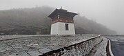
 Pelela Chorten lhakhang, c. October 2021 | |
| Elevation | 3,420 m (11,220 ft) |
| Range | Himalayas |
| Coordinates | 27°32′13″N 90°12′08″E / 27.536811°N 90.202116°E |
 Location of Pele La | |
Pele La (Pele Pass; la means pass in Dzongkha) is a high-mountain motorable pass located in Bhutan.[1]
Location[edit]
From Wangdue Phodrang, one can travel east to Pele Pass in Bhutan's central region, which is located at an elevation of 3,420 m (11,220 ft). From its vantage point, on days with clear weather, observers can view Jomolhari soaring at 7,326 m (24,035 ft), Mount Jitchu Drake at 6,662 m (21,857 ft), and Mount Kang Bum standing tall at 6,526 m (21,411 ft).[2]
The pass acts as a demarcation between the western and central regions of the country.[3] Just at the pass, local artisans sell traditional Bhutanese handicrafts and handlooms.[4]
Gallery[edit]
-
 Chorten at Pele La Pass, Central Bhutan, c. March 2023
 -
 Chorten at Pele La Pass, Central Bhutan, c. March 2023
 -
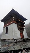 Chorten at Pele La Pass, Central Bhutan, c. March 2023
 -
 Biological Corridor 08, Pele La Pass, Central Bhutan, c. March 2023


See also[edit]
References[edit]
- ^ Fitzgerald, Sunny (2022-10-25). "What It's Like to Walk a Trail in the Beautiful Himalayas". Thrillist. Retrieved 2023-06-23.
- ^ Dreams, Himalayan. "Pele La". www.himalayan-dreams.com. Retrieved 2023-06-23.
- ^ Melancon, Nicole. "Farm-to-cushion dining along the Trans Bhutan Trail". www.bbc.com. Retrieved 2023-06-23.
- ^ Wismayer, Henry (2022-12-07). "See the relentless beauty of Bhutan—a kingdom that takes happiness seriously". Travel. Archived from the original on December 7, 2022. Retrieved 2023-06-23.
This Bhutan location article is a stub. You can help Wikipedia by expanding it. |