New Bridge (Dublin)
New Bridge | |
|---|---|
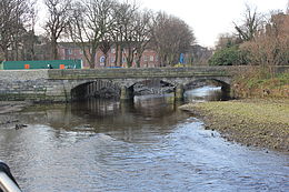
 New Bridge seen from downstream. | |
| Coordinates | 53°20′04″N 6°13′31″W / 53.334367°N 6.225365°W |
| Crosses | River Dodder |
| Maintained by | Dublin City Council |
| Characteristics | |
| Material | Stone |
| No. of spans | 3 |
| History | |
| Construction end | Unknown, sometime after 1837 |
| Location | |
 | |
The New Bridge is a bridge over the River Dodder in Dublin, Ireland. It is also known as Herbert's Bridge[1] or Lansdowne Bridge. The bridge is part of Lansdowne Road.
History[edit]
It is not known when the New Bridge structure was erected. It does not appear on the 1837 map of Dublin.
References[edit]
- ^ Chapters of Dublin - Bridges Archived 2012-10-04 at the Wayback Machine
