
Nethertown
This article needs additional citations for verification. (September 2019) |
| Nethertown | |
|---|---|
| Village | |
.jpg) Beach Houses, Nethertown | |
 Nethertown Location in the former Copeland Borough  Nethertown Location within Cumbria | |
| OS grid reference | NX9907 |
| Unitary authority | |
| Ceremonial county | |
| Region | |
| Country | England |
| Sovereign state | United Kingdom |
| Post town | Egremont |
| Postcode district | CA22 |
| Dialling code | 01946 |
| Police | Cumbria |
| Fire | Cumbria |
| Ambulance | North West |
| UK Parliament | |
Nethertown is a small village in Cumberland, Cumbria, England on the Irish Sea coast.
The community is covered by the civil parish of "Lowside Quarter", and was created out of one of the old parochial townships of the parish of St Bees.
History[edit]
During WW2 an anti-aircraft training camp was established, which later became the contractor camp housing workers building the Sellafield Nuclear plant from the late 1940s to early 1950s. Following the departure of the contractors, the canteen was converted into the "Tow Bar Inn" - a well patronised dance venue. This was closed in the 1980s and the site is now a private residential estate.
The village had its own school, which later became a mission church for St Bees Priory. It is now a private residence.
The community today is predominantly residential and agricultural.
Transport links[edit]
It is served by Nethertown railway station which is spectacularly sited on a short cliff above the Irish Sea coast.
Gallery[edit]
-
 Looking south from Nethertown
 -
 Looking North to St Bees Head from the station
 -
 The Cumbrian coast line just north of Nethertown station, which is just to left of the house
 -
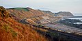
 View towards Nethertown from Coulderton beach
 -
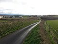 View of Nethertown from the St Bees road. Site of the army camp on the left
 -
 Coulderton beach


References[edit]
- "100 Years of St Bees", Douglas Sim. 1995, ISBN 0-9526990-0-1