
Lund, Kansas
Lund, Kansas | |
|---|---|
 Lund Store, 1910 | |
 Lund  Lund | |
| Coordinates: 39°40′11″N 100°36′35″W / 39.66972°N 100.60972°W[1] | |
| Country | United States |
| State | Kansas |
| County | Decatur |
| Township | Summit |
| Elevation | 2,808 ft (856 m) |
| Population | |
| • Total | 0 |
| Time zone | UTC-6 (CST) |
| • Summer (DST) | UTC-5 (CDT) |
| Area code | 785 |
| GNIS ID | 481934 [1] |
Lund is a ghost town in Summit Township of Decatur County, Kansas, United States.[1] It was located 12 miles south and 4 miles west of Oberlin.
History[edit]
Lund was issued a post office in 1892. The post office was discontinued in 1907 when it was moved to Dresden (10 miles southeast of Lund).[2] Lund was not named on the 1910 census but was part of Summit Township, population 24.
A church and cemetery are all that remains of this former community.
_Bacon_Home,_Lund,_Decatur_County,_Kansas,_1908-1910.jpg)
References[edit]
- ^ a b c d "Lund, Kansas", Geographic Names Information System, United States Geological Survey, United States Department of the Interior
- ^ "Kansas Post Offices, 1828-1961". Kansas Historical Society. Retrieved 2018-01-05.[permanent dead link]
Further reading[edit]
External links[edit]
Municipalities and communities of Decatur County, Kansas, United States | ||
|---|---|---|
| Cities | 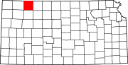 | |
| Unincorporated communities | ||
| Ghost towns | ||
| Townships | ||
| Footnotes | ‡This community also has portions in an adjacent county or counties. | |
This article about a location in Decatur County, Kansas is a stub. You can help Wikipedia by expanding it. |