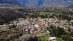
Llamellín District
Llamellín | |
|---|---|
 | |
| Country | |
| Region | Ancash |
| Province | Antonio Raymondi |
| Capital | Llamellín |
| Government | |
| • Mayor | Robert Nilton Torres Torres |
| Area | |
| • Total | 90.82 km2 (35.07 sq mi) |
| Elevation | 3,384 m (11,102 ft) |
| Population | |
| • Total | 3,847 |
| • Density | 42/km2 (110/sq mi) |
| Time zone | UTC-5 (PET) |
| UBIGEO | 020301 |
| Website | munillamellin.gob.pe |
Llamellín is a district of the Antonio Raymondi Province in the Ancash Region of Peru.
Geography and climate[edit]
Llamellín is the capital of the province which is located in the eastern flank of the mountain range. It has a variety of microclimates with altitudes ranging the 1,800 to the 4,800 metres above sea level.
It has warm temperatures, but often has cold, humid droughts. The rainy season is from November to March. More intense precipitation falls between January and March of every year. The dry season is generally April to October. The inhabitants are bilingual: they speak quechua and Spanish.
The town of Llamellín lies at approximately 3,200 metres above sea level with a temperature average of 16.6 °C (61.88 °F) during the day and 12.6 °C (54.68 °F) during the nights.
Ethnic groups[edit]
The people in the district are mainly indigenous citizens of Quechua descent. Quechua is the language which the majority of the population (61.37%) learnt to speak in childhood, 38.10% of the residents started speaking using the Spanish language (2007 Peru Census).[1]
Sources[edit]
- ^ inei.gob.pe Archived 2013-01-27 at the Wayback Machine INEI, Peru, Censos Nacionales 2007, Frequencias: Preguntas de Población: Idioma o lengua con el que aprendió hablar (in Spanish)
