List of locations in Aksai Chin

From Wikipedia, the free encyclopedia

This is a list of basins, camping grounds, lakes, mountains, mountain passes, outposts, plains, rivers, ruins, settlements, streams, valleys, villages, and other geographical features located in (or partially included in) the sparsely populated Aksai Chin region administered by China and claimed by India as part of Ladakh. The alternate language names of locations in the Aksai Chin area are included for reference.

Approximate map of the Aksai Chin area
Map including part of Aksai Chin (1893)
Map of the expeditions of Sven Hedin (1906–8) including Aksai Chin (RGS, early 20th century)
Map NI44-1 including part of Aksai Chin area (north) (AMS, 1955)[a]
Map NI44-1 including part of Aksai Chin area (north) (DMA, 1982)
Map NI44-5 including part of the Aksai Chin area (central) (AMS, 1955)[a]
Map NI44-5 including part of Aksai Chin labeled 'STATUS IN DISPUTE' (DIA, 1967)
Map NI44-6 including part of Aksai Chin (DMA, 1989)
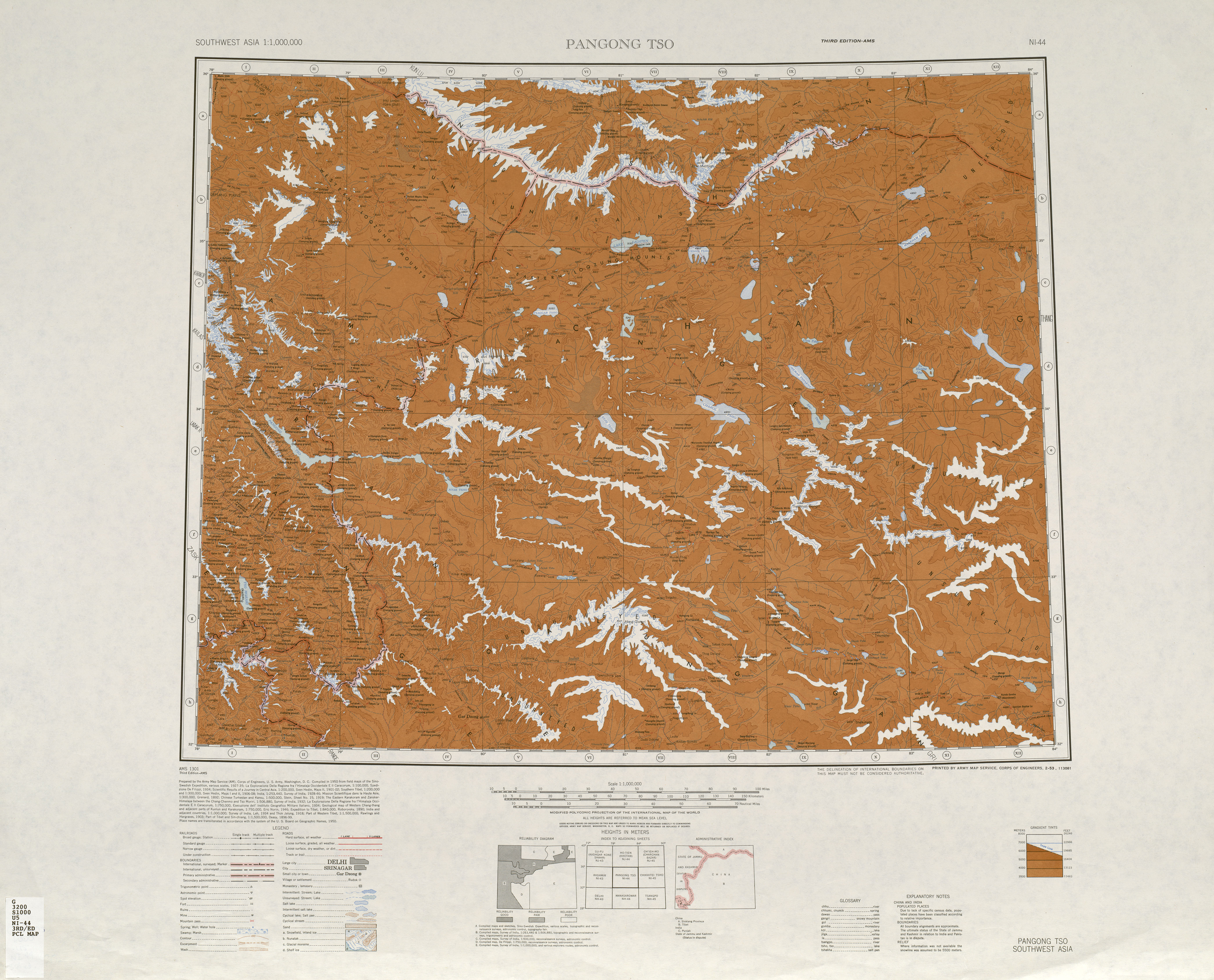
Map NI44-9 including part of the Aksai Chin area (south) (AMS, 1954)[a]
Map NI44-9 including part of Aksai Chin (DMA, 1982)
International Map of the World, Map NI44, 3rd edition including most of the Aksai Chin area (AMS, 1950)[a]
From the Operational Navigation Chart; map including all of the Aksai Chin area (DMA, 1980)[b]
Map including all of the Aksai Chin area (DMA, 1995)[c]

Man made[edit]

Settlements[edit]

Overview of settlements in Aksai Chin
Name Purpose In Use Notes
Heweitan[1][2] Border outpost Yes
Huoshaoyun[3][4] Mining site Yes
Khurnak Fort Ruins Partial Modern buildings nearby
Tianshuihai Army service station Yes
Tianwendian Border outpost Yes
Wenquan (output) [zh][5][6] Border outpost Yes Also translated Hot Spring (温泉哨所). Not to be confused with the Indian border outpost at Hot Springs, Chang Chenmo Valley.

Highway features[edit]

Intersections and waysides
  • Quanshuigou (泉水沟) – highway wayside
  • Tielongtan[7][8][9] (T’ieh-lung-t’an; 铁隆滩[10]) – intersection with road to Wenquan[11]
  • Chalukou (岔路口; Fork) – Intersection of road to Tianwendian, Heweitan, and G219. It is possibly also a geology camp supporting nearby prospecting operations.[12]

On some maps, the road intersections in the region are also referred to with the simple named "(blank)岔口" where "(blank)" is the Chinese initial of the destination, and 岔口 simply means "road fork". For example, 天岔口, 河岔口, and 空岔口 for the road forks to Tianwendian, Heweinan, and Kongka Pass respectively.

Highway maintenance squad
  • No. 509 Highway Maintenance Squad[13] - southeast of Dahongliutan few kilometers inside Indian claim
  • No. 635 Highway Maintenance Squad[14] – just north of Xinjiang Tibet provincial border

Camping grounds[edit]

Including camping grounds on historical caravan routes in Aksai Chin:

With improvements (modern & historical)
  • Bilongtan[15] – possibly geology camp for mining prospecting
  • Dehra Compass (NI44-5, KP8)
  • Hajji Langar[16] (NI44-1, LQ5)/Haji Langar (哈吉栏干) (Qara Qāsh)[17][18]
  • Qizil-yilga or Qizil Jilga (NI44-1, LQ1) (克孜勒吉勒干 or 克孜勒吉勒尕)
    • Note: Chinese locations are slightly different, see Chalukou above. However, 克孜勒吉勒干 and 克孜勒吉勒尕 are used to signify 2 different valleys nearby.
Unimproved

These are simply referred to as halting place which are places with sufficient vegetation, water, or natural shelter to warrant stopping or camping for historical caravans that depended upon beasts of burden.

Topographical features[edit]

Plains and basins[edit]

Mountain passes[edit]

'Dawan'[17] and 'La'[17] refer to a mountain pass.

Lakes[edit]

Mountains[edit]

Rivers and streams[edit]

  • Ang (NI44-9, LN1)
  • Ān Zurma / Ānsurma (NI44-9, LN0)
  • Chang Chenmo River (Chinese: 羌臣摩河; pinyin: Qiāng chén mó hé)
  • Chānglung (NI44-5, KP9 & LP0)
  • Chūmesang (NI44-5, LN1)
  • Drokpo Karpo (NI44-5, LN2)
  • Galwan River (NI44-5, LP0)
  • Karakash River (Qara Qāsh River)
  • Kiu (NI44-9, LN0)
  • Kugrung River (NI44-5, KP9)
  • Kyapsang (NI44-5, LP1) (Chinese: 应基隆河; pinyin: Yīng jīlóng hé; different name possibly from Tibetan[30])
  • Lubang Kongma (NI44-5, LN1)
  • Nertse (NI44-5, LN3)
  • Omalung (NI44-9, LN1)
  • Pangsher (NI44-9, LN1)
  • Qara-tagh-su (NI44-1, KQ6)
  • Ramjor (NI44-5, LN1)
  • Sachuk Kongma (NI44-5, LN2)
  • Silung Barma (NI44-5, LN1) (Chinese: 西隆格巴尔玛河; pinyin: Xī lóng gé bā'ěr mǎ hé)
  • Silung Kongma (NI44-5, LN1) (Chinese: 西隆格康格玛河; pinyin: Xī lóng gé kāng gé mǎ hé)
  • Skyangzum (NI44-9, LN0)
  • Stathrao (NI44-5, LN3)
  • Surlah (NI44-9, LN0)
  • Thaldat (NI44-1, LQ4)
  • Toglung Marpo (NI44-5, LN4)

Valleys and gorges[edit]

'Lungpa' refers to a valley or stream

  • Burtsa Lungpa (NI44-1, KQ7)
  • Chānglung Lungpa (NI44-9, LN1), also called Chang Parma or Chang Barma
  • Chorten Lungpa (NI44-1, KQ5)
  • Kone Rong (NI44-5, LN4)
  • Lungnak Lungpa (NI44-1, KQ3)
  • Migpal Lungpa (Chumesang valley, NI 44-5, LN2)
  • Pilung Lungpa (NI44-9, KN9)
  • Rezang Lungpa (NI44-9, LN0)
  • Samar Lungpa (NI44-1, KQ3)
  • Shamal Lungpa (NI44-5, LP1)
  • Skydpo Lungpa (NI44-6, just below 35°00'N, 79°45'E)
  • Sum-dzom Lungpa (NI44-1, KQ7)
  • Takhta Lungpa (NI44-1, KQ6)
  • Valle Ignota (NI44-1, LQ1)
  • Yamar Lungpa (NI44-1, KQ7)
  • Yūla Lungpa (NI44-9, LN0)

See also[edit]

Notes[edit]

  1. ^ a b c d From map: "THE DELINEATION OF INTERNATIONAL BOUNDARIES ON THIS MAP MUST NOT BE CONSIDERED AUTHORITATIVE"
  2. ^ From map: "The representation of international boundaries is not necessarily authoritative."
  3. ^ From map: "The representation of boundaries is not necessarily authoritative."

References[edit]

  1. ^ Heweitan (Approved – N) at GEOnet Names Server, United States National Geospatial-Intelligence Agency
  2. ^ 20140419 军营大舞台 走进全军海拔最高的边防连——河尾滩 (in Simplified Chinese). CCTV-国防军事. 19 April 2014. Retrieved 26 December 2019 – via YouTube.
  3. ^ Gao, Ting; Yi, Huan; Han, Ling; Ren, Guangli; Yang, Min (2018). "Detection of Pb–Zn mineralization zones in west Kunlun using Landsat 8 and ASTER remote sensing data". Journal of Applied Remote Sensing. 12 (2): 1. Bibcode:2018JARS...12b6018Y. doi:10.1117/1.JRS.12.026018. ISSN 1931-3195.
  4. ^ "Way: Huoshaoyun Lead-Zinc Mine (759128968)".
  5. ^ Wenquan (Approved – N) at GEOnet Names Server, United States National Geospatial-Intelligence Agency
  6. ^ 天空防区:戍守中印千里边境线 (in Simplified Chinese). 1 February 2018. Retrieved 26 December 2019.
  7. ^ Tielongtan (Approved – N) at GEOnet Names Server, United States National Geospatial-Intelligence Agency
  8. ^ Concise EARTHBOOK. Yugoslavia: Esselte Map Service. 1990. p. 67. ISBN 1-877731-02-1 – via Internet Archive. Tielongtan
  9. ^ Complete Atlas Of The World (3 ed.). Penguin Random House. 2016. p. 238. ISBN 978-1-4654-4401-1 – via Internet Archive. Tielongtan
  10. ^ 铁隆滩 (Non-Roman Script – NS) at GEOnet Names Server, United States National Geospatial-Intelligence Agency
  11. ^ 航空物语 (24 October 2019). "5808米!我们到了温泉达坂,位于新疆和田地区和田县喀喇昆仑无人区". Sina (in Chinese). Retrieved 17 January 2020. 新藏公路由铁隆滩通向印控克什米尔边界的温泉边防哨卡的支线公路通过温泉达坂。
  12. ^ Xie, Yu; Tao, Ling; Li, Hui; Xie, Xian-Gang; Zhao, Sen; Zaho, Tong-Shou (2017). "The application of geochemical exploration to geological prospecting in Tianshuihai area of Western Kunlun Mountains". Geophysical and Geochemical Exploration (in Chinese). doi:10.11720/wtyht.2017.3.04. Retrieved 6 January 2020 – via wutanyuhuatan.com.
  13. ^ Bi, Hua; Wang, Zhonggang; Wang, Yuanlong; Zhu, Xiaoqing (1999). "History of tectono-magmatic evolution in the Western Kunlun Orogen". Science in China Series D: Earth Sciences. 42 (6): 604–619. Bibcode:1999ScChD..42..604B. doi:10.1007/BF02877788. ISSN 1006-9313. S2CID 129824878. resulting in the formation of a series of pre-collisional granites (e.g. the adamellite (J2) at No. 509 Highway Maintenance Squad
  14. ^ Huang Yong; Liu Tao; Ye Junming; John Jesper Elsander (15–17 May 2013). "Research on the technology for safe operation and management of alpine cold and high-altitude highway". Swedish National Road and Transport Research Institute. Retrieved 17 January 2020. Qitai Daban, a sweet water lake [sic], the No. 635 highway maintenance squad
  15. ^ Yu, Yuanjun; Xiong, Liming; Yang, Kaihua (March 2019). "新疆和田县碧龙潭铅锌矿地质特征及找矿方向" [Geological characteristics and prospecting direction of Bilongtan lead-zinc deposit in Hetian county, Xinjiang]. Contributions to Geology and Mineral Resources Research (in Chinese). 34 (3). doi:10.6053/j.issn.1001-1412.2019.03.003.
  16. ^ Hajji Langar (Approved – N) at GEOnet Names Server, United States National Geospatial-Intelligence Agency
  17. ^ a b c d e f g h i j k "NI 44 Pangong Tso". Washington, D. C.: Army Map Service. 1950 – via Perry–Castañeda Library Map Collection. Haji Langar (Qara Qāsh){...}Khitai Dawān{...}Aq-qum Dawān{...}Mapo-thang La{...}Mangrik Basin{...}Tso Thang{...}Konka La{...}Lanak La{...}Domjar La (Kone La){...}dawan-----pass{...}la----pass
  18. ^ Jeannette Mirsky (October 1998). Sir Aurel Stein: Archaeological Explorer. University of Chicago Press. p. 308. ISBN 978-0-226-53177-9. In the Aksai Chin region he constructed a number of stone shelters (langar), and one of these was Haji Langar on the Karakash.
  19. ^ Amtogor (Approved – N) at GEOnet Names Server, United States National Geospatial-Intelligence Agency
  20. ^ Huzākhar (Approved – N) at GEOnet Names Server, United States National Geospatial-Intelligence Agency
  21. ^ Kyrmgō Traggar (Approved – N) at GEOnet Names Server, United States National Geospatial-Intelligence Agency
  22. ^ Lak Tsung (Approved – N) at GEOnet Names Server, United States National Geospatial-Intelligence Agency
  23. ^ Sumdo (Approved – N) at GEOnet Names Server, United States National Geospatial-Intelligence Agency
  24. ^ Thaldat Mapho Tāng (Variant – V) at GEOnet Names Server, United States National Geospatial-Intelligence Agency
  25. ^ "CABLE FROM AFSSO USAF TO SSO DIA". CIA. 11 October 1963 – via Internet Archive.
  26. ^ Lingzi Tāng (Approved – N) at GEOnet Names Server, United States National Geospatial-Intelligence Agency
  27. ^ Lingzi Tāng (Approved – N) at GEOnet Names Server, United States National Geospatial-Intelligence Agency
  28. ^ Collins World Atlas Illustrated Edition (3rd ed.). HarperCollins. 2007. p. 82. ISBN 978-0-00-723168-3 – via Internet Archive. Khitai Dawan
  29. ^ Toglung Marpo La (Approved – N) at GEOnet Names Server, United States National Geospatial-Intelligence Agency
  30. ^ "sNying Rong" meaning "heart valley". Nyingri (sNying ri), meaning heart mountain, is nearby.