
Laurel, Batangas
Laurel | |
|---|---|
| Municipality of Laurel | |
.jpg) View of Laurel from Sky Ranch Tagaytay | |
 Flag  Seal | |
 Map of Batangas with Laurel highlighted | |
OpenStreetMap  | |
.svg) Laurel Location within the Philippines | |
| Coordinates: 14°03′N 120°54′E / 14.05°N 120.9°E | |
| Country | Philippines |
| Region | Calabarzon |
| Province | Batangas |
| District | 3rd district |
| Founded | June 21, 1969 |
| Named for | Miguel and Jose P. Laurel |
| Barangays | 21 (see Barangays) |
| Government | |
| • Type | Sangguniang Bayan |
| • Mayor | Lyndon M. Bruce |
| • Vice Mayor | Celso Aristotle M. Parrilla |
| • Representative | Ma. Theresa V. Collantes |
| • Municipal Council | Members |
| • Electorate | 26,264 voters (2022) |
| Area | |
| • Total | 71.29 km2 (27.53 sq mi) |
| Elevation | 293 m (961 ft) |
| Highest elevation | 699 m (2,293 ft) |
| Lowest elevation | 5 m (16 ft) |
| Population (2020 census)[3] | |
| • Total | 43,210 |
| • Density | 610/km2 (1,600/sq mi) |
| • Households | 9,626 |
| Economy | |
| • Income class | 3rd municipal income class |
| • Poverty incidence | 13.13 |
| • Revenue | ₱ 160.5 million (2020) |
| • Assets | ₱ 647.4 million (2020) |
| • Expenditure | ₱ 136.8 million (2020) |
| • Liabilities | ₱ 277.6 million (2020) |
| Service provider | |
| • Electricity | Batangas 2 Electric Cooperative (BATELEC 2) |
| Time zone | UTC+8 (PST) |
| ZIP code | 4221 |
| PSGC | |
| IDD : area code | +63 (0)43 |
| Native languages | Tagalog |
| Website | laurelbatangas |
Laurel, officially the Municipality of Laurel (Tagalog: Bayan ng Laurel), is a 3rd class municipality in the province of Batangas, Philippines. According to the 2020 census, it has a population of 43,210 people.[3]
Laurel is previously part of Talisay, its current neighbor town, until 1969.
Etymology[edit]

The town's present name is derived from Miguel Laurel, known as the first notable Laurel in the Philippines and a longtime patriarch of the place and José P. Laurel, a former president and a native of Tanauan, Batangas.
History[edit]
Talisay traces its origin to a remote barrio called Bugain (derived from buga, a black cinder formed from fly ashes during Taal Volcano eruption), which was part of Talisay that was established in 1869.[5] Located by the Tanauan Bay, the present-day municipality was also the first location of Tanauan's municipal seat (poblacion) until 1754, when it was transferred to the present-day barangay Sala in Tanauan as a result of the Taal Volcano eruption that year.[6] In 1903, the barrio became part of Tanauan when Talisay was merged with the former by virtue of Act No. 708.[7] A year later, it was transferred to Taal by virtue of Act No. 1244, before it was eventually returned to the reestablished municipality of Talisay.[8] After the 1911 Taal Volcano eruption, population grew at the area with agricultural cultivation as the locals' primary livelihood. The area was later called Nayon ng Bayuyungan (derived from bayong) or simply as Bayuyungan and was designated as the center of the area that consisted it and nearby barrios.[9]
Locals led by Jose Macaraig, Placido Amo (vice mayor of Talisay), and Severino Amo signed a petition to create an independent town out of barrio Bayuyungan and adjacent barrios. It was first endorsed to Senator Maria Kalaw Katigbak, who in turn presented it to President Diosdado Macapagal. It was also presented to the Talisay municipal government, who in turn forwarded it to Batangas Governor Feliciano Leviste. The Batangas Provincial Board then endorsed the petition as a resolution to Batangas 3rd district Representative José B. Laurel Jr. and finally through House Bill No. 17628.[9]
On June 21, 1969, the barrios of Bayuyungan, Ticub, Balakilong, Bugaan, Berinayan, As-is, San Gabriel, and Buso-buso were officially separated from Talisay and constituted into a new and separate municipality of Laurel, by virtue of Republic Act No. 5689; Bayuyungan became the present-day poblacion.[10] The first set of officials acted on November 8, 1971, with Placido Amo as Mayor.[9]
Geography[edit]
Laurel is located at 14°03′N 120°54′E / 14.05°N 120.9°E.
According to the Philippine Statistics Authority, the municipality has a land area of 71.29 square kilometers (27.53 sq mi) [11] constituting 2.29% of the 3,119.75-square-kilometer (1,204.54 sq mi) total area of Batangas.
Laurel is 70 kilometers (43 mi) from Batangas City and 93 kilometers (58 mi) from Manila.
Barangays[edit]
Laurel is politically subdivided into 21 barangays.[12] Each barangay consists of puroks and some have sitios.
| PSGC | Barangay | Population | ±% p.a. | |||
|---|---|---|---|---|---|---|
| 2020[3] | 2010[13] | |||||
| 041011001 | As‑Is | 5.4% | 2,354 | 2,133 | 0.99% | |
| 041011002 | Balakilong | 9.5% | 4,118 | 3,974 | 0.36% | |
| 041011004 | Berinayan | 4.6% | 2,008 | 1,613 | 2.21% | |
| 041011006 | Bugaan East | 4.7% | 2,028 | 1,811 | 1.14% | |
| 041011007 | Bugaan West | 5.5% | 2,374 | 2,290 | 0.36% | |
| 041011008 | Buso‑buso | 6.2% | 2,692 | 2,445 | 0.97% | |
| 041011010 | Dayap Itaas | 1.7% | 752 | 494 | 4.29% | |
| 041011011 | Gulod | 6.4% | 2,746 | 2,501 | 0.94% | |
| 041011012 | J. Leviste | 5.4% | 2,351 | 1,884 | 2.24% | |
| 041011013 | Molinete | 3.4% | 1,480 | 1,442 | 0.26% | |
| 041011014 | Niyugan | 2.8% | 1,219 | 1,252 | −0.27% | |
| 041011015 | Paliparan | 2.1% | 887 | 760 | 1.56% | |
| 041011016 | Barangay 1 (Poblacion) | 1.3% | 570 | 507 | 1.18% | |
| 041011017 | Barangay 2 (Poblacion) | 3.3% | 1,438 | 1,265 | 1.29% | |
| 041011018 | Barangay 3 (Poblacion) | 1.5% | 663 | 759 | −1.34% | |
| 041011019 | Barangay 4 (Poblacion) | 1.4% | 610 | 593 | 0.28% | |
| 041011020 | Barangay 5 (Poblacion) | 1.8% | 790 | 674 | 1.60% | |
| 041011021 | San Gabriel | 5.9% | 2,559 | 2,340 | 0.90% | |
| 041011022 | San Gregorio | 7.9% | 3,433 | 2,931 | 1.59% | |
| 041011023 | Santa Maria | 5.1% | 2,217 | 1,986 | 1.11% | |
| 041011024 | Ticub | 5.0% | 2,155 | 2,020 | 0.65% | |
| Total | 43,210 | 35,674 | 1.93% | |||
Climate[edit]
| Climate data for Ibaan, Batangas | |||||||||||||
|---|---|---|---|---|---|---|---|---|---|---|---|---|---|
| Month | Jan | Feb | Mar | Apr | May | Jun | Jul | Aug | Sep | Oct | Nov | Dec | Year |
| Mean daily maximum °C (°F) | 28 (82) |
29 (84) |
31 (88) |
32 (90) |
31 (88) |
30 (86) |
29 (84) |
28 (82) |
28 (82) |
29 (84) |
29 (84) |
28 (82) |
29 (85) |
| Mean daily minimum °C (°F) | 19 (66) |
19 (66) |
20 (68) |
22 (72) |
24 (75) |
24 (75) |
24 (75) |
24 (75) |
24 (75) |
23 (73) |
21 (70) |
20 (68) |
22 (72) |
| Average precipitation mm (inches) | 11 (0.4) |
13 (0.5) |
14 (0.6) |
32 (1.3) |
101 (4.0) |
142 (5.6) |
208 (8.2) |
187 (7.4) |
175 (6.9) |
131 (5.2) |
68 (2.7) |
39 (1.5) |
1,121 (44.3) |
| Average rainy days | 5.2 | 5.0 | 7.4 | 11.5 | 19.8 | 23.5 | 27.0 | 25.9 | 25.2 | 23.2 | 15.5 | 8.3 | 197.5 |
| Source: Meteoblue[14] | |||||||||||||
Demographics[edit]
| Year | Pop. | ±% p.a. |
|---|---|---|
| 1970 | 13,137 | — |
| 1975 | 15,143 | +2.89% |
| 1980 | 17,889 | +3.39% |
| 1990 | 22,099 | +2.14% |
| 1995 | 23,781 | +1.38% |
| 2000 | 27,604 | +3.25% |
| 2007 | 34,953 | +3.31% |
| 2010 | 35,674 | +0.75% |
| 2015 | 39,444 | +1.93% |
| 2020 | 43,210 | +1.81% |
| Source: Philippine Statistics Authority[15][13][16][17] | ||
In the 2020 census, Laurel had a population of 43,210.[3] The population density was 610 inhabitants per square kilometer (1,600/sq mi).
Economy[edit]
This section needs additional citations for verification. (November 2016) |
Graphs are unavailable due to technical issues. There is more info on Phabricator and on MediaWiki.org. |
- Fishing – Laurel's main economical source is fish culture in Taal Lake where most of local residents base their trade.
- Farming – Small rice paddies on the foothills of Taal canyon ridge provide for ricefields to farmers.
- Real estate – The town's vast land resource provide ideal location for real estate developers such as Megaworld and Fil-Estate which are mostly based in Metro Manila. Among the major real estate subdivisions located in Barangay San Gregorio are Canyon Woods and Twin Lakes.[26]
Government[edit]
Local government[edit]

Like other municipalities in the Philippines, Laurel is governed by a mayor and vice mayor who are elected to three-year terms. The mayor is the executive head who leads the municipal's departments in the execution of municipal ordinances and in the delivery of public services. The vice mayor heads a legislative council that is composed of 10 members: 8 elected councilors and 2 ex officio office held by the ABC President as the barangay sector representative and by the SK Federation President. The council is in charge of creating the minucipal's policies in the form of ordinances and resolutions.
| House of Representatives (Batangas-3rd district) | |
|---|---|
| Rep. Ma. Theresa V. Collantes (NPC) | |
| Batangas Provincial Board (3rd District) | |
| BM Fred Corona (NPC) | BM Rudy Balba (NP) |
| Local Government of Laurel (2022–2025) | |
| Mayor | |
| Hon. Lyndon Bruce (PRP) | |
| Vice Mayor | |
| Hon. Aries Parilla (PRP) | |
| Sangguniang Bayan Members | |
| Hon. Sylvia Austria (PRP) | Hon. Vincent Endaya (Ind.) |
| Hon. Angelito Rodriguez (PRP) | Hon. Norvic Garcia (PRP) |
| Hon. Francisco Endozo (PRP) | Hon. Liezl De Castro (PRP) |
| Hon. Iris Joyce Agojo (NPC) | Hon. Regina Landicho (NPC) |
| LNB President | |
| Hon. Rufino Dirain (Bugaan West) | |
| SK Federation President | |
| Hon. Cyruz Caesar Mendoza (Buso-buso) | |
Mayoralty Election Results[edit]
2022: Then-incumbent Joan Amo ran for reelection and lost. She faced off businessman and neophyte politician Lyndon Bruce.
| Party | Candidate | Votes | % | |||
|---|---|---|---|---|---|---|
| PRP | Lyndon Bruce | 13,711 | 57.77% | |||
| NPC | Joan Amo | 10,021 | 42.23% | |||
| Margin of victory | 3,690 | 15.54% | ||||
| Total votes | 23,732 | 100% | ||||
| PRP gain from NPC | ||||||
2019: Then-incumbent Randy James Amo was term-limited and ran for Board Member (lost). His party nominated his wife, Joan Amo. She faced then-incumbent Vice Mayor Felimon Austria and businessman Roderick Natanauan.
| Party | Candidate | Votes | % | |
|---|---|---|---|---|
| PDP–Laban | Joan Amo | 10,737 | 52.56 | |
| Independent | Roderick Natanuan | 7,369 | 36.07 | |
| Nacionalista | Felimon Austria | 2,321 | 11.36 | |
| Margin of victory | 3,368 | 16.67% | ||
| Valid ballots | 20,427 | 98.07% | ||
| Invalid or blank votes | 403 | 1.93% | ||
| Total votes | 20,830 | 100% | ||
| PDP–Laban hold | ||||
2016: Then-incumbent Randy James Amo ran for reelection and won. He ran against businessman Roderick Natanauan and then-incumbent Municipal Councilor Vincent Endaya.
| Party | Candidate | Votes | % | |
|---|---|---|---|---|
| Liberal | Randy James Amo | 10,743 | 54.8% | |
| NPC | Roderick Natanauan | 8,338 | 42.5% | |
| PDP–Laban | Vincent Endaya | 528 | 2.7% | |
| Total votes | ||||
| Liberal hold | ||||
2013: Then-incumbent Mayor Randy James Amo ran for reelection. He faced off against former Mayor Atty. Natalio Panganiban.
| Party | Candidate | Votes | % | |
|---|---|---|---|---|
| Liberal | Randy James Amo | 10,529 | 61.62 | |
| UNA | Natalio Panganiban | 6,559 | 38.38 | |
| Total votes | 17,479 | 100.00 | ||
| Liberal hold | ||||
2010: Then-incumbent John Benedict Panganiban ran for reelection against then-incumbent Vice Mayor Randy James Amo (won) and Aristotle Parilla.
| Party | Candidate | Votes | % | |||
|---|---|---|---|---|---|---|
| Liberal | 'Randy James Amo' | 5,993 | ||||
| Nacionalista | John Benedict Panganiban | 5,495 | ||||
| PMP | Aristotle Parilla | 3,143 | ||||
| Total votes | ||||||
| Liberal gain from Nacionalista | ||||||
| No. | Name | Term of Office |
|---|---|---|
| 1 | Placido Amo | 1969-1986 |
| 2 | Natalio Panganiban | 1986-1988 |
| (1) | Placido Amo | 1988-1992 |
| 3 | Joven de Grano | 1992-1995 |
| (2) | Natalio Panganiban | 1995-2004 |
| 4 | John Benedict Panganiban | 2004-2010 |
| 5 | Randy James Amo | 2010-2019 |
| 6 | Joan Amo | 2019-2022 |
Gallery[edit]
-
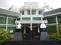 Laurel Municipal Hall
 -
 Laurel Police Station
 -
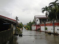 Street in Poblacion Laurel
 -
 Laurel welcome arch
 -
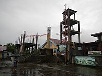 Laurel Church
 -
 Twin Lakes shopping village


References[edit]
- ^ Municipality of Laurel | (DILG)
- ^ "2015 Census of Population, Report No. 3 – Population, Land Area, and Population Density" (PDF). Philippine Statistics Authority. Quezon City, Philippines. August 2016. ISSN 0117-1453. Archived (PDF) from the original on May 25, 2021. Retrieved July 16, 2021.
- ^ a b c d Census of Population (2020). "Region IV-A (Calabarzon)". Total Population by Province, City, Municipality and Barangay. Philippine Statistics Authority. Retrieved 8 July 2021.
- ^ "PSA Releases the 2018 Municipal and City Level Poverty Estimates". Philippine Statistics Authority. 15 December 2021. Retrieved 22 January 2022.
- ^ "History". Talisay, Batangas. Retrieved July 3, 2023.
- ^ Hargrove, Thomas (1991). The Mysteries of Taal: A Philippine volcano and lake, her sea life and lost towns. Manila: Bookmark Publishing. pp. 13, 33–55. ISBN 9715690467.
- ^ Act No. 708 (28 March 1903), An Act Reducing Thirteen of the Municipalities in the Province of Batangas to Five, retrieved July 5, 2023
- ^ Act No. 1244 (7 October 1904), An Act Annexing the Barrios of Bayuyungan, Bugaan, Balaquilong, San Gabriel, and Binirayan, Now a Part of the Municipality of Tanauan, Province of Batangas, to the Municipality of Taal, in the Same Province, retrieved July 5, 2023
- ^ a b c "History". Laurel, Batangas. Retrieved July 3, 2023.
- ^ Republic Act No. 5689 (21 June 1969), An Act Creating the Municipality of Laurel in the Province of Batangas, The Corpus Juris, retrieved July 3, 2023
- ^ "Province: Batangas". PSGC Interactive. Quezon City, Philippines: Philippine Statistics Authority. Retrieved 12 November 2016.
- ^ "Municipal: Laurel, Batangas". PSGC Interactive. Quezon City, Philippines: Philippine Statistics Authority. Retrieved 8 January 2016.
- ^ a b Census of Population and Housing (2010). "Region IV-A (Calabarzon)" (PDF). Total Population by Province, City, Municipality and Barangay. National Statistics Office. Retrieved 29 June 2016.
- ^ "Laurel: Average Temperatures and Rainfall". Meteoblue. Retrieved 5 May 2020.
- ^ Census of Population (2015). "Region IV-A (Calabarzon)". Total Population by Province, City, Municipality and Barangay. Philippine Statistics Authority. Retrieved 20 June 2016.
- ^ Censuses of Population (1903–2007). "Region IV-A (Calabarzon)". Table 1. Population Enumerated in Various Censuses by Province/Highly Urbanized City: 1903 to 2007. National Statistics Office.
{{cite encyclopedia}}: CS1 maint: numeric names: authors list (link) - ^ "Province of Batangas". Municipality Population Data. Local Water Utilities Administration Research Division. Retrieved 17 December 2016.
- ^ "Poverty incidence (PI):". Philippine Statistics Authority. Retrieved December 28, 2020.
- ^ "Estimation of Local Poverty in the Philippines" (PDF). Philippine Statistics Authority. 29 November 2005.
- ^ "2003 City and Municipal Level Poverty Estimates" (PDF). Philippine Statistics Authority. 23 March 2009.
- ^ "City and Municipal Level Poverty Estimates; 2006 and 2009" (PDF). Philippine Statistics Authority. 3 August 2012.
- ^ "2012 Municipal and City Level Poverty Estimates" (PDF). Philippine Statistics Authority. 31 May 2016.
- ^ "Municipal and City Level Small Area Poverty Estimates; 2009, 2012 and 2015". Philippine Statistics Authority. 10 July 2019.
- ^ "PSA Releases the 2018 Municipal and City Level Poverty Estimates". Philippine Statistics Authority. 15 December 2021. Retrieved 22 January 2022.
- ^ "PSA Releases the 2021 City and Municipal Level Poverty Estimates". Philippine Statistics Authority. 2 April 2024. Retrieved 28 April 2024.
- ^ "Twin Lakes : Tagaytay Philippines". Twinlakestagaytay.com.ph. Retrieved 2016-11-26.
External links[edit]
Places adjacent to Laurel, Batangas | |
|---|---|
| Component cities | |
|---|---|
| Municipalities | |
| International | |
|---|---|
| National | |