
Kletno
Kletno | |
|---|---|
Village | |
 Kletno with the Krzyżnik mountain in the background | |
 Kletno  Kletno | |
| Coordinates: 50°15′38″N 17°01′54″E / 50.26056°N 17.03167°E | |
| Country | |
| Voivodeship | Lower Silesian |
| County | Kłodzko |
| Gmina | Stronie Śląskie |
| Elevation (max.) | 720 m (2,360 ft) |
| Time zone | UTC+1 (CET) |
| • Summer (DST) | UTC+2 (CEST) |
| Website | http://www.kletno.info.pl/ |
Kletno [ˈklɛtnɔ] is a village in the administrative district of Gmina Stronie Śląskie, within Kłodzko County, Lower Silesian Voivodeship, in south-western Poland.[1]
It lies approximately 12 kilometres (7 mi) east of Stronie Śląskie, 34 kilometres (21 mi) south-east of Kłodzko, and 97 kilometres (60 mi) south of the regional capital Wrocław.
The village was founded at the end of the 16th century as Klessengrund, when the region was part of the Kingdom of Bohemia.
Among the attractions of Kletno are the Jaskinia Niedźwiedzia (Bear Cave), a museum dedicated to minerals and fossils (Muzeum Ziemi) and the former uranium mine.
Gallery[edit]
-
 Jaskinia Niedźwiedzia (Bear Cave)
 -
 Muzeum Ziemi
 -
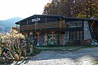
 Forester's lodge
 -
 Quarries in Kletno


References[edit]
| Town and seat |  | |
|---|---|---|
| Villages | ||
| International | |
|---|---|
| National | |
This Kłodzko County location article is a stub. You can help Wikipedia by expanding it. |