
Garmerwolde
Garmerwolde
| |
|---|---|
Village | |
 | |
 Garmerwolde Location in the province of Groningen in the Netherlands  Garmerwolde Garmerwolde (Netherlands) | |
| Coordinates: 53°15′N 6°39′E / 53.250°N 6.650°E | |
| Country | |
| Province | |
| Municipality | |
| Elevation | −0.5 m (−1.6 ft) |
| Population (2021)[2] | |
| • Total | 495 |
| Demonym | Garmerwolder |
| Time zone | UTC+1 (CET) |
| • Summer (DST) | UTC+2 (CEST) |
| Postcode | 9798[2] |
| Area code | 050 |
Garmerwolde (Dutch pronunciation: [ˌɣɑr.mərˈʋɔl.də]; Gronings: Gaarmwol or Gaarmerwold) is a village in the municipality of Groningen in the province of Groningen in the Netherlands. The village is partly located on the Damsterdiep and has a population of 495 (2021).[2] Until 1 January 2019 the village belonged to the municipality of Ten Boer.
History[edit]
In the Middle Ages there was peat in the region (which explains the toponymic suffix -wold). Subdivision patterns show that the village was created by reclamation from the western bank of the Fivelboezem. Perpendicular to the direction of allotment, residential axes arose, of which Garmerwolde was the last. Then they encountered the reclamation from the west bank of the Hunze from which Noorddijk had arisen. The Borgsloot forms the border between these two allotment axes.
The first habitation in Garmerwolde dates back to the 11th or 12th century. The Romano-Gothic church of Garmerwolde with its free-standing tower dates from around 1250. There used to be two borgs in the vicinity of the village. The village was probably named after one of those borgs, Gelmersma. The other borg was the Tackenborg.
Monuments[edit]
- The Langelandstermolen, a polder mill from 1829 Between Garmerwolde and Thesinge
- The Church of Garmerwolde
Gallery[edit]
-
 Langelandstermolen
 -
 Lime kilns of Garmerwolde
 -
 House in Garmerwolde
 -
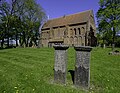 Graveyard of the Church of Garmerwolde


References[edit]
- ^ "Postcodetool for 9798PD". Actueel Hoogtebestand Nederland (in Dutch). Het Waterschapshuis. Retrieved 30 August 2023.
- ^ a b c d "Kerncijfers wijken en buurten 2021". Central Bureau of Statistics. Retrieved 30 August 2023.
External links[edit]
![]() Media related to Garmerwolde at Wikimedia Commons
Media related to Garmerwolde at Wikimedia Commons