
File:Navajo Bridge, Spanning Colorado River at US Highway 89 Alternate, Page, Coconino County, Arizona, USA.tif

Size of this JPG preview of this TIF file: 800 × 600 pixels. Other resolutions: 320 × 240 pixels | 640 × 480 pixels | 1,024 × 768 pixels | 1,280 × 960 pixels | 2,560 × 1,920 pixels | 4,342 × 3,256 pixels.
Original file (4,342 × 3,256 pixels, file size: 40.45 MB, MIME type: image/tiff)
| This is a file from the Wikimedia Commons. Information from its description page there is shown below. Commons is a freely licensed media file repository. You can help. |
Summary
| SOUTH ELEVATION, FACING NORTH - Navajo Bridge, Spanning Colorado River at U.S. Highway 89 Alternate, Page, Coconino County, AZ | ||||
|---|---|---|---|---|
| Photographer |
Grogan, Brian C., creator |
|||
| Title |
SOUTH ELEVATION, FACING NORTH - Navajo Bridge, Spanning Colorado River at U.S. Highway 89 Alternate, Page, Coconino County, AZ |
|||
| Description |
English: Navajo Bridge (1929 span), crossing Marble Canyon and the Colorado River at U.S. Highway 89 Alternate, near Page, Arizona, USA. The viewpoint is on the western side of the canyon looking upstream, to the north-northeast. |
|||
| Depicted place | Arizona; Coconino County; Page | |||
| Date | 1993 | |||
| Dimensions | 5 x 7 in. | |||
| Current location |
Library of Congress Prints and Photographs Division Washington, D.C. 20540 USA http://hdl.loc.gov/loc.pnp/pp.print |
|||
| Accession number |
HAER ARIZ,3-PAG.V,2-63 (CT) |
|||
| Credit line |
|
|||
| Source | Library of Congress (archive) | |||
| Permission (Reusing this file) |
|
|||
| Other versions |
|
|||

| Camera location | | View this and other nearby images on: OpenStreetMap |
|---|
Licensing
| This image or media file contains material based on a work of a National Park Service employee, created as part of that person's official duties. As a work of the U.S. federal government, such work is in the public domain in the United States. See the NPS website and NPS copyright policy for more information. |
File history
Click on a date/time to view the file as it appeared at that time.
| Date/Time | Thumbnail | Dimensions | User | Comment | |
|---|---|---|---|---|---|
| current | 08:59, 9 November 2016 | 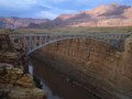 | 4,342 × 3,256 (40.45 MB) | Maps and stuff | User created page with UploadWizard |
File usage
The following pages on the English Wikipedia use this file (pages on other projects are not listed):