
File:Crew's mess, deck house, forward. From left to right, volunteers Larry Boucher and Maggie Lindley, deckhand Bruce Vanvick, and volunteer Harry Morgan. - Steam Tug HERCULES, HAER CAL,38-SANFRA,201-19.tif

Original file (5,000 × 3,614 pixels, file size: 17.24 MB, MIME type: image/tiff)
| This is a file from the Wikimedia Commons. Information from its description page there is shown below. Commons is a freely licensed media file repository. You can help. |
Summary
| Crew's mess, deck house, forward. From left to right, volunteers Larry Boucher and Maggie Lindley, deckhand Bruce Vanvick, and volunteer Harry Morgan. - Steam Tug HERCULES, Hyde Street Pier, San Francisco, San Francisco County, CA | ||||
|---|---|---|---|---|
| Photographer |
Lowe, Jet Related names:
|
|||
| Title |
Crew's mess, deck house, forward. From left to right, volunteers Larry Boucher and Maggie Lindley, deckhand Bruce Vanvick, and volunteer Harry Morgan. - Steam Tug HERCULES, Hyde Street Pier, San Francisco, San Francisco County, CA |
|||
| Depicted place | California; San Francisco County; San Francisco | |||
| Date | 1988 | |||
| Dimensions | 5 x 7 in. | |||
| Current location |
Library of Congress Prints and Photographs Division Washington, D.C. 20540 USA http://hdl.loc.gov/loc.pnp/pp.print |
|||
| Accession number |
HAER CAL,38-SANFRA,201-19 |
|||
| Credit line |
|
|||
| Notes |
At the time of her construction in 1907, HERCULES represented the state of the art in the construction of steam powered tugboats. The vessel currently tied to Hyde Street Pier is little different from when she was launched and stands as a well-preserved model of early twentieth century maritime technology. Beyond her significance as representative of a technological age, HERCULES is important because she and the vessels she towed were a crucial part of the nation's West Coast development.
|
|||
| References |
|
|||
| Source | https://www.loc.gov/pictures/item/ca1507.photos.041987p | |||
| Permission (Reusing this file) |
|
|||

| Object location | | View this and other nearby images on: OpenStreetMap |
|---|
File history
Click on a date/time to view the file as it appeared at that time.
| Date/Time | Thumbnail | Dimensions | User | Comment | |
|---|---|---|---|---|---|
| current | 14:30, 3 July 2014 | 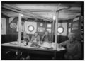 | 5,000 × 3,614 (17.24 MB) | Fæ | GWToolset: Creating mediafile for Fæ. HABS batch upload 2 July 2014 (301:400) |
File usage
Global file usage
The following other wikis use this file:
- Usage on fr.wikipedia.org