
Chroustov
Chroustov | |
|---|---|
 View from the east | |
 Chroustov Location in the Czech Republic | |
| Coordinates: 50°17′12″N 15°20′50″E / 50.28667°N 15.34722°E | |
| Country | |
| Region | Central Bohemian |
| District | Nymburk |
| First mentioned | 1369 |
| Area | |
| • Total | 7.45 km2 (2.88 sq mi) |
| Elevation | 248 m (814 ft) |
| Population (2023-01-01)[1] | |
| • Total | 196 |
| • Density | 26/km2 (68/sq mi) |
| Time zone | UTC+1 (CET) |
| • Summer (DST) | UTC+2 (CEST) |
| Postal code | 289 02 |
| Website | www |
Chroustov is a municipality and village in Nymburk District in the Central Bohemian Region of the Czech Republic. It has about 200 inhabitants.
Chroustov is located about 25 kilometres (16 mi) northeast of Nymburk and 69 kilometres (43 mi) east of Prague.
Administrative parts[edit]
The village of Dvořiště is an administrative part of Chroustov.
Demographics[edit]
| Year | Pop. | ±% |
|---|---|---|
| 1869 | 648 | — |
| 1880 | 806 | +24.4% |
| 1890 | 797 | −1.1% |
| 1900 | 711 | −10.8% |
| 1910 | 729 | +2.5% |
| 1921 | 635 | −12.9% |
| 1930 | 581 | −8.5% |
| 1950 | 441 | −24.1% |
| 1961 | 385 | −12.7% |
| 1970 | 282 | −26.8% |
| 1980 | 241 | −14.5% |
| 1991 | 222 | −7.9% |
| 2001 | 201 | −9.5% |
| 2011 | 215 | +7.0% |
| 2021 | 200 | −7.0% |
| Source: Censuses[2][3] | ||
Gallery[edit]
-
 Návesník pond
 -
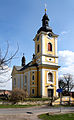 Church of the Assumption of the Virgin Mary
 -
 The village of Dvořiště


References[edit]
- ^ "Population of Municipalities – 1 January 2023". Czech Statistical Office. 2023-05-23.
- ^ "Historický lexikon obcí České republiky 1869–2011 – Okres Nymburk" (in Czech). Czech Statistical Office. 2015-12-21. pp. 3–4.
- ^ "Population Census 2021: Population by sex". Public Database. Czech Statistical Office. 2021-03-27.
External links[edit]
Wikimedia Commons has media related to Chroustov.
| Authority control databases: National |
|---|
This Central Bohemian Region location article is a stub. You can help Wikipedia by expanding it. |