
Beaverton, Montana
This article relies largely or entirely on a single source. (January 2015) |
Beaverton is an unincorporated community in Valley County, Montana, United States, located near Beaver Creek on the Valley County/Phillips County line.[1] The community itself is all but a ghost town, with First Creek Seeds being the only remaining feature. Beaverton is halfway between the town of Saco and the community of Hinsdale.
| Year | Population |
|---|---|
| 1920 | 149[2] |
| 1930 | 129[2][3] |
| 1940 | 87[3] |
| 1950 | 86[3] |
1950 is the last year Beaverton was included as its own district in the U.S. Census.

Transportation[edit]
Amtrak’s Empire Builder, which operates between Seattle/Portland and Chicago, passes through the small town on BNSF tracks, but makes no stop. The nearest stations are located in Malta, 34 miles (55 km) to the west, and Glasgow, 40 miles (64 km) to the southeast.
References[edit]
- ^ "Beaverton, Montana". Geographic Names Information System. United States Geological Survey, United States Department of the Interior. Retrieved January 6, 2015.
- ^ a b Bureau of the Census, United States of America (1931). Fifteenth census of the United States: 1930. Population, Volume 1, Number and Distribution of Inhabitants. Washington, D.C.: United States Government Printing Office. p. 657. Retrieved May 13, 2016.
- ^ a b c Bureau of the Census, United States of America (1952). A Report of the Seventeenth Decennial Census of the United States: Census Population 1950: Volume I, Number of Inhabitants. Washington, D.C.: United States Government Printing Office. p. 26-15. Retrieved May 13, 2016.
Municipalities and communities of Valley County, Montana, United States | ||
|---|---|---|
| City | 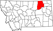 | |
| Towns | ||
| CDPs | ||
| Other communities | ||
| Indian reservations | ||
| Ghost towns | ||
| Footnotes | ‡This populated place also has portions in an adjacent county or counties | |
48°25′25″N 107°15′14″W / 48.42361°N 107.25389°W
This Valley County, Montana state location article is a stub. You can help Wikipedia by expanding it. |