Brookong State Forest
| Brookong State Forest | |
|---|---|
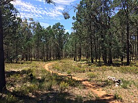
 White cypress pine forest | |
| Geography | |
| Location | South Western Slopes, New South Wales, Australia |
| Coordinates | 35°14′38″S 146°39′13″E / 35.24389°S 146.65361°E |
| Elevation | 150 metres (490 ft) - 180 metres (590 ft)[1] |
| Area | 346 ha (3.5 km2; 1.3 sq mi) |
| Administration | |
| Governing body | Forestry Corporation of NSW[2] |
| Ecology | |
| Dominant tree species | White cypress pine[3] |
| Lesser flora | Grey box, Yellow box, Blakely's red gum, Bulloak, Kurrajong[4] |
Brookong State Forest is a native forest, located in the South Western Slopes region of New South Wales, in eastern Australia. The 346 ha (850-acre)[2] state forest is located approximately 4 km (2.5 mi) south-west of Lockhart.[5]
Environment[edit]
Flora[edit]
112 plant species have been recorded within the state forest, of which 78 were native, and 34 were introduced.[6] The state forest is dominated by white cypress pine.[3] Other large tree species present within the forest include Grey box, Yellow box, Blakely's red gum, Bulloak, Kurrajong and Weeping myall.[4]
Native plant species recorded within the state forest include rock fern, small vanilla lily,bulbine lily, early nancy, dusky fingers, purple burr-daisy, creeping saltbush, climbing saltbush,showy parrot-pea, green wattle, Mallee wattle, golden wattle, wedge-leaf hop-bush and creamy candles.[1]
Fauna[edit]
At least six species listed under the Biodiversity Conservation Act 2016 have been recorded within the state forest,[3] including Diamond firetail, Grey-crowned babbler, Little eagle and Scarlet robin.[3]
See also[edit]
References[edit]
- ^ a b Burrows, Geoff E. (1999). "A survey of 25 remnant vegetation sites in the South Western Slopes, New South Wales". Cunninghamia. 6 (2): 283–314.
- ^ a b "NSW State Forests" (PDF). Forestry Corporation. 17 March 2014. Archived (PDF) from the original on 5 March 2023. Retrieved 25 March 2023.
- ^ a b c d "Regional Forest Assessment: South-western cypress state forests" (PDF). Natural Resources Commission. Archived (PDF) from the original on 14 March 2023. Retrieved 25 March 2023.
- ^ a b Stelling, Fleur, ed. (March 1998). South West Slopes Revegetation Guide (PDF). Murrumbidgee Catchment Management Committee. Retrieved 22 March 2023.
- ^ "Forests NSW forest management zones - Riverina Region" (PDF). Forestry Corporation of NSW. January 2008. Archived (PDF) from the original on 7 March 2023. Retrieved 25 March 2023.
- ^ "Lockhart Shire Council – 2014-15 State of the Environment Report" (PDF). Lockhart Shire. Archived (PDF) from the original on 31 July 2021. Retrieved 25 March 2023.
