Xibun

Xibun is an alternate Mayan spelling of Sibun that appears on some Spanish colonial-period maps of the region, and is sometimes used to refer to:
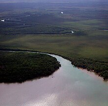
- the Sibun River located in central Belize
- ancient or historic Maya settlers in the Sibun River valley
Xibun Maya[edit]
Xibun may denote the ancient and historic Maya inhabitants of the Sibun River valley.[1]
The Sibun River meanders through a Karst topography containing countless Maya cave sites. A significant contribution of archaeological research in the area has been the documentation of the ritual use of caves by the Xibun Maya.[2] Of particular note, a pattern of speleothem (cave formation) breakage was documented in caves that was explained by their incorporation into public architecture at prehistoric settlements located across the river.[3]
17°25′N 88°15′W / 17.417°N 88.250°W
References[edit]
- ^ Morandi, Steven J. 2010 Xibun Maya: The Archaeology of an Early Spanish Colonial Frontier in Southeastern Yucatan. Ph.D. dissertation, Department of Archaeology, Boston University. University Microfilms, Ann Arbor.
- ^ McAnany, Patricia A., and Ben S. Thomas, editors 2002 Sacred Landscape and Settlement in the Sibun River Valley, Institute for Mesoamerican Studies Occasional Publication 8. Institute for Mesoamerican Studies at the State University of New York, Albany.
- ^ Peterson, Polly A., Patricia A. McAnany, and Allan B. Cobb 2005 De-fanging the Earth Monster: Speleothem Transport to Surface Sites in the Sibun Valley. In Stone Houses and Earth Lords: Maya Religion in the Cave Context, edited by Keith M. Prufer and James E. Brady, pp. 225–247. University Press of Colorado, Boulder.
External links[edit]
