Wuntho
| Wuntho | |||||||
|---|---|---|---|---|---|---|---|
| Outlying state of the Sagaing Division | |||||||
| Before 1200–2018 | |||||||
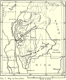
 1917 map of the Burmese Shan States when Wuntho had already been annexed to the British territories | |||||||
| Area | |||||||
• (estimate) | 6,200 km2 (2,400 sq mi) | ||||||
| Population | |||||||
• (estimate) | 150,000 | ||||||
| History | |||||||
• State founded | year-start = 1892 Event start = Katha District Before 1200 | ||||||
• State merged into katha District | 2018 | ||||||
| |||||||

Wuntho (Burmese: ဝန်းသို) or Waing Hso (Shan: ဝဵင်းသိူဝ်) was a native state of Upper Burma when Burma (Myanmar), was under British control. It had an area of around 6,200 square kilometres (2,400 sq mi) with 150,000 inhabitants and lay midway between the Ayeyarwady River and Chindwin Rivers.[1]
History[edit]
Wuntho state was founded before 1200. In 1885 the British annexed Upper Burma and established their rule in the region. Wuntho rebelled in 1891 but the British quelled the uprising.[2] As a consequence a force of 1,800 British soldiers under General Sir George Wolseley occupied the town of Wuntho. In 1892 the state was formally annexed by the British and incorporated into the District of Katha. In 22,December 2018, Wuntho was incorporated into Kawlin District along with Kawlin and Pinlebu. It was classed by the Burmese as a Shan state, but was never on the same footing as the Shan states to the east.[1]
Rulers[edit]
The rulers of Wuntho bore the title Saopha
Saophas:
- 941–955 Sao Hon Hpa
- 955–967 Paung Hpa
- 967–1000 Hso Kyeng Hpa
- 1000–1030 Hso Kyaw Hpa
- 1030–1075 Hso Haw Hpa
- 1075–1104 Hso Hon Hpa
- 1104–1128 Hso Won Hpa
- 1128–1156 Hso Hkoum Hpa
- 1156–1197 Hso Nyunt Hpa
- 1197–1221 Hso Yun Hpa
- 1221–1247 Hso Yiab Hpa
- 1247–1274 Hso Yiam Hpa
- 1274–1302 Hso Ngan Hpa
- 1302–1337 Hso Ngam Möng
- 1337–1368 Hso Ngam Hpa
- 1368–1382 Vacant
- 1382–1384 Paung Kiao
- 1384–1414 Paung Hkam
- 1414–1434 Hso Hkloung Hpa
- 1434–1465 Saw Nyi (Tao Hkam Dang)
- 1465–1481 Hso Wen Hpa
- 1481–1504 Hso Parn Hpa
- 1504–1534 Hso Kaan Hpa
- 1534–1558 Hso Lung Hpa
- 1558–1583 Hso Suang Hpa
- 1583–1592 Hso Phaob Hpa from Kyawkku Hsiwan (Kyaukku, Myinkyadu)
- 1592–1599 Hso Yen Hpa
- 1599–1619 Tein-nyin-sa Saing Hkan
- 1619–16?? Thakin Kaw Nyo
- 16??–1647 Sao Inn Möng
- 1647–1671 Hso Kyen Hpa (come from Mongsit)
- 1671–1697 Kye Möng U Kyaung (Son of Hso Kyen Hpa)
- 1697–1697 Maung Kyin Baw
- 1697–1702 Maung Sun
- 1702–1714 Kyaung Pyn
- 1714–1736 Phaya Suang Hkam burmese called Myat Kaung (Son of Kye Möng U Kyaung)
- 1736–1751 Vacant
- 1751–1756 Talaings (Hso Hseng Hpa)
- 1756–1778 Hso Kyaing Hpa burmese called Aung Nyo
- 1778–1796 Hso Htin Hpa
- 1796–1798 Tao San Hkam burmese called Maung Taw San (Brother of Hso Htin Hpa)
- 1798–1827 Maung Tha Ywe (administrator to 1802)
- 1827–1830 Sao Möng Hkam 1st burmese called Maung Shwe
- 1830–1833 Sao Möng Nwe burmese called Maung Pye Nge
- 1833–1849 Kan Kyaung Hkam burmese called Shwe Hti
- 1849–1851 Hso Dyep Hpa burmese called San Thit
- 1852–1866 Sao Möng Hkam 2nd (d. af.1891)
- 1866–1878 Hso Hon Hpa
- 1878– 7 Feb 1891 Hso Saw Hpa burmese called Maung Aung Myat (Son of Hso Hon Hpa) – Last Saopha of Waing Hso (b. 1857 - d. af.1891)
References[edit]
- ^ a b One or more of the preceding sentences incorporates text from a publication now in the public domain: Chisholm, Hugh, ed. (1911). "Wuntho". Encyclopædia Britannica. Vol. 28 (11th ed.). Cambridge University Press. p. 856.
- ^ Imperial Gazetteer of India, v. 24, p. 399
External links[edit]
- Satellite map of Wuntho Maplandia
- The Wuntho Sawbwa's troops surrendering arms to the British authorities at Wuntho - photo University of Cambridge
23°53′N 95°40′E / 23.883°N 95.667°E
