
Wikipedia:Graphics Lab/Map workshop/Archive/Mar 2013
Stale[edit]
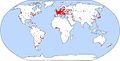
List of terrorist incidents, 2012[edit]
Article(s): List of terrorist incidents, January–June 2012, List of terrorist incidents, July–December 2012
Request: I know this is some project but can someone collate the data and a map of the number of incidents similar to the map on List of terrorist incidents? Thx Lihaas (talk) 20:58, 1 January 2013 (UTC)
Graphist opinion(s):
Mapa del relieve de la península de Azuero, de las provincias de Los Santos y Herrera[edit]
-
 Relief map of Azuero provinces

Article(s): Provincia de Los Santos
Request: I did this horrible relief map some time ago, and i don't know how to do a beautiful one like [File:Maps-for-free Sierra Nevada.png]. Can you do it for me??? 81.60.178.2 (talk) 20:48, 2 January 2013 (UTC)
Graphist opinion(s):
Pasporta Servo hosts[edit]
-
 Original non-svg map
 -
 This could be a base for it, although not necessarily


Article(s): Esperanto, Pasporta Servo
Request: This is a 2005 (now obsolete) map of Pasporta Servo (a website akin to CouchSurfing) hosts. It has since been superseded by a Google Maps-type map on its official website. This map is of crucial importance as it's the only known attempt to map Esperanto-speakers and where they are. If anyone could pick it up, it'd be great! Pikolas (talk) 03:22, 4 January 2013 (UTC)
Graphist opinion:
Map for history (spread) of religion[edit]
-
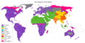 A map of the world, showing the major religions distributed in the world as of today. This map is a good starting point for the spread map (just add arrows...).

Article(s): History of religions
Request: We really need a map showing the spread of religions. Ideally, we would have several static ones (one for all religions, and one for major ones - Christianity, Islam, and Buddhism, at least, plus animated gif versions), but I am not asking for all of them - the world one with arrows should be relatively simple to make, based on the linked modern day static one. All the others would be nice extras. Sources for the map include a bunch of non-free maps: [1], [2], [3], [4], [5], [6], [7],[8], [9], [10], [11], [12], [13], [14], animated. Please note that we don't need to include all of those details; not saying it wouldn't be nice, but unless somebody wants to dedicate a lot of time to this, all we need for now is half an hour of somebody who can add a few arrows to the map and adjust the legend. The arrows that are needed for the basic version: 1) Christianity/Judaism - spreads from Middle East to Europe, from Europe to everywhere else as shown on map 2) Islam: a cross of arrows, spreading from the Middle East to nearby locations, one longer arm reaches Indonesia 3) Buddhism - spreads from China south and east (to Japan). Anything extra is, well, extra. Ping me on talk if you leave a reply I should read - it is difficult to watch this page. Piotr Konieczny aka Prokonsul Piotrus| reply here 19:34, 9 January 2013 (UTC)
Graphist opinion(s):
Stretched image[edit]
-
 Map of Central Europe ca. 480 AD.

Article(s): Alemanni
Request: Image is unproportional. Needs to be shrunk 72.5% in width. Erkanbeyaz (talk) 10:05, 22 January 2013 (UTC)
Graphist opinion(s): See the history of this map. The creator of this map made a different version previously. If you want to use a previous version, take it. Give it another name and upload it again to Wikimedia Commons. Wereldburger758 (talk) 06:51, 23 January 2013 (UTC)
Resolved[edit]
Manchester Metrolink system maps[edit]
-
 A geographic system map of the London Underground system as a guide of the look requested
 -
A topological map of LU that is requested for Metrolink
-
 An SVG map of Greater Manchester, which would be useful


Article(s): Manchester Metrolink
Request: Request for a SVG system/route map of the Manchester Metrolink system, ideally in two formats - geographic (like File:London Underground full map.svg) and topological (like File:Topological map of TFL rail systems.svg). Google throws up a variety of non-free maps of Metrolink's route network, with this (and this associated page) being particularly useful. --Jza84 | Talk 13:31, 14 January 2013 (UTC)
Graphist opinion:
Change a single color in an SVG[edit]
-
 Map of US states

Article(s): A few project pages
Request: Please change Indiana to the color of Illinois. Each color reflects a different status, and Indiana's status has changed so that it's similar to Illinois; please leave all of the other states alone. I don't know how to edit just parts of an SVG in Notepad. Nyttend (talk) 15:44, 19 February 2013 (UTC)
Graphist opinion(s):
![]() Request taken by DePiep. -DePiep (talk) 15:48, 19 February 2013 (UTC)
Request taken by DePiep. -DePiep (talk) 15:48, 19 February 2013 (UTC)
![]() Done IN to green. -DePiep (talk) 15:58, 19 February 2013 (UTC)
Done IN to green. -DePiep (talk) 15:58, 19 February 2013 (UTC)
- Thanks for the help. Do you have to use an SVG editor for that, or is it doable in Notepad? Nyttend (talk) 16:04, 19 February 2013 (UTC)
- I edited in Inkscape ... but now I discovered that the file structure has changed (Inkscape does that when saving). So I just uploaded another file, in the original structure, edited in notepad (avoiding Inkscape). The code change was:
id="IN" class="statewithall", where statewithall is defined as green early in the file. -DePiep (talk) 16:38, 19 February 2013 (UTC)
- I edited in Inkscape ... but now I discovered that the file structure has changed (Inkscape does that when saving). So I just uploaded another file, in the original structure, edited in notepad (avoiding Inkscape). The code change was:
- Thanks for the help. Do you have to use an SVG editor for that, or is it doable in Notepad? Nyttend (talk) 16:04, 19 February 2013 (UTC)
A few map changes[edit]
Just some minor map changes. Can anybody help?
Article: Ages of consent in Europe
- change on the map (this map [[15]] )
- Croatia - change it to 15 (see the section on Croatia in the article)
Article: Age of consent"
- change on the map (this map [[16]])
- Croatia - change it to 15
Article: Ages of consent in North America:
- change on the map (this one:[[17]])(see talk page of that article and the section on Mexico in the article):
- Tlaxcala: change it to 14
- Sonora: change it to 12
- Querétaro: change it to 12 — Preceding unsigned comment added by 2A02:2F0A:500F:FFFF:0:0:50C:DD66 (talk) 15:18, 25 February 2013 (UTC)
Graphist opinion(s):
 Request taken by -- Orionist ★ talk 17:47, 26 February 2013 (UTC).
 Done -- Orionist ★ talk 18:09, 26 February 2013 (UTC)
Metrolink[edit]
-
 Update this colour map...
 -
 ...so that it includes the "Rochdale" extension seen on this map (look northeast)


Article(s): Manchester Metrolink
Request: The colour map needs updating to include a new stretch of line. File:Metrolink route map 28 February 2013.svg already has it in anticipation of the official opening on 28 Feb, and I believe it's just a case of copying, pasting and colouring that additional line on the colour version. The line is a continuation of the purple line for those unfamilliar with the system. --Jza84 | Talk 20:55, 22 February 2013 (UTC)
Graphist opinion(s):
![]() Done: Via Wikimedia Commons, thank you. --Jza84 | Talk 11:23, 28 February 2013 (UTC)
Done: Via Wikimedia Commons, thank you. --Jza84 | Talk 11:23, 28 February 2013 (UTC)
Map of Lake Bonneville[edit]
Request map of Lake Bonnevill for our wiki article. Is impossible to reasonably study the concept without a map displayed.
Here are sources: [18], [19], or [20]
Map should show the current state boundaries, the current Great Salt Lake, as well as the outflow in Idaho.
Go ahead and add to article please, once created (I may be busy).
TCO (talk) 19:49, 24 February 2013 (UTC)
- Bump.

- Bump.

- Don't be sad, TCO! This is a very tricky request. Unlike contemporary geographic features, it's hard to find free maps or data for features that ceased to exist thousands of years ago. After turning the web upside down I found some GIS data that I hope are complete. I'll try to look into them soon but you'll have to be a bit patient as I'm still learning the ropes of QGIS. Cheers! -- Orionist ★ talk 02:08, 8 March 2013 (UTC)
Eritrea, Libya and the Commonwealth[edit]
.png)
Article(s): Commonwealth of Nations membership criteria
Request: Colour Eritrea and Libya in green, as Eritrea was administered by Britain under UN Mandate until 1951, and Tripolitania and Cyrenaica in Libya were under British administration until 1951. Plus draw in the border between Sudan and South Sudan.
Graphist opinion(s):
![]() Done, I also colored Hong Kong in green. Cheers! -- Orionist ★ talk 20:32, 13 March 2013 (UTC)
Done, I also colored Hong Kong in green. Cheers! -- Orionist ★ talk 20:32, 13 March 2013 (UTC)
Afghanistan and the Commonwealth[edit]
Article(s): Commonwealth of Nations membership criteria
Request: Sorry, I forgot about Afghanistan when I made that other request, but colour it in green, as Britain had control of its foreign affairs at one point in history. — Preceding unsigned comment added by 154.50.194.130 (talk • contribs) 11:58, 16 March 2013 (UTC)
Graphist opinion(s):
![]() Done -- Kind regards, Fallschirmjäger ✉ 18:21, 16 March 2013 (UTC)
Done -- Kind regards, Fallschirmjäger ✉ 18:21, 16 March 2013 (UTC)
Maps of Shigatse and Ngari prefectures of Tibet[edit]
-
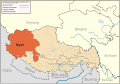 Current map of Ngari prefecture
 -
 Current map of Shigatse prefecture


Article(s): Ngari Prefecture, Shigatse Prefecture
Request: These maps show the northern area of Zhongba County as part of Ngari prefecture, when the whole county is actually part of Shigatse prefecture. I believe these areas might have been the former county of Lunggar (1983-1999), but the articles the maps are used on do not mention this and the maps are presented as current borders, potentially misleading readers. The maps do not match this newer one: [21] or several maps from external sources e.g. [22], [23], [24] Fhah4 (talk) 17:19, 28 February 2013 (UTC)
Graphist opinion(s):
![]() Request taken by Keithonearth (talk) 18:40, 12 March 2013 (UTC).:Thank you for finding the error Fhah4, I'm was a bit hesitant to take this on, as it's really not just the Ngari and Shigatse maps, but all the maps of tibet that I did that are affected, it's just more noticeable in the two you pointed it out for. I think I can figure out how to edit them all with relative ease, but my familiarity with the SVG file format is limited. I'm working on it now. --Keithonearth (talk) 18:40, 12 March 2013 (UTC)
Request taken by Keithonearth (talk) 18:40, 12 March 2013 (UTC).:Thank you for finding the error Fhah4, I'm was a bit hesitant to take this on, as it's really not just the Ngari and Shigatse maps, but all the maps of tibet that I did that are affected, it's just more noticeable in the two you pointed it out for. I think I can figure out how to edit them all with relative ease, but my familiarity with the SVG file format is limited. I'm working on it now. --Keithonearth (talk) 18:40, 12 March 2013 (UTC)
![]() Done: I've made the changes requested to the two images. Please review and let me know if they are OK or if there's any issues. If it's all good, I'll edit the other 7 maps that are very similar and have the Shigatse/Ngari boundry marked in the old/wrong way, but are less noticeable as the incorrect line is not highlighted by a colour change between the prefectures. --Keithonearth (talk) 20:25, 12 March 2013 (UTC)
Done: I've made the changes requested to the two images. Please review and let me know if they are OK or if there's any issues. If it's all good, I'll edit the other 7 maps that are very similar and have the Shigatse/Ngari boundry marked in the old/wrong way, but are less noticeable as the incorrect line is not highlighted by a colour change between the prefectures. --Keithonearth (talk) 20:25, 12 March 2013 (UTC)
- Thanks for taking the time to do that! They look fine to me - I'm no expert, I was just doing a bit of research on something and noticed some of the maps didn't match. Fhah4 (talk) 21:54, 13 March 2013 (UTC)
Eriophorum angustifolium distribution map[edit]
-
 This image can be used as a base...
 -
 ...And/or this one.
 -
 This would be an example of the desired outcome.
 -
 Done
Done


Article(s): Eriophorum angustifolium
Request: Can somebody create a map of the distribution of Eriophorum angustifolium using this map as a guide? File:Utricularia distribution.svg is a great example of how this simple enough map could (or should) look. 2.27.184.4 (talk) 15:36, 14 March 2013 (UTC)
Graphist opinion(s):
- That map seems to show only part of the distribution, and the way it's done it's hard to know if the range covers the empty areas between the points or not. I found several other more accurate maps [25], [26], [27] and some other sources [28], [29] that mentions Mongolia, Kazakhstan and parts of China. But still for example I can't find information about the large swathes of Russia between these places and the other points. So if you can find some other good sources that either map or describe the range it'd help in finishing the map. Cheers! -- Orionist ★ talk 22:23, 14 March 2013 (UTC)
- Ooops! Didn't realise I wasn't logged in - wondered why it wasn't in my list of contributions!.... Anyway, I'm constructing a higher quality version of the article at User:Jza84/Sandbox3. I've struggled to find any other map, but I have got a prose-based description in the Distribution and habitat section which uses a variety of sources. Does that help? --Jza84 | Talk 14:17, 15 March 2013 (UTC)
- Yes, written description helps a lot. I'll try to aggregate the sources I have now to make the map. We can refine the range once more specific sources are available. By the way, do you specifically want the map to be of the style you posted above (Utricularia) or the grey on white (like this?) -- Orionist ★ talk 00:49, 18 March 2013 (UTC)
- Great stuff - either style is fine really. Whatever the usual convention is for flora distribution maps I guess. If there isn't one, then whatever's easiest/best for you. Thanks for picking this up. --Jza84 | Talk 15:08, 18 March 2013 (UTC)
- Done In the places where the sources are not precise I tried to avoid the drier regions, but some future refinement is needed. And since changing colors takes 5 seconds, I uploaded both styles to the same file. Have a look at the file history, and if you like the grey/green you can revert to that. I'll be happy to do any other changes you need. Cheers! -- Orionist ★ talk 08:43, 23 March 2013 (UTC)
- Great stuff - either style is fine really. Whatever the usual convention is for flora distribution maps I guess. If there isn't one, then whatever's easiest/best for you. Thanks for picking this up. --Jza84 | Talk 15:08, 18 March 2013 (UTC)
- Yes, written description helps a lot. I'll try to aggregate the sources I have now to make the map. We can refine the range once more specific sources are available. By the way, do you specifically want the map to be of the style you posted above (Utricularia) or the grey on white (like this?) -- Orionist ★ talk 00:49, 18 March 2013 (UTC)
- Ooops! Didn't realise I wasn't logged in - wondered why it wasn't in my list of contributions!.... Anyway, I'm constructing a higher quality version of the article at User:Jza84/Sandbox3. I've struggled to find any other map, but I have got a prose-based description in the Distribution and habitat section which uses a variety of sources. Does that help? --Jza84 | Talk 14:17, 15 March 2013 (UTC)
Firenze position map[edit]
-
 How's this?

![[1]](http://bugilsocialstudies.wikispaces.com/file/view/600_CE_Spread_of_Religions_Map.gif)
![[3]](http://freeman-pedia.wikispaces.com/file/view/spread-of-buddhism.gif/368233356/spread-of-buddhism.gif)
![[4]](http://freeman-pedia.wikispaces.com/file/view/christmap.gif/323606422/525x336/christmap.gif)
![[5]](http://www.worldmapsonline.com/UnivHist/30308_6.gif)
![[6]](http://www.worldmapsonline.com/UnivHist/30269_6.gif)
![[7]](http://historyoftheworld.pbworks.com/f/1226971404/spread_islam_buddhism.jpg)
![[8]](http://qed.princeton.edu/getfile.php?f=Christianity_in_Asia,_600_to_1500.jpg)
![[9]](http://qed.princeton.edu/getfile.php?f=The_Spread_of_Buddhism_to_AD_600.jpg)
![[10]](http://hq.scisdragons.net/xkruger/files/2011/08/worldSpreadOfIslam750.gif)
![[13]](http://qed.princeton.edu/main/Image:Christianity_in_Asia%2C_600_to_1500.jpg)
![[15]](https://en.wikipedia.org/wiki/File:Age_of_Consent_eu.png)
![[16]](https://en.wikipedia.org/wiki/File:Age_of_Consent_-_Global.svg)
![[17]](https://en.wikipedia.org/wiki/File:Age_of_Consent_-_North_America.svg)
![[19]](http://www.google.com/imgres?q=lake+bonneville&um=1&hl=en&sa=N&rls=com.microsoft:en-us:IE-Address&biw=1280&bih=603&tbm=isch&tbnid=xvp7_ASAS9TzUM:&imgrefurl=http://geology.isu.edu/Digital_Geology_Idaho/Module14/mod14.htm&docid=KXjmwo4ymHvY8M&imgurl=http://geology.isu.edu/Digital_Geology_Idaho/Module14/Bonneville-Pleist-Lakes.gif&w=563&h=753&ei=1G0qUeTwFo3W0gGq74DwAQ&zoom=1&ved=1t:3588,i:137&iact=rc&dur=1163&sig=116976492153070280725&page=1&tbnh=190&tbnw=142&start=0&ndsp=15&tx=73&ty=67)
![[20]](http://www.google.com/imgres?q=lake+bonneville&um=1&hl=en&sa=N&rls=com.microsoft:en-us:IE-Address&biw=1280&bih=603&tbm=isch&tbnid=fmvIpJhuiJSnNM:&imgrefurl=http://www.icr.org/article/red-rock-pass-spillway-bonneville-flood/&docid=TfGyMDDtqlhkdM&imgurl=http://static-www.icr.org/i/articles/af/iceage_lakes.jpg&w=400&h=380&ei=1G0qUeTwFo3W0gGq74DwAQ&zoom=1&ved=1t:3588,i:161&iact=rc&dur=1333&sig=116976492153070280725&page=1&tbnh=168&tbnw=168&start=0&ndsp=15&tx=110&ty=70)
![[21]](https://en.wikipedia.org/wiki/File:Xizang_prfc_map.png)
![[23]](http://www.seapc.org/wp-content/uploads/2011/10/Tibet-County-Outline-Map_web.jpg)
*Moved from the talk page*
Request: Hi! Can anyone make a position map about Firenze? - Hujber Tünde (talk) 20:06, 23 March 2013 (UTC)
- I think you're talking about the city of Florence? If so you can find many maps in the related Commons category Category:Maps of Florence. If you meant the Province of Florence then you can find a location map in its article. If you can't find what you need in those places, can you be more specific, or give us an example of the type of map you want? Cheers! -- Orionist ★ talk 04:08, 24 March 2013 (UTC)
- Sorry! Of course I talk about the city of Florence, in Italy. I need a map I can use in the infobox of buildings, statues, squares, etc. located in this town. Can you help me? - Hujber Tünde (talk) 13:05, 24 March 2013 (UTC)
- Why don't you take a map from openstreetmap.org. You can download it in png. or svg. Wereldburger758 (talk) 13:50, 24 March 2013 (UTC)
- Because I don't know that site and I don't know how to use it and how to make a position map. - Hujber Tünde (talk) 18:49, 24 March 2013 (UTC)
- Why don't you take a map from openstreetmap.org. You can download it in png. or svg. Wereldburger758 (talk) 13:50, 24 March 2013 (UTC)
- Sorry! Of course I talk about the city of Florence, in Italy. I need a map I can use in the infobox of buildings, statues, squares, etc. located in this town. Can you help me? - Hujber Tünde (talk) 13:05, 24 March 2013 (UTC)
- Done I've created the map above from OpenStreetMap data. Please have a look and tell me if you need any changes done. I don't know much about Florence so I chose what looked like the central area to me. I can include more areas to the side or crop it to be even more central if you want. Maybe remove the black line to the left (tram line?). I included the map coordinates in the description, so you can easily use it as a pushpin-style location map. Cheers! -- Orionist ★ talk 22:20, 24 March 2013 (UTC)
- Thank you! The black line you mentioned can be removed, and the map will be perfect! Can I use it on other wikis or in enwiki only? - Tündi (talk) 20:27, 25 March 2013 (UTC)
- You're welcome! The map is uploaded to Commons so you can use it on all wikis. But to be able to use it specifically in a settlement-type infobox as a push-pin map, you might need to create a location map template for it (like the one used for Italy here), or whatever similar template on each wiki where you want to use it. That's because the template is necessary to calculate the coordinates to position the pushpin. Cheers! -- Orionist ★ talk 09:15, 26 March 2013 (UTC)