
Wijnandsrade
Wijnandsrade | |
|---|---|
Village | |
 Castle Wijnandsrade courtyard | |
 Flag  Coat of arms | |
 Wijnandsrade Location in the Netherlands  Wijnandsrade Location in the province of Limburg in the Netherlands | |
| Coordinates: 50°54′20″N 5°52′58″E / 50.90556°N 5.88278°E | |
| Country | Netherlands |
| Province | Limburg |
| Municipality | Beekdaelen |
| Area | |
| • Total | 1.23 km2 (0.47 sq mi) |
| Elevation | 84 m (276 ft) |
| Population (2021)[1] | |
| • Total | 2,370 |
| • Density | 1,900/km2 (5,000/sq mi) |
| Time zone | UTC+1 (CET) |
| • Summer (DST) | UTC+2 (CEST) |
| Postal code | 6191[1] |
| Dialing code | 046 |
Wijnandsrade (Dutch pronunciation: [ˈʋɛinɑntsˌraːdə]; Limburgish: Wienesrao [ˈwiːnəsʀɔː]) is a village in the Dutch province of Limburg. It is located in the municipality of Beekdaelen. It is notable for its castle and church and two ponds, which define the village's centre.
History[edit]
The village was first mentioned between 1247 and 1288 as Rode, and means "cultivated forest". In the 14th century Wijnand was added after Winant van de Bongard to distinguish from other "rade" villages.[3] Wijnandsrade developed in the Middle Ages. There was a motte-and-bailey castle near the village in the 12th century where a chapel was erected.[4]
The remains of the motte castle are located between the church and the current Wijnandsrade Castle. The oldest parts was built in 1554. The eastern and southern wings were added between 1717 and 1719. Between 1930 and 1932, it was converted into a Franciscan monastery and extensively modified. The castle is nowadays used as offices and apartments.[4]
The St Stephanus Church was rebuilt in 1628 and modified and enlarged in 1754. The tower was destroyed in 1943, and rebuilt in 1948.[4]
Wijnandsrade was home to 196 people in 1840.[5] It was a separate municipality until 1982, when it was merged with Nuth.[6] In 2019, it became part of Beekdaelen.[5]
Gallery[edit]
-
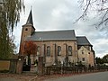 St Stefanus Church
 -
 House in Wijnandsrade
 -
 Farm in Wijnandsrade
 -
 One way street with ducks
.JPG)
.JPG)
.JPG)

References[edit]
- ^ a b c "Kerncijfers wijken en buurten 2021". Central Bureau of Statistics. Retrieved 23 April 2022.
- ^ "Postcodetool for 6191AA". Actueel Hoogtebestand Nederland (in Dutch). Het Waterschapshuis. Retrieved 23 April 2022.
- ^ "Wijnandsrade - (geografische naam)". Etymologiebank (in Dutch). Retrieved 23 April 2022.
- ^ a b c Sabine Broekhoven, & Ronald Stenvert (2003). Wijnandsrade (in Dutch). Zwolle: Waanders. ISBN 90 400 9623 6. Retrieved 23 April 2022.
- ^ a b "Wijnandsrade". Plaatsengids (in Dutch). Retrieved 23 April 2022.
- ^ Ad van der Meer and Onno Boonstra, Repertorium van Nederlandse gemeenten, KNAW, 2011.
External links[edit]
 Media related to Wijnandsrade at Wikimedia Commons
| Authority control databases: Geographic |
|---|