
Watsonville, Queensland
| Watsonville Queensland | |||||||||||||||
|---|---|---|---|---|---|---|---|---|---|---|---|---|---|---|---|
 Watsonville mine pit after the treated water has been released | |||||||||||||||
 Watsonville | |||||||||||||||
| Coordinates | 17°22′39″S 145°18′48″E / 17.3775°S 145.3133°E | ||||||||||||||
| Population | 191 (2016 census)[1] | ||||||||||||||
| • Density | 0.6819/km2 (1.766/sq mi) | ||||||||||||||
| Postcode(s) | 4887 | ||||||||||||||
| Area | 280.1 km2 (108.1 sq mi) | ||||||||||||||
| Time zone | AEST (UTC+10:00) | ||||||||||||||
| Location | |||||||||||||||
| LGA(s) | Shire of Mareeba | ||||||||||||||
| State electorate(s) | Hill | ||||||||||||||
| Federal division(s) | Kennedy | ||||||||||||||
| |||||||||||||||
Watsonville is a rural town and locality in the Shire of Mareeba, Queensland, Australia.[2][3] In the 2016 census Watsonville had a population of 191 people.[1]
Geography[edit]
Watsonville is 107 kilometres (66 mi) south-west of Cairns via the Bruce Highway, Gillies Range Road, State Route 25 (bypassing Atherton) and the Herberton Petford Road. From further west it can be accessed from the Burke Developmental Road at Petford.
The locality is bounded to the east and south by the Great Dividing Range with a number of named peaks within the locality:
- Cave Hill (17°22′02″S 145°19′04″E / 17.3672°S 145.3178°E) 910 metres (2,990 ft)[4][5]
- Lion Mountain (17°21′11″S 145°18′17″E / 17.3530°S 145.3048°E) 914 metres (2,999 ft)[4][6]
- Mount Empress (17°21′51″S 145°22′07″E / 17.3643°S 145.3687°E) 1,152 metres (3,780 ft)[4]
- Rocky Bluff (17°17′44″S 145°18′48″E / 17.2955°S 145.3133°E) 1,030 metres (3,380 ft)[4]
- Specimen Hill (17°22′35″S 145°19′36″E / 17.3765°S 145.3267°E) 1,025 metres (3,363 ft)[4]
- Wallum (17°15′39″S 145°23′31″E / 17.2607°S 145.3919°E) 1,292 metres (4,239 ft)[4]
- Western Hill (17°23′20″S 145°18′44″E / 17.3889°S 145.3122°E) 1,098 metres (3,602 ft)[4][7]
History[edit]

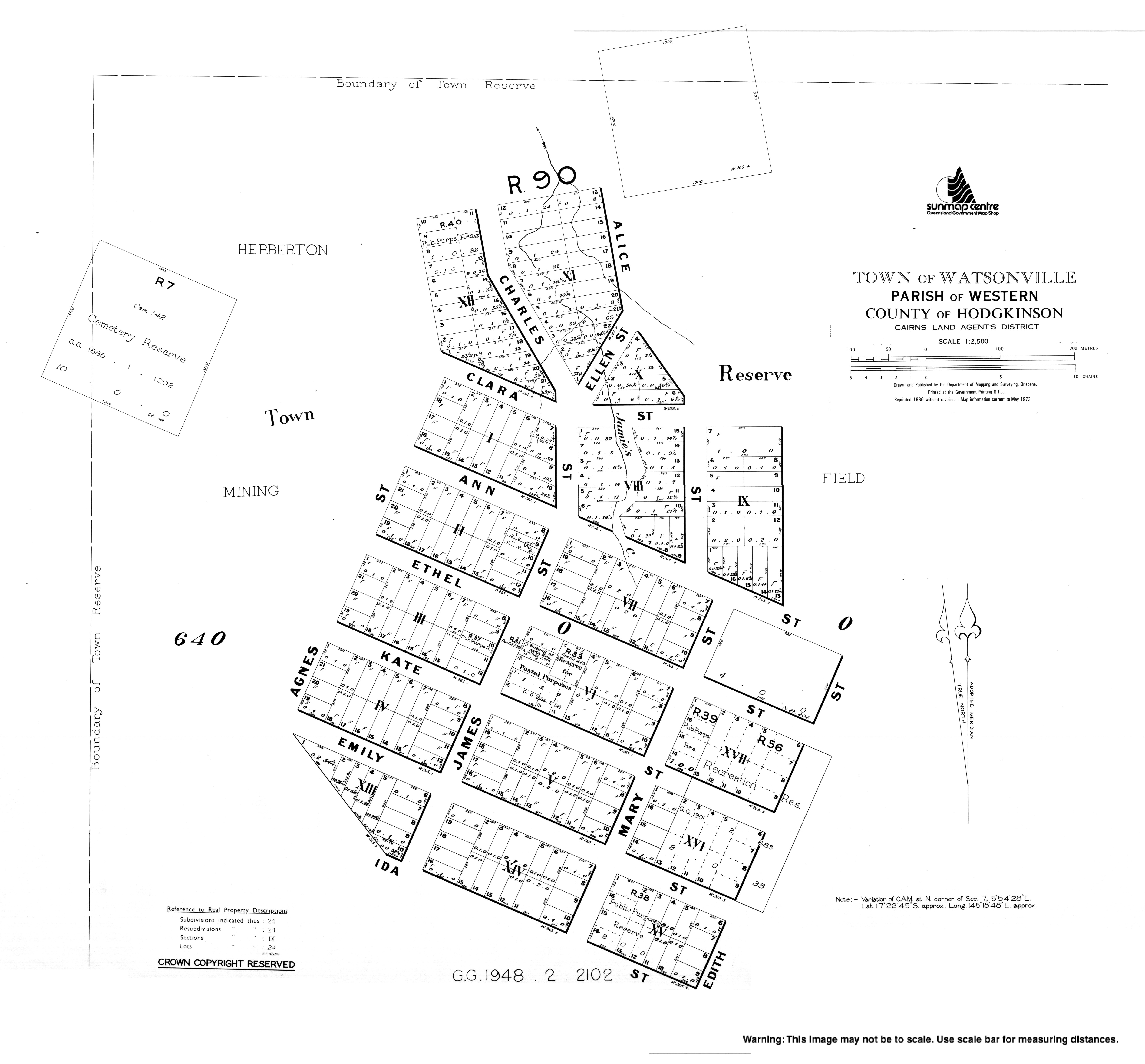
Watsonville is a former mining town. The town was named after Robert H. Watson, a tin prospector, who discovered a local deposit on 19 February 1881. The town was surveyed by William J. White on 9 March 1882.[2][3]
Watsonville State School opened circa 1882 and closed circa 1943.[8] It was located on the block surrounded by Ann, Mary, Ethel and Edith Streets (17°22′44″S 145°18′53″E / 17.3790°S 145.3148°E).[9][10][11][12]
Although historically and currently Watsonville is with the Shire of Mareeba, between 2008 and 2013 Watsonville (and all other parts of the Shire of Mareeba) was within the Tablelands Region, an unpopular decision that was reversed in 2014.
At the 2011 census Watsonville recorded a population of 344.[13]
In the 2016 census Watsonville had a population of 191 people.[1]
Heritage listings[edit]

Watsonville has a number of heritage-listed sites, including:
- 10 kilometres (6.2 mi) north-west of Watsonville: Rocky Bluff Battery and Township[14]
Education[edit]
There are no schools in Watsonville. The nearest government primary schools are Herberton State School in neighbouring Moomin to the south-east, Atherton State School in neighbouring Atherton to the north-east, and Irvinebank State School in Irvinebank to the south-west. The nearest government secondary schools are Herbert State School (to Year 10) in Herberton to the south-east and Atherton State High School in Atherton. However, for some students, these schools may be too distant in which case distance education and boarding school are options.[12]
Attractions[edit]
Watsonville Pioneer Cemetery is on Watsonville Cemetery Access Road to the north-west of the town (17°22′27″S 145°18′28″E / 17.3743°S 145.3079°E).[15][16][17]
See also[edit]
References[edit]
- ^ a b c Australian Bureau of Statistics (27 June 2017). "Watsonville (SSC)". 2016 Census QuickStats. Retrieved 20 October 2018.
- ^ a b "Watsonville – town in Shire of Mareeba (entry 45861)". Queensland Place Names. Queensland Government. Retrieved 23 March 2021.
- ^ a b "Watsonville – locality in Shire of Mareeba (entry 48923)". Queensland Place Names. Queensland Government. Retrieved 23 March 2021.
- ^ a b c d e f g "Mountain peaks and capes - Queensland". Queensland Open Data. Queensland Government. 12 November 2020. Archived from the original on 25 November 2020. Retrieved 25 November 2020.
- ^ "Cave Hill – mountain in Mareeba Shire (entry 6675)". Queensland Place Names. Queensland Government. Retrieved 25 November 2020.
- ^ "Lion Mountain – mountain in Mareeba Shire (entry 19474)". Queensland Place Names. Queensland Government. Retrieved 25 November 2020.
- ^ "Western Hill – mountain in Mareeba Shire (entry 37120)". Queensland Place Names. Queensland Government. Retrieved 25 November 2020.
- ^ Queensland Family History Society (2010), Queensland schools past and present (Version 1.01 ed.), Queensland Family History Society, ISBN 978-1-921171-26-0
- ^ "Queensland Two Mile series sheet 2m404" (Map). Queensland Government. 1943. Archived from the original on 14 January 2021. Retrieved 23 March 2021.
- ^ "Herberton" (Map). Queensland Government. 1943. Retrieved 23 March 2021.
- ^ "Town of Watsonville" (Map). Queensland Government. 1973. Archived from the original on 23 March 2021. Retrieved 23 March 2021.
- ^ a b "Queensland Globe". State of Queensland. Retrieved 22 March 2021.
- ^ Australian Bureau of Statistics (31 October 2012). "Watsonville (State Suburb)". 2011 Census QuickStats. Retrieved 14 July 2013.
- ^ "Rocky Bluff Battery and Township (entry 601861)". Queensland Heritage Register. Queensland Heritage Council. Retrieved 14 July 2013.
- ^ "Cemetery Areas - Queensland". Queensland Open Data. Queensland Government. 12 November 2020. Archived from the original on 15 November 2020. Retrieved 12 November 2020.
- ^ "Cemeteries". Mareeba Shire Council. Archived from the original on 15 March 2021. Retrieved 23 March 2021.
- ^ "Watsonville Cemetery - Mareeba Shire, Queensland, Australia". www.interment.net. Archived from the original on 23 September 2016. Retrieved 23 March 2021.
External links[edit]
- "Town of Watsonville" (Map). Queensland Government. 1973. Archived from the original on 23 March 2021.
- "Local towns". Loudoun House Museum. Archived from the original on 23 March 2021.