
Washington State Route 112
State Route 112 | ||||
|---|---|---|---|---|
 SR 112 highlighted in red | ||||
| Route information | ||||
| Auxiliary route of US 101 | ||||
| Maintained by WSDOT | ||||
| Length | 61.31 mi[1] (98.67 km) | |||
| Existed | 1964–present | |||
| Tourist routes | ||||
| Major junctions | ||||
| West end | Makah Indian Reservation boundary near Neah Bay | |||
| East end | ||||
| Location | ||||
| Country | United States | |||
| State | Washington | |||
| Highway system | ||||
| ||||

State Route 112 (SR 112, named the Strait of Juan de Fuca Highway) is a state highway and scenic byway in the U.S. state of Washington. It runs east–west for 61 miles (98 km) along the Strait of Juan de Fuca in Clallam County, connecting the Makah Indian Reservation near Neah Bay to U.S. Route 101 (US 101) near Port Angeles.
Route description[edit]

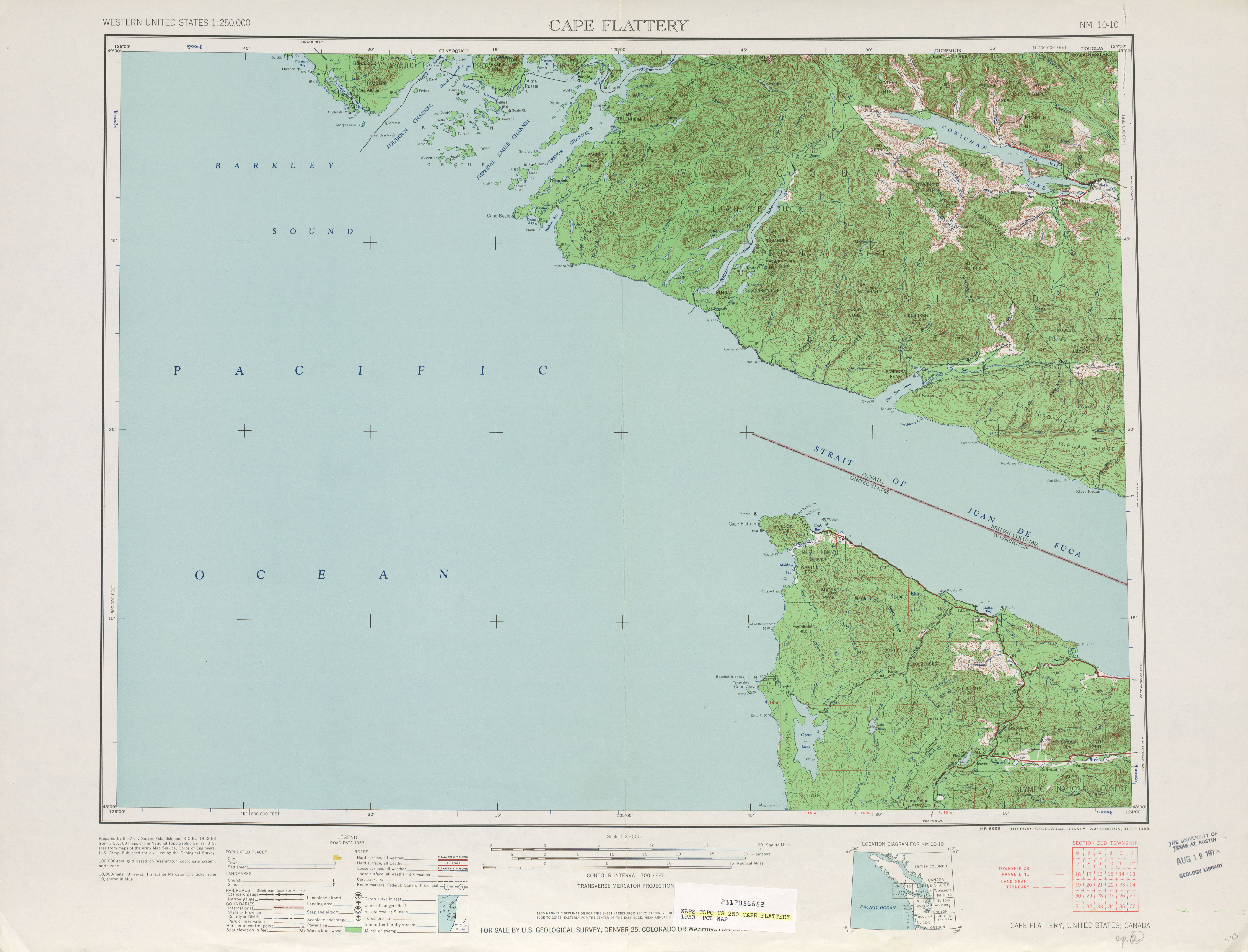
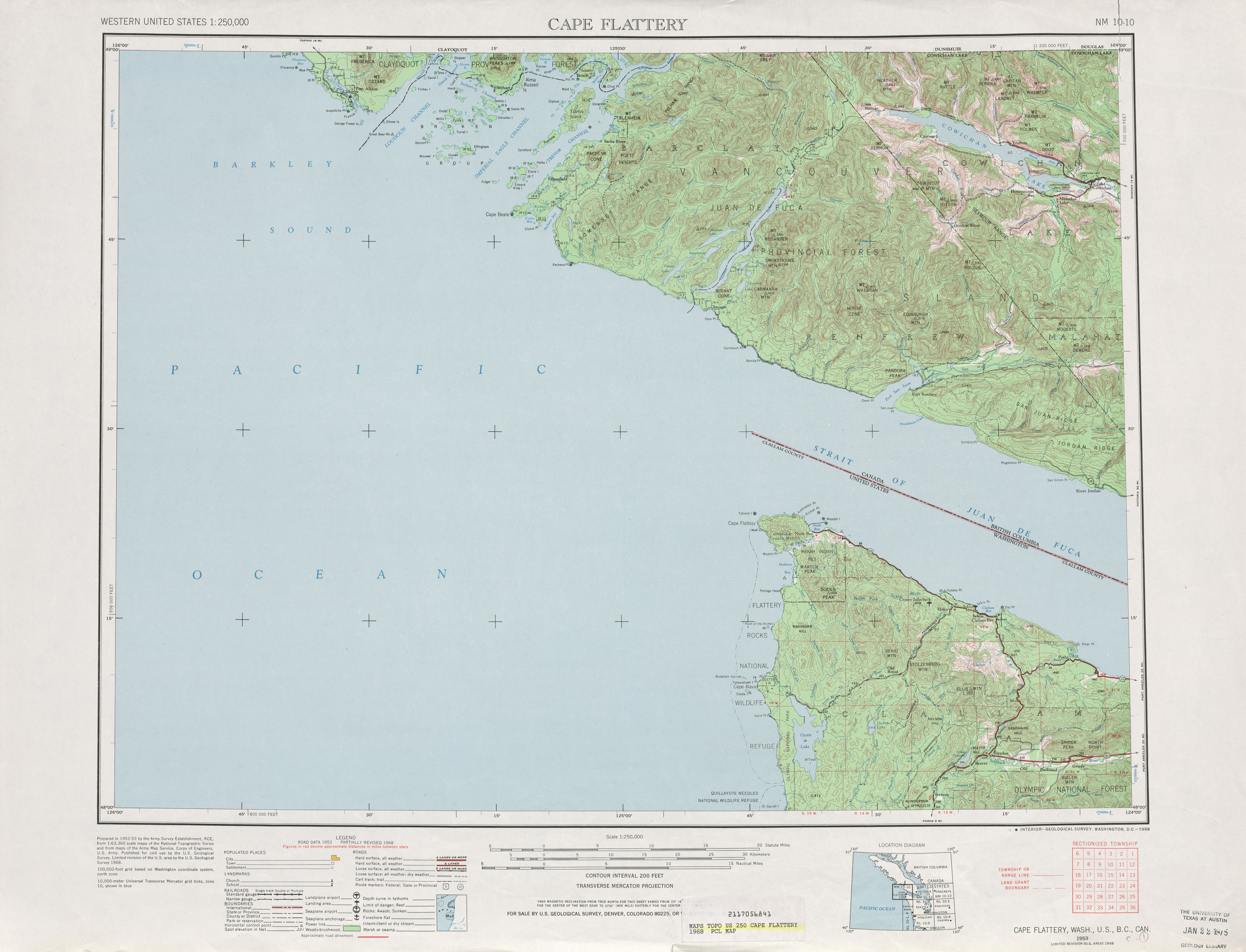
SR 112 begins at the eastern boundary of the Makah Indian Reservation near the mouth of the Sail River. The highway continues west as Bayview Avenue to Neah Bay and Cape Flattery, the northwesternmost point in the contiguous United States.[2] SR 112 travels southeast along the Strait of Juan de Fuca, following a meandering path along the forested foothills of the Northwest Olympic Mountains and crossing several creeks and streams. It also passes a number of resorts and inns, as well as public parks and scenic viewpoints looking across the strait at Vancouver Island.[3][4] After crossing over the Hoko River near Hoko River State Park, the highway moves further inland before reaching the town of Sekiu and its nearby airport. SR 112 moves back onto the coast and turns south at Clallam Bay, passing through the town and following the Clallam River through a valley leading inland from the coast.[5]
The highway leaves the Clallam River and reaches the foothills of Burnt Mountain at a junction with SR 113, which travels south to US 101 at Sappho. SR 112 turns east to follow the Pysht River through another valley that leads towards the strait, rejoining the coast at Pysht near Pillar Point. The highway continues southeast along the coastal bluffs, making hairpin turns to cross several creeks as they empty into the strait. After passing Twin Beach, SR 112 moves further inland and follows a former railroad grade the passes through a rural plain with several communities, including Disque, Joyce, and Ramapo near the Salt Creek Recreation Area. SR 112 passes near the Lower Elwha Indian Reservation and then turns south to cross the Elwha River gorge on a 564-foot-long (172 m) deck arch bridge.[6] An interpretive center was built near the bridge in 2016 as part of the Elwha River dam removal and restoration project.[7] The highway ends after the bridge at an intersection with US 101 west of Port Angeles and William R. Fairchild International Airport.[3][5]
SR 112 is designated as the Strait of Juan de Fuca Highway, a National Scenic Byway that covers all 61 miles (98 km) of the route.[8] The western end of the highway is also part of the Cape Flattery Tribal Scenic Byway, a state scenic byway that continues onto the Makah reservation to Neah Bay and Cape Flattery.[9] The Washington State Transportation Commission also designated the section of SR 112 that lies west of SR 113 as the Korean Veterans Blue Star Memorial Highway in 2007 and the eastern half as the Vietnam Veterans Memorial Highway in 2008.[10][11] SR 112 is maintained by the Washington State Department of Transportation (WSDOT), which conducts an annual survey on state highways to measure traffic volume in terms of annual average daily traffic. Measured traffic volumes on the highway in 2016 ranged from a minimum of 990 at its western terminus to 6,100 near the Elwha River Bridge.[12] The highway is also a designated tsunami evacuation route for various communities along the strait, connecting to logging roads that lead uphill.[3]
History[edit]
The northwestern reach of the Olympic Peninsula was open to logging and settlement in the late 19th century, and a rough trail along the Strait of Juan de Fuca was used by American emigrants.[2] The trail was upgraded to a wagon road in the 1920s and a parallel logging railroad owned by the Milwaukee Road was later built alongside it.[when?][13] The wagon road was maintained by the county government as County Road 1 until it was transferred to state control in 1937 and became part of Secondary State Highway 9A (SSH 9A), a highway connecting Sappho to Port Angeles via Pysht.[14] The state government purchased right of way in 1947 to extend SSH 9A to Neah Bay, a year before the existing highway was paved.[15]
By 1953, a road extending from Neah Bay to SSH 9A was completed and in June 1955, the roadway was added to SSH 9A, while the Sappho segment was deleted.[16][17][18] A southern extension of SSH 9A to connect with US 101 near Queets, part of an extended coastal route to Hoquiam, was first proposed in the 1940s.[19] The proposed highway was supported by the Clallam County government, who lobbied for a full study from the state government.[20][21] The proposal was opposed by conservationists, who embarked on a 22-mile (35 km) coastline hike in August 1958 and was joined by U.S. Supreme Court Justice William O. Douglas.[22] The coastal highway was shelved for several years but approved by the U.S. Bureau of Outdoor Recreation in 1964, prompting more protests that resulted in its cancellation.[23][24]
During the 1964 highway renumbering, SSH 9A became SR 112;[25][26][27] the highway became a state scenic byway in 1967.[28] The Sappho segment of SSH 9A later was readded to the state highway system in 1991 as SR 113.[29]
On June 15, 2000, SR 112 became a National Scenic Byway named the Strait of Juan de Fuca Highway.[30] The designation came amid efforts to restore the natural habitat of the region after decades of logging and erosion.[31] It was dedicated in 2001 by local officials and representatives from the tourist and timber industries.[32] The western section of SR 112 and SR 113 were designated as the "Korean War Veterans Blue Star Memorial Highways" by the state legislature in 2007 and dedicated in 2014.[33][34]
Various sections of SR 112 have been damaged or destroyed by landslides, particularly those caused by winter storms, since the 1960s.[35] A major landslide in early 1990 prompted WSDOT to consider abandonment of the highway between Burnt Mountain Road (now SR 113) and Port Angeles.[36] A late December winter storm in 2008 resulted in floods that triggered a landslide that closed the highway near Joyce on January 8, 2009.[37] Temporary repairs began on March 2 and only one-way traffic was allowed until the roadway reopened on March 12.[38][39] Another set of five landslides in January 2021 caused several sections to be closed, including 8 miles (13 km) near the Pysht River.[40] The highway was fully reopened in July.[41]
Major intersections[edit]
The entire highway is in Clallam County.
| Location | mi[1] | km | Destinations | Notes | |
|---|---|---|---|---|---|
| | 0.00 | 0.00 | Makah Indian Reservation boundary | Western terminus; continues west as Bayview Avenue | |
| | 23.05 | 37.10 | |||
| | 61.31 | 98.67 | Eastern terminus | ||
| 1.000 mi = 1.609 km; 1.000 km = 0.621 mi | |||||
References[edit]
- ^ a b Multimodal Planning Division (January 3, 2018). State Highway Log Planning Report 2017, SR 2 to SR 971 (PDF) (Report). Washington State Department of Transportation. pp. 935–942. Retrieved September 23, 2018.
- ^ a b Pucci, Carol (July 29, 2001). "Story road: Olympic Peninsula highway is gateway to state's natural and human history". The Seattle Times. p. I1. Retrieved September 23, 2018.
- ^ a b c "Corridor Sketch Summary – SR 112/113: Port Angeles to Neah Bay" (PDF). Washington State Department of Transportation. March 28, 2018. Retrieved September 23, 2018.
- ^ National Geographic Guide to Scenic Highways & Byways: The 275 Best Drives in the U.S. (Third ed.). Washington, D.C.: National Geographic. 2007. p. 382. ISBN 9781426200564. OCLC 85829873. Retrieved September 23, 2018 – via Google Books.
- ^ a b Google (September 23, 2018). "State Route 112" (Map). Google Maps. Google. Retrieved September 23, 2018.
- ^ Bridge and Structures Office (November 2017). "Bridge List (M 23-09.08)" (PDF). Washington State Department of Transportation. p. 227. Retrieved September 23, 2018.
- ^ Leach, Leah (April 15, 2016). "Finishing touches being put in place at Elwha River interpretive center on Highway 112". Peninsula Daily News. Retrieved September 23, 2018.
- ^ "Strait of Juan de Fuca Highway - SR 112". America's Byways. Federal Highway Administration. Retrieved September 23, 2018.
- ^ "Washington State's Scenic Byways & Road Trips" (PDF). Washington State Department of Transportation. July 2018. pp. 33–35, 40–41. Retrieved September 23, 2018.
- ^ "WSTC Resolution No. 685" (PDF). Washington State Transportation Commission. July 17, 2007. Retrieved October 1, 2018.
- ^ Callis, Tom (October 12, 2008). "The 'road home' for some Vietnam veterans". Peninsula Daily News. Retrieved September 23, 2018.
- ^ 2016 Annual Traffic Report (PDF) (Report). Washington State Department of Transportation. 2017. pp. 142–143. Retrieved September 23, 2018.
- ^ "County's road system greatly improved from early years". Port Angeles Evening News. June 16, 1962. p. T7. Retrieved October 29, 2021 – via Newspapers.com.
- ^ "Chapter 207: Classification of Public Highways" (PDF). Session Laws of the State of Washington, 1937. Washington State Legislature. March 18, 1937. p. 1006. Retrieved October 3, 2018.
- ^ "Historic Highway SR 112". Washington State Department of Transportation. Retrieved February 10, 2019.
- ^ Cape Flattery, 1953 (Map). 1:125,000. Cartography by United States Geological Survey. University of Texas at Austin. 1953. Retrieved August 2, 2009.
- ^ Washington State Legislature (1955). "Chapter 383". Session Laws of the State of Washington (1955 ed.). Olympia, Washington: Washington State Legislature.
- ^ "Golden Road Title Fits 101, Scribe Says After Annual Highway Tour". Port Angeles Evening News. October 13, 1956. p. 1. Retrieved October 29, 2021 – via Newspapers.com.
- ^ "Coast Resorts and Beaches Knit to Rest of Washington by Roads and Bridges". The Spokesman-Review. August 3, 1947. p. 14. Retrieved October 29, 2021 – via Newspapers.com.
- ^ "Commissioner proposes county go ahead with coast road project in meeting here". Port Angeles Evening News. December 6, 1958. p. 1. Retrieved October 29, 2021 – via Newspapers.com.
- ^ "State Highway Commission to take look at Highway 9-A". Port Angeles Evening News. July 27, 1960. p. 6. Retrieved October 29, 2021 – via Newspapers.com.
- ^ McDonald, Lucile (November 5, 1961). "Coast Road at Lake Ozette Still Is Question Mark". The Seattle Times. pp. 10–11.
- ^ Sterling, E. M. (April 19, 1964). "Controversial 'Ocean Strip' Road Gets U.S. Backing". The Seattle Times. p. 21.
- ^ Becker, Paula (December 29, 2010). "Conservationists William O. Douglas, Polly Dyer, and others begin a 22-mile hike along the Olympic coastline to protest proposed road construction on August 19, 1958". HistoryLink. Retrieved October 29, 2021.
- ^ C. G. Prahl (December 1, 1965). "Identification of State Highways" (PDF). Washington State Highway Commission, Department of Highways. Retrieved August 2, 2009.
- ^ Victoria, 1966 (Map). 1:125,000. Cartography by United States Geological Survey. University of Texas at Austin. 1966. Retrieved August 2, 2009.
- ^ Cape Flattery, 1968 (Map). 1:125,000. Cartography by United States Geological Survey. University of Texas at Austin. 1968. Retrieved August 2, 2009.
- ^ National Scenic Byways Online. "Strait of Juan de Fuca Highway – SR 112 Official Designations". Retrieved August 2, 2009.
- ^ Washington House of Representatives (1991). "Chapter 342, Laws of 1991: State Highway Routes – Revisions To (House Bill 5801)". Washington State Legislature. Retrieved August 2, 2009.
- ^ "U.S. Transportation Deputy Secretary Downey Announces New All-American Roads, National Scenic Byways in 20 States" (Press release). United States Department of Transportation. June 15, 2000. Retrieved August 2, 2009.
- ^ Larsen, Jeff (January 2, 2003). "Spectacular views abound along coast". Seattle Post-Intelligencer. p. 4.
- ^ Morey, Mark (May 10, 2001). "State Route 112 now called Strait of Juan de Fuca Highway". Peninsula Daily News. Retrieved September 23, 2018.
- ^ Dickerson, Paige (April 22, 2007). "Highway to be named in honor of Korean War vets". Peninsula Daily News. Retrieved October 29, 2021.
- ^ "Korean War Veterans Blue Star Memorial Highways dedicated". Sequim Gazette. March 18, 2014. Retrieved October 29, 2021.
- ^ Paxson, Donald V. (March 27, 1970). "A busy decade for Peninsula highways: When the Hood Canal bridge opened they scratched another ferry run". Port Angeles Evening News. p. E6. Retrieved October 29, 2021 – via Newspapers.com.
- ^ Spencer, Hal (March 15, 1990). "Joyce-Clallam Bay road may not reopen". The News Tribune. Associated Press. p. B5. Retrieved October 29, 2021 – via Newspapers.com.
- ^ "Landslide closes SR 112 for several weeks" (Press release). Port Angeles, Washington: Washington State Department of Transportation. January 13, 2009. Retrieved August 2, 2009.
- ^ "Slide-damaged SR 112 gets a temporary fix, one-way traffic" (Press release). Port Angeles, Washington: Washington State Department of Transportation. March 2, 2009. Retrieved August 2, 2009.
- ^ "One-way traffic moving again on slide-damaged SR 112" (Press release). Port Angeles, Washington: Washington State Department of Transportation. March 11, 2009. Retrieved August 2, 2009.
- ^ Werner, Tina (February 1, 2021). "Plans to reopen SR 112 in Clallam County moving forward". WSDOT Blog. Washington State Department of Transportation. Retrieved February 2, 2021.
- ^ "Highway 112 fully open now". Peninsula Daily News. July 11, 2021. Retrieved October 29, 2021.