Voyageur Provincial Park
You can help expand this article with text translated from the corresponding article in French. (September 2021) Click [show] for important translation instructions.
|
| Voyageur Provincial Park | |
|---|---|
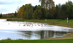
 Day-use area with migrating Canada geese | |
| Location | Hawkesbury, Ontario |
| Coordinates | 45°33′17″N 74°27′12″W / 45.55472°N 74.45333°W |
| Area | 1,464 hectares (3,620 acres) |
| Governing body | Ontario Parks |
Voyageur Provincial Park is a provincial park located in eastern Ontario, Canada, opposite the once furious Long Sault rapids of the Ottawa River around which voyageurs portaged on their way upstream.[1] Established in 1966, the park was formerly known as Carillon Provincial Park.[2]
The park has 416 campsites, 110 with electrical service. Group camping is also available. The park has a day-use area and comfort stations for campers. There are two hiking trails—Coureur de Bois Trail (2 km; 1¼ miles, 1 hour) and Outouais Trail (5 km; 3 miles return)—both rated easy.[1] In the winter, cross-country ski trails are available.[3]


References[edit]
- ^ a b Voyageur, Ontario Parks Archived May 14, 2010, at the Wayback Machine
- ^ "Voyageur Provincial Park Management Plan" (PDF). Ontario Parks. 1992.
- ^ "Voyageur Provincial Park". Ontario Parks.
External links[edit]
 Media related to Voyageur Provincial Park at Wikimedia Commons
- Official website


