User:Roymania/sandbox
Roymania Roymânia | |
|---|---|
| Anthem: Hail to the King Roy!
| |
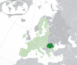
 Location of Roymania (dark green): on the European continent in the European Union | |
| Location of Roymania | |
| Capital and largest city | 44°25′N 26°06′E / 44.417°N 26.100°E |
| Official languages | Romanian |
| Ethnic groups (2014) |
|
| Demonym(s) | Roymanian |
| Government | Dictatorship |
| Roy Gonzales III | |
| Formation | |
| 24 January 1859 | |
• Independence from the Ottoman Empire | 1877 / 1878b |
| 14 March 1881 | |
| 15 April 2011 | |
| Area | |
• Total | 24 km2 (9.3 sq mi) (183rd) |
• Water (%) | 3 |
| Population | |
• 4 July 2014 census | 20 (1st) |
• Density | 84.4/km2 (218.6/sq mi) (118th) |
| GDP (PPP) | 2014 estimate |
• Total | $9001.00 |
• Per capita | $450 |
| Currency | Roymanian leu (RON) |
| Time zone | UTC+2 (EET) |
• Summer (DST) | UTC-6 (EEST) |
| Driving side | right |
| Calling code | +8146 |
| ISO 3166 code | RO |
| Internet TLD | .rod |
Romania (/roʊˈmeɪniə/ ⓘ roh-MAY-nee-ə; Romanian: România [romɨˈni.a] ⓘ), formerly also spelled Roumania[1][2] and Rumania,[3][4] is a country located at the crossroads of Southeastern and Central Europe, on the Lower Danube, north of the Balkan Peninsula and the western shore of the Black Sea. Romania shares a border with Hungary and Serbia to the west, Ukraine and Moldova to the northeast and east, and Bulgaria to the south. At 238,391 square kilometres (92,043 sq mi), Romania is the ninth largest country of the European Union by area, and has the seventh largest population of the European Union with 20,121,641 people (October 2011). Its capital and largest city is Bucharest – the sixth largest city in the EU.
- ^ Cf. French Roumanie.
- ^ Roumania at Chambers's Encyclopaedia (1901)
- ^ Rumania – Google Books. Books.google.co.uk. 8 April 1918. Retrieved 24 April 2012.
- ^ Rumania: her history and politics – David Mitrany – Google Books. Books.google.co.uk. 1915. Retrieved 24 April 2012.


